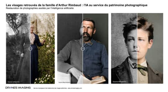
Rediscovering the Faces of Arthur Rimbaud’s Family: AI... Achievement July 22, 2026 An exploration of how AI can help restore and pass on the photographic heritage of the 19th century. At Continuer la lecture
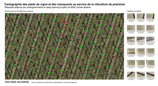
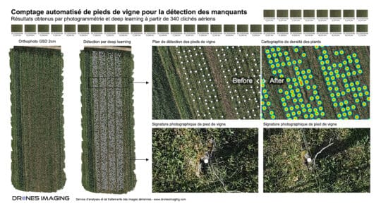
High-resolution mapping of vineyard plots and identification of... geomatics March 3, 2026 Automated Detection of Vine Plants and Missing Vines in the Saint-Émilion Vineyard Automated Detection and Geolocation of Vine Stocks Continuer la lecture
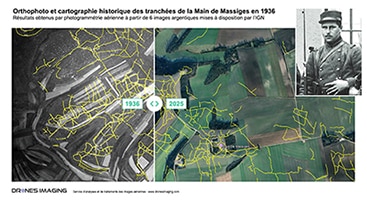
The trenches of the Battle of the Marne... geomatics January 22, 2025 Mapping of the trench network at the Main de Massiges created from 1936 aerial film images A detailed map Continuer la lecture
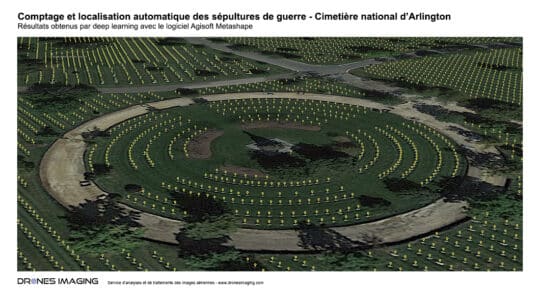
Automated Mapping of War Graves – Arlington National... Non classé January 17, 2024 Automatic Detection and Localization of Graves in a Military Cemetery using Agisoft Metashape Software Automatic tomb counting at Arlington Continuer la lecture
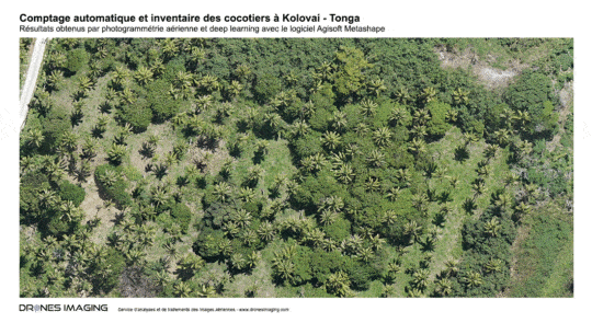
Automated coconut tree counting in Kolovai – Tonga... geomatics November 20, 2023 Automatic Detection and Localization of Coconut Trees Using Agisoft Metashape Software Automated coconut tree counting on a 300ha area: Continuer la lecture
Automatic Detection of Grapevines using Deep Learning geomatics October 30, 2023 Automatic Detection of Grapevines on a plot in Australia Automatic Detection of Grapevines and Missing Ones on a vineyard Continuer la lecture
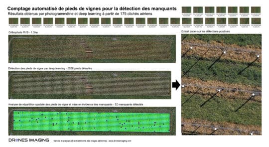
Automated counting of grapevine plants for the detection... geomatics April 15, 2023 Automated counting of grapevine plants in Yonne Grapevine plant counting and missing plants: results achieved through photogrammetry and deep Continuer la lecture
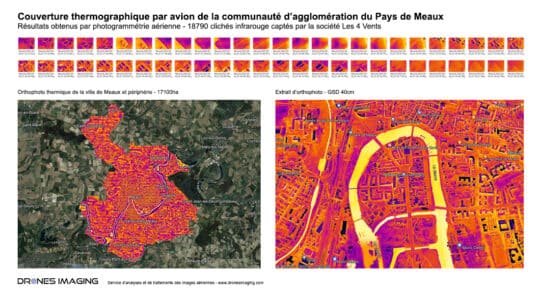
Energy diagnosis of the urban community of Meaux geomatics March 22, 2023 Aerial thermography by plane for the energy diagnosis of the urban community of Meaux Aerial thermography by plane: results Continuer la lecture
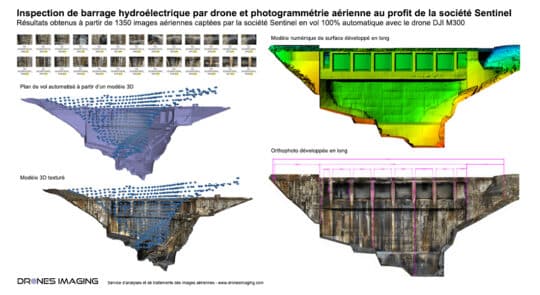
Visual inspection and safety study of a dam... geomatics March 14, 2023 Dam auscultation by drone, crack detection, and monitoring of the structure over time Dam inspection by drone: results obtained Continuer la lecture
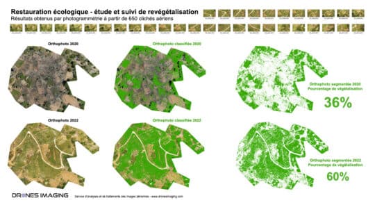
Revegetation percentage calculation for an ecological restoration project geomatics October 5, 2022 Ecological restoration and calculation of revegetation percentage made by drone Ecological restoration: results obtained from 1187 aerial images taken Continuer la lecture
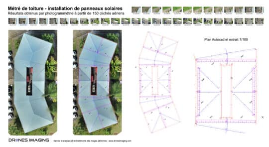
Complex roof survey carried out by drone geomatics September 29, 2022 Roof measurements: Autocad plan built by drone and aerial photogrammetry. Roof measurements: results obtained from 400 aerial shots on Continuer la lecture
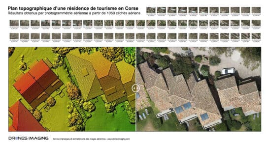
Topographic map of a tourist complex in Corsica geomatics July 25, 2022 Autocad plan built by photogrammetry from aerial images. Results obtained from 1050 aerial images over a 5ha total area Continuer la lecture
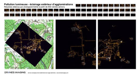
Study of light pollution for energy waste and... geomatics May 4, 2022 Light pollution – nocturnal orthophoto made by aerial photogrammetry Results obtained from 650 aerial images over a 22km² area Continuer la lecture
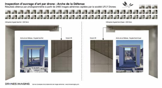
Inspection of engineering works carried out by drone... geomatics March 11, 2022 Sub-millimeter orthofacades of the Arche de la Défense vertical walls Results obtained from 2640 aerial images taken by the Continuer la lecture
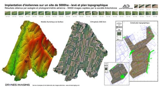
Topographic survey carried out by gyrocopter geomatics July 16, 2021 Topographic survey of 5000ha carried out by gyrocopter and aerial photogrammetry. Autocad topographic plans made from MNS and orthophoto Continuer la lecture
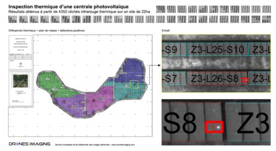
Inspection of a photovoltaic power plant carried out... geomatics July 13, 2021 Thermographic inspection of a photovoltaic power plant Results obtained from 4352 aerial images taken by Tech Drone Service company. Continuer la lecture
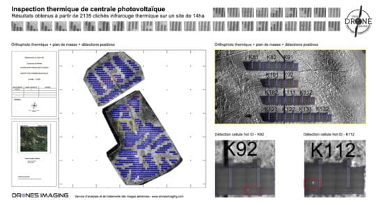
Thermal inspection of a photovoltaic power plant carried... geomatics July 12, 2021 Thermal inspection of a photovoltaic power plant carried out by drone and aerial photogrammetry Résults obtained from 23135 aerial Continuer la lecture
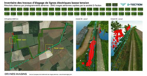
High voltage lines inspection: cable extraction and 3D... geomatics July 6, 2021 3D modeling of electrical cables in the form of 3D polylines for vegetation management under power lines Results obtained Continuer la lecture
Lettuces automatic counting by drone and machine learning geomatics June 24, 2021 Automatic counting plants by drone from multispectral orthophoto Automatic counting carried out by machine learning and subsequently, NDVI classification Continuer la lecture
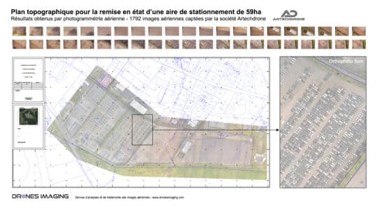
Survey map of a parking area built by... geomatics June 10, 2021 Autocad road plan of a parking area produced by drone and aerial photogrammetry. Standardizes autocad road plan of a Continuer la lecture