Skip to content
Services et traitements des images aériennes
Twitter Facebook Linkedin
  • Français
  • English
DRONES IMAGING
  • Drones imaging
    • Who are we
  • images processing service
    • topographic service
    • thermographic service
    • agricultural service
    • automatic counting service
    • Use case
    • Product sheets
    • useful documentation
    • download guide
  • Trainings
    • training in photogrammetry metashape option
    • training in photogrammetry Pix4D option
    • Multispectral training
    • online photogrammetry training
  • Softwares
    • Agisoft Metashape photogrammetry software
    • RealityCapture photogrammetry software
    • Undet software
  • RTK Receivers
    • EMLID GNSS RTK Reach RS2+
    • Emlid GNSS RTK Reach RX
    • EMLID GNSS RTK Reach RS+
  • Sensors
    • Agrowing Multispectral cameras
  • News
  • Contact us
Menu Close
  • Drones imaging
    • Who are we
  • images processing service
    • topographic service
    • thermographic service
    • agricultural service
    • automatic counting service
    • Use case
    • Product sheets
    • useful documentation
    • download guide
  • Trainings
    • training in photogrammetry metashape option
    • training in photogrammetry Pix4D option
    • Multispectral training
    • online photogrammetry training
  • Softwares
    • Agisoft Metashape photogrammetry software
    • RealityCapture photogrammetry software
    • Undet software
  • RTK Receivers
    • EMLID GNSS RTK Reach RS2+
    • Emlid GNSS RTK Reach RX
    • EMLID GNSS RTK Reach RS+
  • Sensors
    • Agrowing Multispectral cameras
  • News
  • Contact us

Blog

    News   Topographic survey carried out by gyrocopter

Topographic survey carried out by gyrocopter

  • July 16, 2021
  • 2:03 pm

Topographic survey of 5000ha carried out by gyrocopter and aerial photogrammetry.

Autocad topographic plans made from MNS and orthophoto on a 5000ha area.

Results obtained from 30,000 aerial images taken by the company Artech’Drone.

Digital surface model, orthophoto and topographic maps

DSM orthophoto et plan topographique

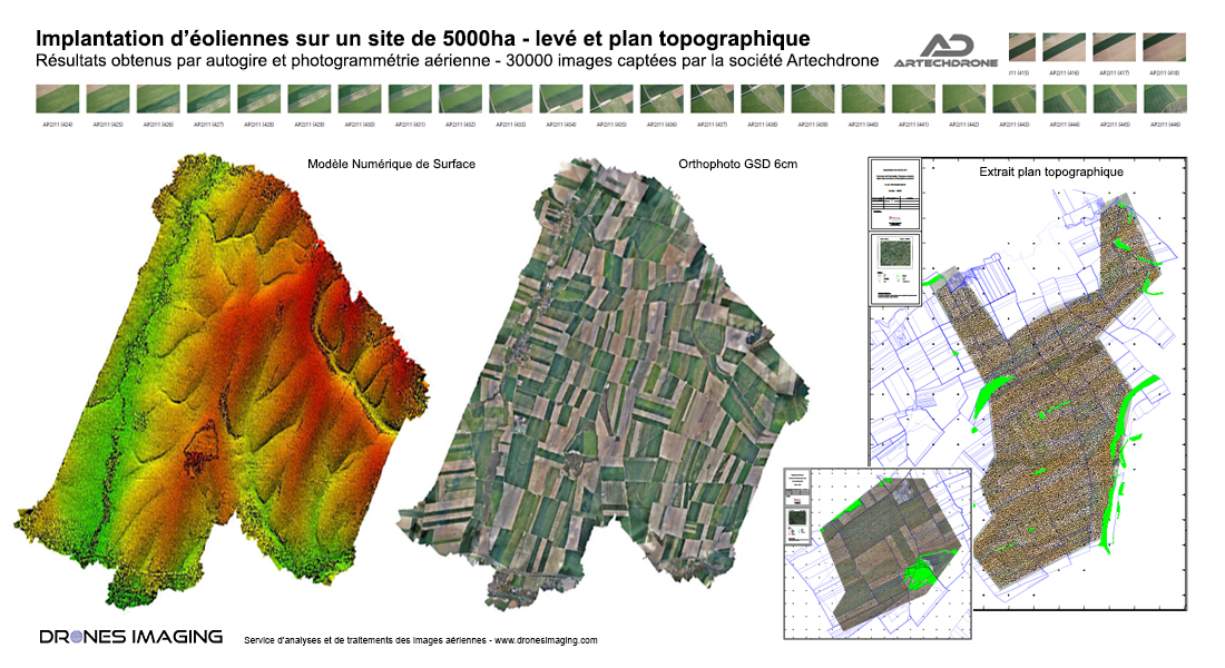
Above are two example topographic maps on which appear: terrain topography, elevations cotations, slopes, ditches, vegetation, tracks, cadastre and all the useful informations for sizing and setting up a future wind farm.

Turnkey maps directly delivered to the design office in charge of the wind turbine installation project and the consolidation of agricultural plots up to date +7 upon receipt of the images.

TECHNICAL INFORMATIONS

  • Data processing & geomatics sservice : Drones Imaging
  • Aerial images source : Artech’Drone
  • Spatial accuracy : centimeter with EMLID Reach RS2 receiver.
  • Orthophoto RVB : 6cm GSD
  • Covered area : 5000ha
  • Airborn platform : Gyrocopter
  • Camera : Sony A6000
  • Photogrammetry software : Metashape
PrevPrécédentInspection of a photovoltaic power plant carried out by drone and aerial thermography
SuivantInspection of engineering works carried out by drone and aerial photogrammetryNext
  • Mentions légales
  • FrançaisFrançais
  • EnglishEnglish