Skip to content
Services et traitements des images aériennes
Twitter Facebook Linkedin
  • Français
  • English
DRONES IMAGING
  • Drones imaging
    • Who are we
  • images processing service
    • topographic service
    • thermographic service
    • agricultural service
    • automatic counting service
    • Use case
    • Product sheets
    • useful documentation
    • download guide
  • Trainings
    • training in photogrammetry metashape option
    • training in photogrammetry Pix4D option
    • Multispectral training
    • online photogrammetry training
  • Softwares
    • Agisoft Metashape photogrammetry software
    • RealityCapture photogrammetry software
    • Undet software
  • RTK Receivers
    • EMLID GNSS RTK Reach RS2+
    • Emlid GNSS RTK Reach RX
    • EMLID GNSS RTK Reach RS+
  • Sensors
    • Agrowing Multispectral cameras
  • News
  • Contact us
Menu Close
  • Drones imaging
    • Who are we
  • images processing service
    • topographic service
    • thermographic service
    • agricultural service
    • automatic counting service
    • Use case
    • Product sheets
    • useful documentation
    • download guide
  • Trainings
    • training in photogrammetry metashape option
    • training in photogrammetry Pix4D option
    • Multispectral training
    • online photogrammetry training
  • Softwares
    • Agisoft Metashape photogrammetry software
    • RealityCapture photogrammetry software
    • Undet software
  • RTK Receivers
    • EMLID GNSS RTK Reach RS2+
    • Emlid GNSS RTK Reach RX
    • EMLID GNSS RTK Reach RS+
  • Sensors
    • Agrowing Multispectral cameras
  • News
  • Contact us

Blog

    News   Thermal inspection of a photovoltaic power plant carried out by drone and aerial photogrammetry

Thermal inspection of a photovoltaic power plant carried out by drone and aerial photogrammetry

  • July 12, 2021
  • 1:22 pm

Thermal inspection of a photovoltaic power plant carried out by drone and aerial photogrammetry

Résults obtained from 23135 aerial images taken by Tech Drone Service company.

Autocad map built from thermal orthophoto on a 14ha area.

Defects map with thermal orthophoto background

Thermal inspection by UAV

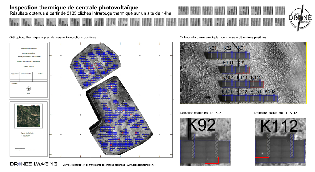
Above the map and its 720 inspected panels, including 4 “bypass diode” malfunctions and 33 overheated cells (hot spots) detected thanks to their high temperature.

Turnkey map delivered to the design and construction manager before commissioning the site.

TECHNICAL INFORMATIONS

  • Data processing service : Drones Imaging company.
  • Aerial images captation : Tech Drone Service company.
  • Spatial accuracy : centimeter.
  • Thermal orthophoto : 3cm GSD.
  • Covered area : 14ha.
  • Drone : DJI P4P.
  • Sensor : FLIR XT2.
  • Photogrammétry software : Agisoft Metashape.
PrevPrécédentHigh voltage lines inspection: cable extraction and 3D modeling from aerial images
SuivantInspection of a photovoltaic power plant carried out by drone and aerial thermographyNext
  • Mentions légales
  • FrançaisFrançais
  • EnglishEnglish