Skip to content
Services et traitements des images aériennes
Twitter Facebook Linkedin
  • Français
  • English
DRONES IMAGING
  • Drones imaging
    • Who are we
  • images processing service
    • topographic service
    • thermographic service
    • agricultural service
    • automatic counting service
    • Use case
    • Product sheets
    • useful documentation
    • download guide
  • Trainings
    • training in photogrammetry metashape option
    • training in photogrammetry Pix4D option
    • Multispectral training
    • online photogrammetry training
  • Softwares
    • Agisoft Metashape photogrammetry software
    • RealityCapture photogrammetry software
    • Undet software
  • RTK Receivers
    • EMLID GNSS RTK Reach RS2+
    • Emlid GNSS RTK Reach RX
    • EMLID GNSS RTK Reach RS+
  • Sensors
    • Agrowing Multispectral cameras
  • News
  • Contact us
Menu Close
  • Drones imaging
    • Who are we
  • images processing service
    • topographic service
    • thermographic service
    • agricultural service
    • automatic counting service
    • Use case
    • Product sheets
    • useful documentation
    • download guide
  • Trainings
    • training in photogrammetry metashape option
    • training in photogrammetry Pix4D option
    • Multispectral training
    • online photogrammetry training
  • Softwares
    • Agisoft Metashape photogrammetry software
    • RealityCapture photogrammetry software
    • Undet software
  • RTK Receivers
    • EMLID GNSS RTK Reach RS2+
    • Emlid GNSS RTK Reach RX
    • EMLID GNSS RTK Reach RS+
  • Sensors
    • Agrowing Multispectral cameras
  • News
  • Contact us

Blog

    News   Complex roof survey carried out by drone

Complex roof survey carried out by drone

  • September 29, 2022
  • 1:05 pm

Roof measurements: Autocad plan built by drone and aerial photogrammetry.

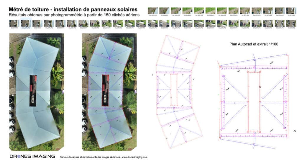
Roof measurements: results obtained from 400 aerial shots on two separate buildings. Service carried out for the study of a future photovoltaic panels instllation.

Orthophoto and measurements

Roof measurement

Orthophoto and measurements

Métré de toiture

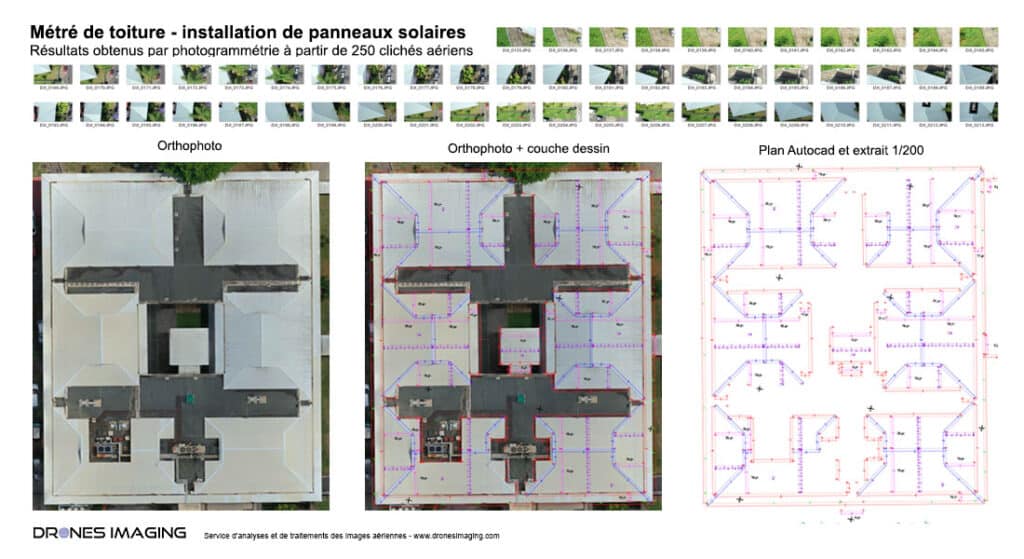
Service carried out in two stages where the first stage, thanks to photogrammetry software, consists of generating a digital twin of the building to scale, therefore measurable with centimeter accuracy.

Thanks to the 3D model thus built, it is possible to record all the quotations requested by the design office in charge of sizing the future solar installation. Concerning the two use cases presented above, the measurement work includes the various calculations of projected distances, real distances, projected and real surfaces as well as the various inclinations of the sections making it possible to precisely simulate the quantities of photovoltaic panels to be install (according to solar inclination). In addition, all of the surrounding elements (vegetation, superstructures or infrastructures) that could affect the performance of the future installation through cast shadows are also reported and mentioned. They are an integral part of the quantity survey and very useful for simulating future electrical performance.

TECHNICAL INFORMATIONS

  • Imagery processing and analysis service : Drones Imaging company.
  • Flights and aerial imagery captation : Air Drone Multi-Services company.
  • Spatial accuracy : centimeter with EMLID Reach RS2+ RTK receiver
  • Orthophoto RVB : GSD 8mm.
  • Drone : Phantom 4 pro RTK.
  • Photogrammetry software : Agisoft Metashape.
  • Export formats : GéoTiff and Dwg autocad.
  • Delivery delay : 1 day.
PrevPrécédentTopographic map of a tourist complex in Corsica
SuivantRevegetation percentage calculation for an ecological restoration projectNext
  • Mentions légales
  • FrançaisFrançais
  • EnglishEnglish