Skip to content
Services et traitements des images aériennes
Twitter Facebook Linkedin
  • Français
  • English
DRONES IMAGING
  • Drones imaging
    • Who are we
  • images processing service
    • topographic service
    • thermographic service
    • agricultural service
    • automatic counting service
    • Use case
    • Product sheets
    • useful documentation
    • download guide
  • Trainings
    • training in photogrammetry metashape option
    • training in photogrammetry Pix4D option
    • Multispectral training
    • online photogrammetry training
  • Softwares
    • Agisoft Metashape photogrammetry software
    • Undet software
  • RTK Receivers
    • EMLID GNSS RTK Reach RS3
    • EMLID GNSS RTK Reach RS2+
    • Emlid GNSS RTK Reach RX
    • EMLID GNSS RTK Reach RS+
  • Sensors
    • Agrowing Multispectral cameras
  • News
  • Contact us
  • Toggle website search
Menu Close
  • Drones imaging
    • Who are we
  • images processing service
    • topographic service
    • thermographic service
    • agricultural service
    • automatic counting service
    • Use case
    • Product sheets
    • useful documentation
    • download guide
  • Trainings
    • training in photogrammetry metashape option
    • training in photogrammetry Pix4D option
    • Multispectral training
    • online photogrammetry training
  • Softwares
    • Agisoft Metashape photogrammetry software
    • Undet software
  • RTK Receivers
    • EMLID GNSS RTK Reach RS3
    • EMLID GNSS RTK Reach RS2+
    • Emlid GNSS RTK Reach RX
    • EMLID GNSS RTK Reach RS+
  • Sensors
    • Agrowing Multispectral cameras
  • News
  • Contact us
  • Toggle website search

Blog

  1. Home>
  2. geomatics>
  3. Topographic survey made from open source imagery.

Topographic survey made from open source imagery.

  • June 24, 2016
  • 7:22 pm

Open-source 3D modeling.

Open-source 3D modeling: Topographic survey & 3D modeling of Castle Island made using satellite imagery from Google Earth.

3D modeling of Castle Island

Open-source 3D modeling

3D visualization of Castle Island

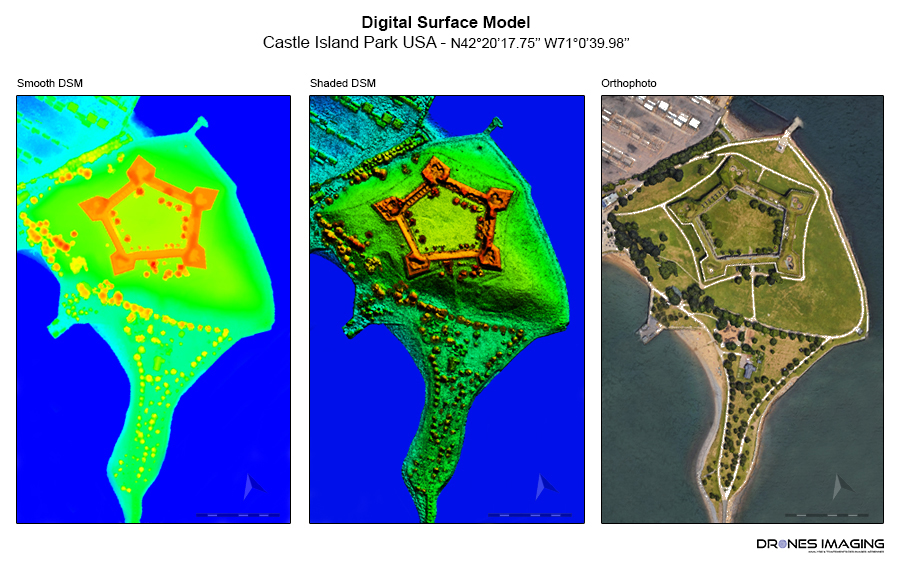
Castle Island is a former island attached to the American continent since 1928. Located on Day Boulevard south of Boston, it was the subject of a star fortification in 1634.

TECHNICAL INFORMATIONS

  • Aerial imagery post-processing service : Drones Imaging company.
  • Aerial imagery : Google Earth.
  • Spatial accuracy : metric.
  • Airborne platform : satellite.
  • Photogrammetry software : Agisoft Metashape.
  • Completion time : 02h30.
  • Use case taught during our photogrammetry training : see more.
PrevPrécédentSurvey plan and volumetric calculations produced by aerial photogrammetry.
SuivantTraining in remote piloting applied to photogrammetry: facade inspectionNext
  • Mentions légales
  • Français
  • English