Skip to content
Services et traitements des images aériennes
Twitter Facebook Linkedin
  • Français
  • English
DRONES IMAGING
  • Drones imaging
    • Who are we
  • images processing service
    • topographic service
    • thermographic service
    • agricultural service
    • automatic counting service
    • Use case
    • Product sheets
    • useful documentation
    • download guide
  • Trainings
    • training in photogrammetry metashape option
    • training in photogrammetry Pix4D option
    • Multispectral training
    • online photogrammetry training
  • Softwares
    • Agisoft Metashape photogrammetry software
    • Undet software
  • RTK Receivers
    • EMLID GNSS RTK Reach RS3
    • EMLID GNSS RTK Reach RS2+
    • Emlid GNSS RTK Reach RX
    • EMLID GNSS RTK Reach RS+
  • Sensors
    • Agrowing Multispectral cameras
  • News
  • Contact us
  • Toggle website search
Menu Close
  • Drones imaging
    • Who are we
  • images processing service
    • topographic service
    • thermographic service
    • agricultural service
    • automatic counting service
    • Use case
    • Product sheets
    • useful documentation
    • download guide
  • Trainings
    • training in photogrammetry metashape option
    • training in photogrammetry Pix4D option
    • Multispectral training
    • online photogrammetry training
  • Softwares
    • Agisoft Metashape photogrammetry software
    • Undet software
  • RTK Receivers
    • EMLID GNSS RTK Reach RS3
    • EMLID GNSS RTK Reach RS2+
    • Emlid GNSS RTK Reach RX
    • EMLID GNSS RTK Reach RS+
  • Sensors
    • Agrowing Multispectral cameras
  • News
  • Contact us
  • Toggle website search

Yearly Archives: 2015

  1. Home>
  2. 2015
3d pic midi ossau

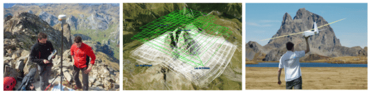
3D modeling of the Pic du Midi d’Ossau...

  • geomatics
  • December 23, 2015
3D modeling by photogrammetry of the Pic du midi d’Ossau. 3D modeling by photogrammetry of the Pic du midi
Continuer la lecture
plan topographique

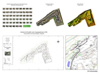
Topographic plans drawing service for mines and quarries

  • geomatics
  • December 1, 2015
regulatory survey plan for quarry management Regulatory survey plan: In order to respond to the mining industry markets, Drones
Continuer la lecture
inspection cheminée

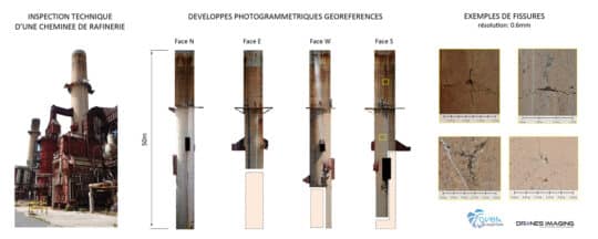
Technical inspection of a refinery performed by drone

  • geomatics
  • October 25, 2015
Inspection of a cracking tower and detection of disorders Inspection of a cracking tower: Photogrammetry views of the 4
Continuer la lecture
Inspection pont

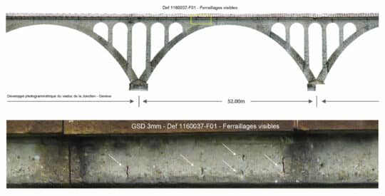
Engineering structure inspection by drone

  • geomatics
  • September 18, 2015
Inspection of the Jonction viaduct in Geneva Viaduct inspection: photogrammetric restitution of the downstream and upstream facings of the
Continuer la lecture
3D Syrie Palmyre

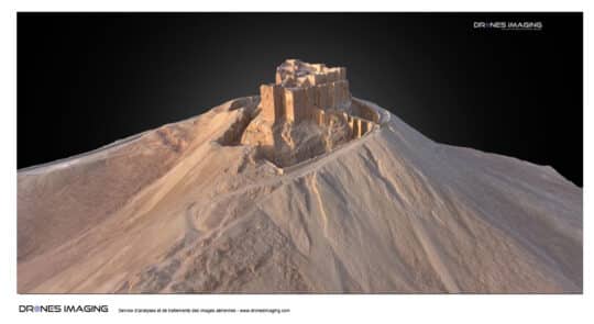
Preservation of the cultural heritage of Palmyra –...

  • geomatics
  • June 11, 2015
Go back in time in Palmyra 3D Go back in time in 3D immersion around the castle of Palmyra.
Continuer la lecture
3D Katmandou

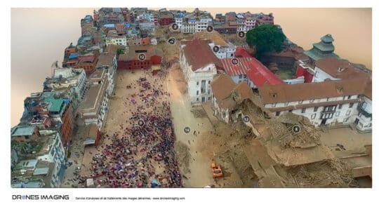
Earthquake in Nepal – 3D modeling of Basantapur...

  • geomatics
  • April 27, 2015
Earthquake in Nepal – 3D modeling of Durbar Square in Kathmandu Earthquake in Nepal, 3D modeling of downtown Kathmandu.
Continuer la lecture
simulation inondation

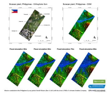
Bulacan, Philippines – a drone for study industrial...

  • geomatics
  • February 15, 2015
Flood risk prevention at a cement factory. Flood risk Prevention at the Holcim industrial site in the Philippines. Work
Continuer la lecture
  • Mentions légales
  • Français
  • English