Skip to content
Services et traitements des images aériennes
Twitter Facebook Linkedin
  • Français
  • English
DRONES IMAGING
  • Drones imaging
    • Who are we
  • images processing service
    • topographic service
    • thermographic service
    • agricultural service
    • automatic counting service
    • Use case
    • Product sheets
    • useful documentation
    • download guide
  • Trainings
    • training in photogrammetry metashape option
    • training in photogrammetry Pix4D option
    • Multispectral training
    • online photogrammetry training
  • Softwares
    • Agisoft Metashape photogrammetry software
    • Undet software
  • RTK Receivers
    • EMLID GNSS RTK Reach RS3
    • EMLID GNSS RTK Reach RS2+
    • Emlid GNSS RTK Reach RX
    • EMLID GNSS RTK Reach RS+
  • Sensors
    • Agrowing Multispectral cameras
  • News
  • Contact us
  • Toggle website search
Menu Close
  • Drones imaging
    • Who are we
  • images processing service
    • topographic service
    • thermographic service
    • agricultural service
    • automatic counting service
    • Use case
    • Product sheets
    • useful documentation
    • download guide
  • Trainings
    • training in photogrammetry metashape option
    • training in photogrammetry Pix4D option
    • Multispectral training
    • online photogrammetry training
  • Softwares
    • Agisoft Metashape photogrammetry software
    • Undet software
  • RTK Receivers
    • EMLID GNSS RTK Reach RS3
    • EMLID GNSS RTK Reach RS2+
    • Emlid GNSS RTK Reach RX
    • EMLID GNSS RTK Reach RS+
  • Sensors
    • Agrowing Multispectral cameras
  • News
  • Contact us
  • Toggle website search

Blog

  1. Home>
  2. geomatics>
  3. Topographic plans drawing service for mines and quarries

Topographic plans drawing service for mines and quarries

  • December 1, 2015
  • 7:52 am

regulatory survey plan for quarry management

Regulatory survey plan: In order to respond to the mining industry markets, Drones Imaging is launching its new producing and editing Autocad topographic plans service for companies specializing in aerial works. Below is the first extract from deliverable provided on Chuzelle’s quarry in collaboration with the company Infratech for flights, aerial images capture and target survey part.

Extract from Autocad survey map

Regulatory survey plan

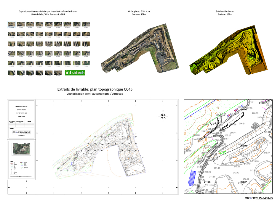
Quarry topographic survey, December 2015. Result obtained from 1440 aerial images captured by the company Infratech, VRD design office specializing in aerial work with drones. Above, the orthophoto and digital surface model built by photogrammetry from 1440 images made it possible to produce and deliver a regulatory survey plan whose spatial accuracy is less than 4cm (in planimetry and altimetry).

TECHNICAL INFORMATIONS

  • Image processing & analysis service for mining industry : Drones Imaging company.
  • Flights and aerial imagery : Infratech company.
  • Spatial accuracy : centimeter.
  • Orthophoto RVB : GSD 3cm.
  • Covered area : 10ha.
  • Drone : DJI S1000.
  • Camera : DMC GH4.
  • Photogrammetry software : Metashape.
  • Export formats : GeoTiff, Pdf and Dwg autocad.
  • Delivery delay : 2 days.
PrevPrécédentTechnical inspection of a refinery performed by drone
Suivant3D modeling of the Pic du Midi d’Ossau on the occasion of the 70th anniversary of the UNGE (National Union of Expert Surveyors).Next
  • Mentions légales
  • Français
  • English