Skip to content
Services et traitements des images aériennes
Twitter Facebook Linkedin
  • Français
  • English
DRONES IMAGING
  • Drones imaging
    • Who are we
  • images processing service
    • topographic service
    • thermographic service
    • agricultural service
    • automatic counting service
    • Use case
    • Product sheets
    • useful documentation
    • download guide
  • Trainings
    • training in photogrammetry metashape option
    • training in photogrammetry Pix4D option
    • Multispectral training
    • online photogrammetry training
  • Softwares
    • Agisoft Metashape photogrammetry software
    • Undet software
  • RTK Receivers
    • EMLID GNSS RTK Reach RS3
    • EMLID GNSS RTK Reach RS2+
    • Emlid GNSS RTK Reach RX
    • EMLID GNSS RTK Reach RS+
  • Sensors
    • Agrowing Multispectral cameras
  • News
  • Contact us
  • Toggle website search
Menu Close
  • Drones imaging
    • Who are we
  • images processing service
    • topographic service
    • thermographic service
    • agricultural service
    • automatic counting service
    • Use case
    • Product sheets
    • useful documentation
    • download guide
  • Trainings
    • training in photogrammetry metashape option
    • training in photogrammetry Pix4D option
    • Multispectral training
    • online photogrammetry training
  • Softwares
    • Agisoft Metashape photogrammetry software
    • Undet software
  • RTK Receivers
    • EMLID GNSS RTK Reach RS3
    • EMLID GNSS RTK Reach RS2+
    • Emlid GNSS RTK Reach RX
    • EMLID GNSS RTK Reach RS+
  • Sensors
    • Agrowing Multispectral cameras
  • News
  • Contact us
  • Toggle website search

Blog

  1. Home>
  2. geomatics>
  3. Aerial mapping and topographic survey of a photovoltaic power plant – French Guiana.

Aerial mapping and topographic survey of a photovoltaic power plant – French Guiana.

  • December 13, 2016
  • 12:35 pm

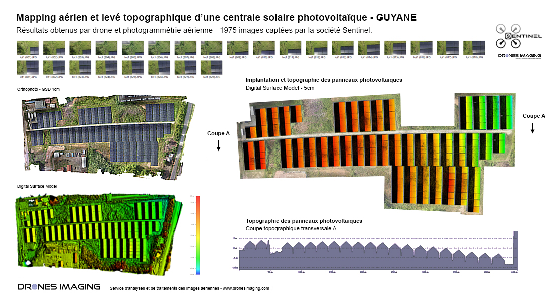
Topographical survey of a solar power plant in French Guyana

Topographical survey of a solar power plant and visual inspection of the photovoltaic panels. Results obtained from 1975 aerial photos taken by Sentinel. Post-processing and data analysis by Drones Imaging.

Orthophoto and Digital Surface Model

Topographical survey of a solar power plant

3D visualization of the solar farm

Topographic survey carried out by aerial photogrammetry and delivered in the form of an orthophoto + dense cloud. Compatible with Autocad, this geospatial data are using to elaborate a topographic and legal plan of the site. The very high resolution orthomosaic also allowed visual inspection of each panel.

TECHNICAL INFORMATIONS

  • Aerial imagery post-processing service : Drones Imaging company.
  • Aerial imagery capture : Sentinel company.
  • Spatial accuracy : centimeter.
  • Orthophoto RVB : GSD 5mm.
  • Inspected area : 10ha.
  • Photogrammetry software : Agisoft Metashape.
  • Export formats : GéoTiff and Dwg autocad.
  • Delivery delay : 4 hours.
  • Use case taught during our photogrammetry training  : see more.
PrevPrécédentTopographic survey and roofs inspection
SuivantThermal inspection by photogrammetry – Paris City Hall.Next
  • Mentions légales
  • Français
  • English