Skip to content
Services et traitements des images aériennes
Twitter Facebook Linkedin
  • Français
  • English
DRONES IMAGING
  • Drones imaging
    • Who are we
  • images processing service
    • topographic service
    • thermographic service
    • agricultural service
    • automatic counting service
    • Use case
    • Product sheets
    • useful documentation
    • download guide
  • Trainings
    • training in photogrammetry metashape option
    • training in photogrammetry Pix4D option
    • Multispectral training
    • online photogrammetry training
  • Softwares
    • Agisoft Metashape photogrammetry software
    • Undet software
  • RTK Receivers
    • EMLID GNSS RTK Reach RS3
    • EMLID GNSS RTK Reach RS2+
    • Emlid GNSS RTK Reach RX
    • EMLID GNSS RTK Reach RS+
  • Sensors
    • Agrowing Multispectral cameras
  • News
  • Contact us
  • Toggle website search
Menu Close
  • Drones imaging
    • Who are we
  • images processing service
    • topographic service
    • thermographic service
    • agricultural service
    • automatic counting service
    • Use case
    • Product sheets
    • useful documentation
    • download guide
  • Trainings
    • training in photogrammetry metashape option
    • training in photogrammetry Pix4D option
    • Multispectral training
    • online photogrammetry training
  • Softwares
    • Agisoft Metashape photogrammetry software
    • Undet software
  • RTK Receivers
    • EMLID GNSS RTK Reach RS3
    • EMLID GNSS RTK Reach RS2+
    • Emlid GNSS RTK Reach RX
    • EMLID GNSS RTK Reach RS+
  • Sensors
    • Agrowing Multispectral cameras
  • News
  • Contact us
  • Toggle website search

Blog

  1. Home>
  2. geomatics>
  3. Dam inspection – Topographic survey and disorders detection made by drone and aerial photogrammetry

Dam inspection – Topographic survey and disorders detection made by drone and aerial photogrammetry

  • March 1, 2021
  • 1:51 pm

Dam inspection carried out by drone and photogrammetry.

Results obtained from 1826 aerial images over a 4840m² area.

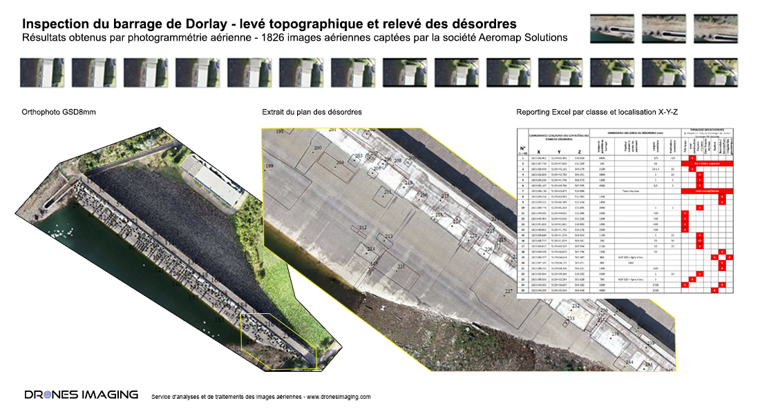
Defects map made on the upstream face of the dam

Dam inspection by drone

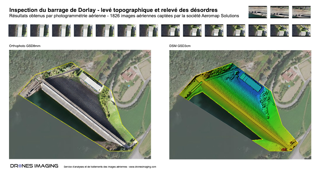
Orthophoto of the Dorlay dam (Loire department), september 2020. Work made from 1826 aerial images taken by Aeromap Solutions, drone operator specializing in construction and technical inspections of engineering works. Post-processing by Drones Imaging.

On this structure, the orthophoto of the upstream facing (face facing south-west) allowed, by surface clipping, the georeferenced detection of all the disorders required by the specifications:

  • Cracking.
  • Construction joints.
  • Crack <0.5mm.
  • Crack >0.5mm.
  • Patches.
  • Beads.
  • Geometric irregularities.

With variable surfaces, the polygons detected by photo-interpretation and sometimes overlapping each other on the upstream face, a calculation of the centroids made it possible to reduce the positive surfaces to unique geolocated points selectable by attribute class of disorders. Thus allowing, subsequently, to export an Excel workbook listing all the defects by class but also by location XYZ / NGF -General level of France thus offering the end customer a spreadsheet summarizing this inspection service for optimal management of their datas (as illustrated below).

Dam inspection by drone

TECHNICAL INFORMATIONS

  • Processing and geomatics service : Drones Imaging company
  • Flights and aerial image source : Aeromap Solutions company
  • Spatial accuracy: centimeter with EMLID Reach RS2
  • Orthophoto : GSD 8mm
  • Total inspected area : 4840m²
  • Drone : DJI P4P
  • Camera : FC6310
  • Photogrammetry software : Metashape
  • Deliverables formats : Autocad plans in Dwg and Pdf formats and defect spreadsheet in Excel formats
PrevPrécédentMinistry of the Armed Forces – Training course in photogrammetry option Building Information Model BIM
SuivantMachine learning – automatic counting and spatial distribution of olive trees in a 13ha orchard in Andalusia.Next
  • Mentions légales
  • Français
  • English