Skip to content
Services et traitements des images aériennes
Twitter Facebook Linkedin
  • Français
  • English
DRONES IMAGING
  • Drones imaging
    • Who are we
  • images processing service
    • topographic service
    • thermographic service
    • agricultural service
    • automatic counting service
    • Use case
    • Product sheets
    • useful documentation
    • download guide
  • Trainings
    • training in photogrammetry metashape option
    • training in photogrammetry Pix4D option
    • Multispectral training
    • online photogrammetry training
  • Softwares
    • Agisoft Metashape photogrammetry software
    • Undet software
  • RTK Receivers
    • EMLID GNSS RTK Reach RS3
    • EMLID GNSS RTK Reach RS2+
    • Emlid GNSS RTK Reach RX
    • EMLID GNSS RTK Reach RS+
  • Sensors
    • Agrowing Multispectral cameras
  • News
  • Contact us
  • Toggle website search
Menu Close
  • Drones imaging
    • Who are we
  • images processing service
    • topographic service
    • thermographic service
    • agricultural service
    • automatic counting service
    • Use case
    • Product sheets
    • useful documentation
    • download guide
  • Trainings
    • training in photogrammetry metashape option
    • training in photogrammetry Pix4D option
    • Multispectral training
    • online photogrammetry training
  • Softwares
    • Agisoft Metashape photogrammetry software
    • Undet software
  • RTK Receivers
    • EMLID GNSS RTK Reach RS3
    • EMLID GNSS RTK Reach RS2+
    • Emlid GNSS RTK Reach RX
    • EMLID GNSS RTK Reach RS+
  • Sensors
    • Agrowing Multispectral cameras
  • News
  • Contact us
  • Toggle website search

Blog

  1. Home>
  2. geomatics>
  3. Mapping and topographic survey by drone – Cormeilles circuit

Mapping and topographic survey by drone – Cormeilles circuit

  • February 17, 2017
  • 10:57 am

Topographic analysis of the RKC karting circuit tracks

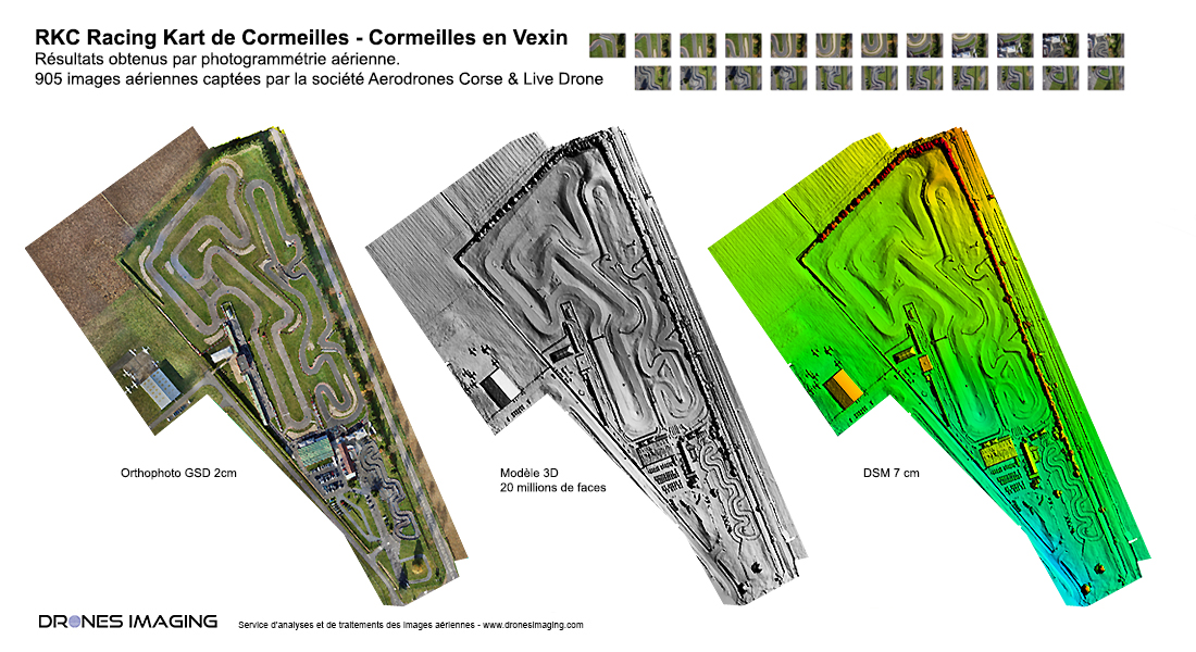
Topographic analysis and Autocad plan made from DSM (Digital Surface Model) and orthophoto on a 15ha area. Results obtained from 905 aerial images taken by the company Aérodronescorse. Aerial image post-processing service by Drones Imaging.

Orthophoto, 3D Model and Digital Surface Model

Topographic analysis

3D visualization of the RKC karting circuit

Topographical analysis of the ccircuit tracks carried out in the form of longitudinal and transverse profiles (by tench of 40cm). Compatible with Autocad Covadis, the geospatial data thus built (MNS and Orthophoto) will later be used to produce the topographic plan necessary for the study of future expansion work.

TECHNICAL INFORMATIONS

  • Post-processing service : Drones Imaging company.
  • Flights and aerial imagery captation : Aerodroescorse company.
  • Spatial accuracy : centimeter.
  • Orthophoto RVB : GSD 1cm.
  • Covered area : 14.3ha.
  • Drone : Mikrokopter.
  • Camera : Sony A7R.
  • 3D modeling software : Agisoft Metashape.
  • Delivery delay : 24h00.
  • Use case taught during our photogrammetry training : see more.
PrevPrécédentOpen source 3D modeling – Paris Charles de Gaulle Airport.
SuivantTopographic survey of the dykes at the Bastia port.Next
  • Mentions légales
  • Français
  • English