Automatic Detection of Grapevines on a plot in Australia
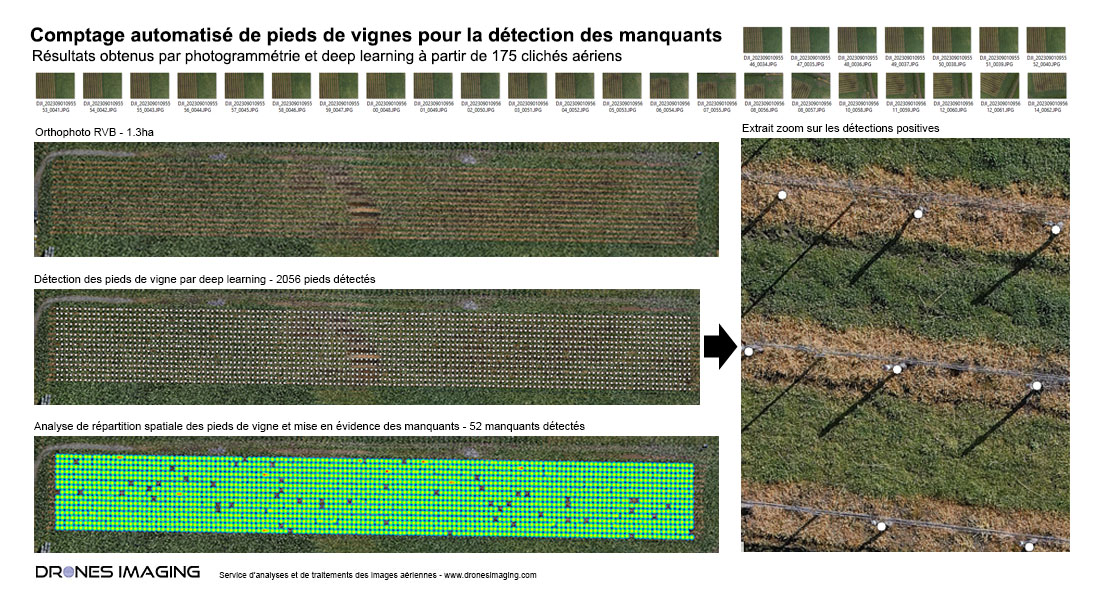
Automatic Detection of Grapevines and Missing Ones on a vineyard plot: Results obtained through photogrammetry and deep learning from 175 aerial images captured by the company Drone Boss. Post-processing and analysis by Drones Imaging.
The wine industry, although traditional, is now embracing a technological revolution: automatic grapevine detection through deep learning. Combined with the use of drones for aerial image capture, this advancement promises more precise vineyard management and a step closer to automation.
The process begins with the capture of hundreds of aerial images of the vineyard from all angles using a drone, covering approximately 1 hectare in just 5 minutes. These sub-centimeter-resolution images capture every detail of the grapevines. Subsequently, a specially trained deep learning model for vine detection analyzes the orthophoto built through photogrammetry, taking into account their size, shape, and color.
Below is the mapping of the 2056 detected grapevines through deep learning and, as an extension (after analyzing planting density), the location of 52 missing vines.
Automatic detection of the 2056 plants and density calculation for locating the missing ones
The advantages of this technology are numerous:
Precision and Speed: Deep learning algorithms offer high accuracy and can cover vast vineyard expanses in record time.
Time and Labor Savings: Automatic detection significantly reduces the time and human resources required compared to manual counting.
Precise Mapping: Automatic grapevine detection provides centimeter-accurate layout mapping essential for automation and RTK GNSS guidance.
Advanced Data Analysis: Generated data can be imported into Geographic Information Systems (GIS) and analysis software, providing vineyard managers with advanced insights into density and missing vines.
Targeted Time-Based Surveillance: In the form of a customized individual record, the history of each vine can now be stored and accessed in a database (seasonal yields, diseases, fungi, attacks, and more, year after year).
In conclusion, automatic grapevine detection from orthophotos is revolutionizing vineyard management today. This innovation illustrates how the convergence of aerial imaging technology, deep learning, and precision agriculture is transforming a traditional industry into a more sustainable and prosperous venture.
TECHNICAL INFORMATIONS
- Automatic counting service : Drones Imaging company.
- Flights and aerial imagery : Drone Boss company.
- Spatial accuracy : centimeter.
- Number of images : 175.
- Total inspected area : 1.3ha.
- Grape variety: Sangiovese.
- Counted plants: 2056.
- Drone : DJI M300.
- Sensor P1 resolution : 8192×5460.
- Photogrammetry software : Agisoft Metashape.