Skip to content
Services et traitements des images aériennes
Twitter Facebook Linkedin
  • Français
  • English
DRONES IMAGING
  • Drones imaging
    • Who are we
  • images processing service
    • topographic service
    • thermographic service
    • agricultural service
    • automatic counting service
    • Use case
    • Product sheets
    • useful documentation
    • download guide
  • Trainings
    • training in photogrammetry metashape option
    • training in photogrammetry Pix4D option
    • Multispectral training
    • online photogrammetry training
  • Softwares
    • Agisoft Metashape photogrammetry software
    • Undet software
  • RTK Receivers
    • EMLID GNSS RTK Reach RS3
    • EMLID GNSS RTK Reach RS2+
    • Emlid GNSS RTK Reach RX
    • EMLID GNSS RTK Reach RS+
  • Sensors
    • Agrowing Multispectral cameras
  • News
  • Contact us
  • Toggle website search
Menu Close
  • Drones imaging
    • Who are we
  • images processing service
    • topographic service
    • thermographic service
    • agricultural service
    • automatic counting service
    • Use case
    • Product sheets
    • useful documentation
    • download guide
  • Trainings
    • training in photogrammetry metashape option
    • training in photogrammetry Pix4D option
    • Multispectral training
    • online photogrammetry training
  • Softwares
    • Agisoft Metashape photogrammetry software
    • Undet software
  • RTK Receivers
    • EMLID GNSS RTK Reach RS3
    • EMLID GNSS RTK Reach RS2+
    • Emlid GNSS RTK Reach RX
    • EMLID GNSS RTK Reach RS+
  • Sensors
    • Agrowing Multispectral cameras
  • News
  • Contact us
  • Toggle website search

Yearly Archives: 2022

  1. Home>
  2. 2022
Restauration écologique par drone

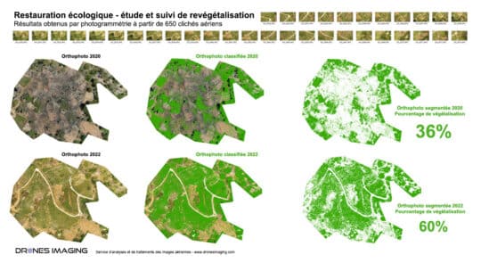
Revegetation percentage calculation for an ecological restoration project

  • geomatics
  • October 5, 2022
Ecological restoration and calculation of revegetation percentage made by drone Ecological restoration: results obtained from 1187 aerial images taken
Continuer la lecture

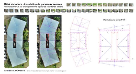
Complex roof survey carried out by drone

  • geomatics
  • September 29, 2022
Roof measurements: Autocad plan built by drone and aerial photogrammetry. Roof measurements: results obtained from 400 aerial shots on
Continuer la lecture

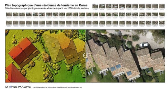
Topographic map of a tourist complex in Corsica

  • geomatics
  • July 25, 2022
Autocad plan built by photogrammetry from aerial images. Results obtained from 1050 aerial images over a 5ha total area
Continuer la lecture

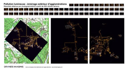
Study of light pollution for energy waste and...

  • geomatics
  • May 4, 2022
Light pollution – nocturnal orthophoto made by aerial photogrammetry Results obtained from 650 aerial images over a 22km² area
Continuer la lecture
Inspection d'ouvrage d'art

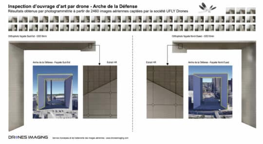
Inspection of engineering works carried out by drone...

  • geomatics
  • March 11, 2022
Sub-millimeter orthofacades of the Arche de la Défense vertical walls Results obtained from 2640 aerial images taken by the
Continuer la lecture
  • Mentions légales
  • Français
  • English