Skip to content
Services et traitements des images aériennes
Twitter Facebook Linkedin
  • Français
  • English
DRONES IMAGING
  • Drones imaging
    • Who are we
  • images processing service
    • topographic service
    • thermographic service
    • agricultural service
    • automatic counting service
    • Use case
    • Product sheets
    • useful documentation
    • download guide
  • Trainings
    • training in photogrammetry metashape option
    • training in photogrammetry Pix4D option
    • Multispectral training
    • online photogrammetry training
  • Softwares
    • Agisoft Metashape photogrammetry software
    • Undet software
  • RTK Receivers
    • EMLID GNSS RTK Reach RS3
    • EMLID GNSS RTK Reach RS2+
    • Emlid GNSS RTK Reach RX
    • EMLID GNSS RTK Reach RS+
  • Sensors
    • Agrowing Multispectral cameras
  • News
  • Contact us
  • Toggle website search
Menu Close
  • Drones imaging
    • Who are we
  • images processing service
    • topographic service
    • thermographic service
    • agricultural service
    • automatic counting service
    • Use case
    • Product sheets
    • useful documentation
    • download guide
  • Trainings
    • training in photogrammetry metashape option
    • training in photogrammetry Pix4D option
    • Multispectral training
    • online photogrammetry training
  • Softwares
    • Agisoft Metashape photogrammetry software
    • Undet software
  • RTK Receivers
    • EMLID GNSS RTK Reach RS3
    • EMLID GNSS RTK Reach RS2+
    • Emlid GNSS RTK Reach RX
    • EMLID GNSS RTK Reach RS+
  • Sensors
    • Agrowing Multispectral cameras
  • News
  • Contact us
  • Toggle website search

Blog

  1. Home>
  2. geomatics>
  3. Game damage diagnosis carried out by drone

Game damage diagnosis carried out by drone

  • November 23, 2016
  • 12:05 pm

Game damage mapping

Game damage mapping carried out on a corn plot in Montargis. November 2016. Results obtained from 1040 aerial shots taken by the company Marceau Drone Images. Analysis and post-processing service by Drones Imaging.

Assessment of game damage by drone

Game damage mapping

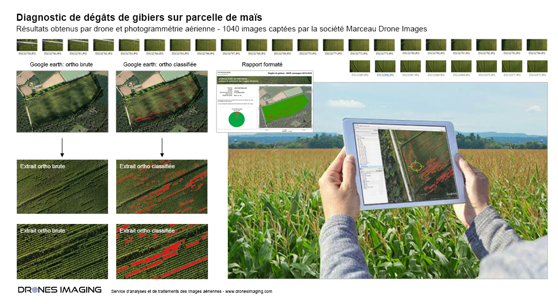
With this use case, the very high resolution orthophoto allows precise classification of surfaces damaged by game. The results are then delivered in the form of a summary report and the established diagnosis allows optimal compensation of the owner.

Compatible and viewable with google earth, the mapping of damaged surfaces (coupled with the GPS of a tablet or smartphone) also helps guide the expert for clearing up doubts or checking directly on the field.

TECHNICAL INFORMATIONS

  • Image processing service applied to the agricultural field : société Drones Imaging company.
  • Flights and aerial imagery : Marceau Drone Images company.
  • Spatial accuracy : relative centimeter.
  • Orthophoto RVB : GSD 1cm.
  • Inspected area : 14ha.
  • Drone : Mikrokopter.
  • Sensor : SONY A6000.
  • Photogrammetry software : Metashape.
  • Geographic Information System : ArcGis.
  • Export formats : Csv Xls, Pdf and Kmz.
  • Delivery times upon receipt of images : 48h00.
PrevPrécédentDrone roof inspections – Avoriaz
SuivantTopographic survey and roofs inspectionNext
  • Mentions légales
  • Français
  • English