Skip to content
Services et traitements des images aériennes
Twitter Facebook Linkedin
  • Français
  • English
DRONES IMAGING
  • Drones imaging
    • Who are we
  • images processing service
    • topographic service
    • thermographic service
    • agricultural service
    • automatic counting service
    • Use case
    • Product sheets
    • useful documentation
    • download guide
  • Trainings
    • training in photogrammetry metashape option
    • training in photogrammetry Pix4D option
    • Multispectral training
    • online photogrammetry training
  • Softwares
    • Agisoft Metashape photogrammetry software
    • Undet software
  • RTK Receivers
    • EMLID GNSS RTK Reach RS3
    • EMLID GNSS RTK Reach RS2+
    • Emlid GNSS RTK Reach RX
    • EMLID GNSS RTK Reach RS+
  • Sensors
    • Agrowing Multispectral cameras
  • News
  • Contact us
  • Toggle website search
Menu Close
  • Drones imaging
    • Who are we
  • images processing service
    • topographic service
    • thermographic service
    • agricultural service
    • automatic counting service
    • Use case
    • Product sheets
    • useful documentation
    • download guide
  • Trainings
    • training in photogrammetry metashape option
    • training in photogrammetry Pix4D option
    • Multispectral training
    • online photogrammetry training
  • Softwares
    • Agisoft Metashape photogrammetry software
    • Undet software
  • RTK Receivers
    • EMLID GNSS RTK Reach RS3
    • EMLID GNSS RTK Reach RS2+
    • Emlid GNSS RTK Reach RX
    • EMLID GNSS RTK Reach RS+
  • Sensors
    • Agrowing Multispectral cameras
  • News
  • Contact us
  • Toggle website search

Blog

  1. Home>
  2. geomatics>
  3. Bridge inspection by photogrammetry

Bridge inspection by photogrammetry

  • February 3, 2017
  • 10:21 am

Bridge inspection carried out by aerial photogrammetry.

Bridge inspection and 3D modeling of upstream/downstream faces. Results obtained from 520 aerial images taken by AirCity Diagnostic. Post-processing service by Drones Imaging.

Structure inspection by drone - 3D modeling and orthophotos of downstream & upstream faces

Inspection de pont par drone

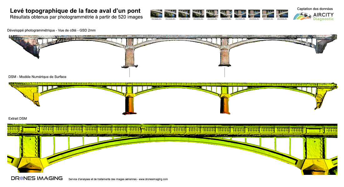
Very high resolution orthophotos of the upstream and downstream faces of the bridge generated for a subsequent walls inspection in the design office (by photo interpretation). In this use case, digital surface model associated with the upstream and downstream faces makes it possible to immediately isolate any severe pathologies such as “bursts” or “structural deformations”.

TECHNICAL INFORMATIONS

  • Aerial imagery processing service : Drones Imaging company.
  • Aerial captation : Air City Diagnostic company.
  • Spatial accuracy : centimeter.
  • Bridge length : 170m.
  • Orthophotos : 2mm GSD.
  • Drone : MikroKopter.
  • Camera : Sony A6000.
  • Photogrammetry software : Metashape.
  • Export formats : GeoTiff and DWG Autocad.
  • Delivery delay : 24 hours.
  • Use cases taught during our photogrammetry training sessions : see more.
PrevPrécédentThermal inspection by photogrammetry – Paris City Hall.
SuivantOpen source 3D modeling – Paris Charles de Gaulle Airport.Next
  • Mentions légales
  • Français
  • English