Skip to content
Services et traitements des images aériennes
Twitter Facebook Linkedin
  • Français
  • English
DRONES IMAGING
  • Drones imaging
    • Who are we
  • images processing service
    • topographic service
    • thermographic service
    • agricultural service
    • automatic counting service
    • Use case
    • Product sheets
    • useful documentation
    • download guide
  • Trainings
    • training in photogrammetry metashape option
    • training in photogrammetry Pix4D option
    • Multispectral training
    • online photogrammetry training
  • Softwares
    • Agisoft Metashape photogrammetry software
    • Undet software
  • RTK Receivers
    • EMLID GNSS RTK Reach RS3
    • EMLID GNSS RTK Reach RS2+
    • Emlid GNSS RTK Reach RX
    • EMLID GNSS RTK Reach RS+
  • Sensors
    • Agrowing Multispectral cameras
  • News
  • Contact us
  • Toggle website search
Menu Close
  • Drones imaging
    • Who are we
  • images processing service
    • topographic service
    • thermographic service
    • agricultural service
    • automatic counting service
    • Use case
    • Product sheets
    • useful documentation
    • download guide
  • Trainings
    • training in photogrammetry metashape option
    • training in photogrammetry Pix4D option
    • Multispectral training
    • online photogrammetry training
  • Softwares
    • Agisoft Metashape photogrammetry software
    • Undet software
  • RTK Receivers
    • EMLID GNSS RTK Reach RS3
    • EMLID GNSS RTK Reach RS2+
    • Emlid GNSS RTK Reach RX
    • EMLID GNSS RTK Reach RS+
  • Sensors
    • Agrowing Multispectral cameras
  • News
  • Contact us
  • Toggle website search

Blog

  1. Home>
  2. geomatics>
  3. Revegetation percentage calculation for an ecological restoration project

Revegetation percentage calculation for an ecological restoration project

  • October 5, 2022
  • 12:59 pm

Ecological restoration and calculation of revegetation percentage made by drone

Ecological restoration: results obtained from 1187 aerial images taken by Tech Drone Service company. Post-processing and data analysis by Drones Imaging.

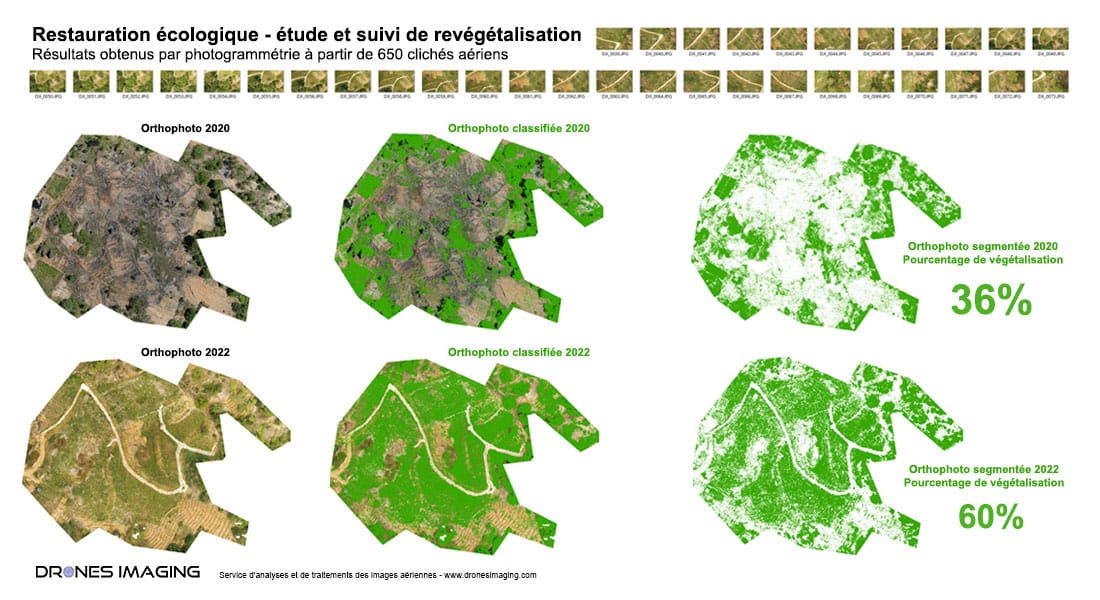
Calculation of revegetation percentage on a two acres old mining site between 2020 and 2022

Ecological restoration

Ecosystem analysis and monitoring service carried out as part of a pilot project for the restoration of biodiversity on a former mining site.

With this commercial use case and thanks to a recurring drone flight each year, a calculation of the revegetation percentage make it possible to precisely monitor the level of plantations development season after season. Eventually, ecological restoration, also called revegetation, will allow the repair of the ecosystem destroyed by industrial activity. It will also limit the invasion of unwanted plants and limit soil erosion.

According to a study by the United Nations Environment Programme, 40% of the world economy depends on the proper functioning of ecosystems. Their preservation and restoration are therefore a necessity and are part of France’s political commitments, in particular via the national strategy for biodiversity 2011-2020.

TECHNICAL INFORMATIONS

  • Post-processing and data analysis service : Drones Imaging company.
  • Flights and aerial imagery : Tech Drone Service company.
  • Spatial accuracy : centimeter in relative between 2020 and 2022.
  • Orthophoto RVB : GSD 1cm.
  • Covered area : 2ha.
  • Drone : DJI Mavic 2 pro.
  • Sensor : Hasselblad L1D-20c
  • Photogrammetry software : Metashape.
  • Geographic Information System : ArcGis.

PrevPrécédentComplex roof survey carried out by drone
SuivantVisual inspection and safety study of a dam carried out by droneNext
  • Mentions légales
  • Français
  • English