Skip to content
Services et traitements des images aériennes
Twitter Facebook Linkedin
  • Français
  • English
DRONES IMAGING
  • Drones imaging
    • Who are we
  • images processing service
    • topographic service
    • thermographic service
    • agricultural service
    • automatic counting service
    • Use case
    • Product sheets
    • useful documentation
    • download guide
  • Trainings
    • training in photogrammetry metashape option
    • training in photogrammetry Pix4D option
    • Multispectral training
    • online photogrammetry training
  • Softwares
    • Agisoft Metashape photogrammetry software
    • Undet software
  • RTK Receivers
    • EMLID GNSS RTK Reach RS3
    • EMLID GNSS RTK Reach RS2+
    • Emlid GNSS RTK Reach RX
    • EMLID GNSS RTK Reach RS+
  • Sensors
    • Agrowing Multispectral cameras
  • News
  • Contact us
  • Toggle website search
Menu Close
  • Drones imaging
    • Who are we
  • images processing service
    • topographic service
    • thermographic service
    • agricultural service
    • automatic counting service
    • Use case
    • Product sheets
    • useful documentation
    • download guide
  • Trainings
    • training in photogrammetry metashape option
    • training in photogrammetry Pix4D option
    • Multispectral training
    • online photogrammetry training
  • Softwares
    • Agisoft Metashape photogrammetry software
    • Undet software
  • RTK Receivers
    • EMLID GNSS RTK Reach RS3
    • EMLID GNSS RTK Reach RS2+
    • Emlid GNSS RTK Reach RX
    • EMLID GNSS RTK Reach RS+
  • Sensors
    • Agrowing Multispectral cameras
  • News
  • Contact us
  • Toggle website search

Blog

  1. Home>
  2. geomatics>
  3. Agrowing multispectral camera – automatic counting and almonds trees classification in Israel

Agrowing multispectral camera – automatic counting and almonds trees classification in Israel

  • May 12, 2021
  • 6:36 pm

Automatic counting by deep learning.

Results obtained from 155 multispectral images taken by drone over a 18ha area.

Automatic counting and classification of each plantation according to their plant vigor

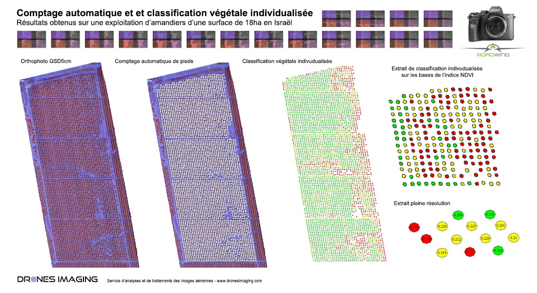
Below are the different stages of a service aimed at mapping each plant according to its plant vigor (according to the NDVI index). Generation of a multispectral orthophoto, automatic counting by deep learning, segmentation and assignment of NDVI value for each plantation.

Automatic counting by deep learning

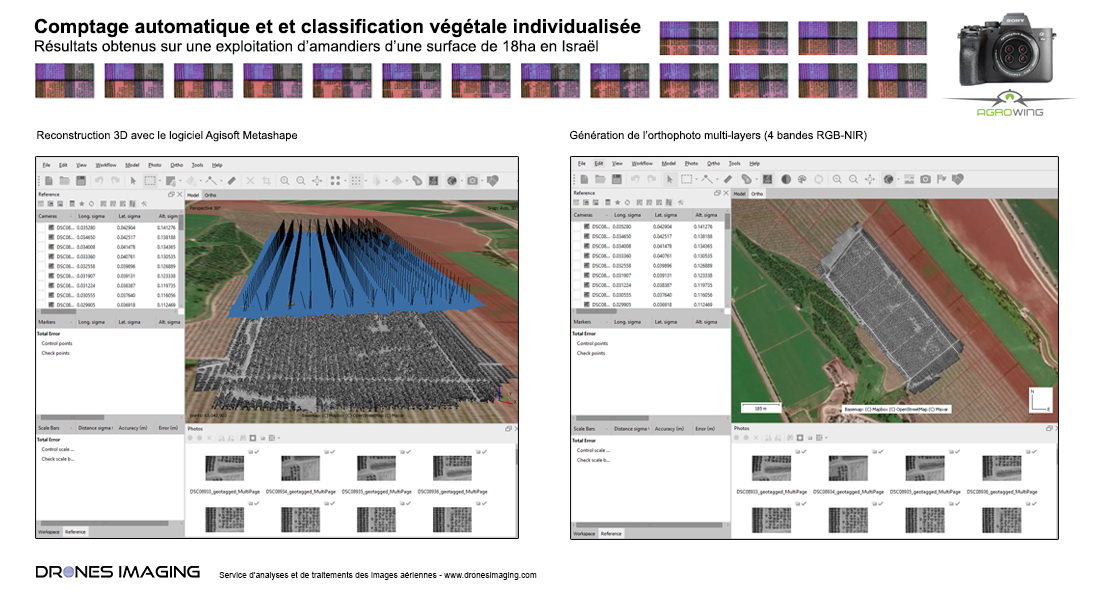
Building geospatial data for automatic counting

As illustrated below with Agisoft Metashape, first step consist in 3D modeling the entire site and then export a multilayer orthophoto with 12 spectral channels (in accordance with the 12 bands generated natively by the A7R4 Quad for each shooting).

Automatic counting by photogrammetry and deep learning

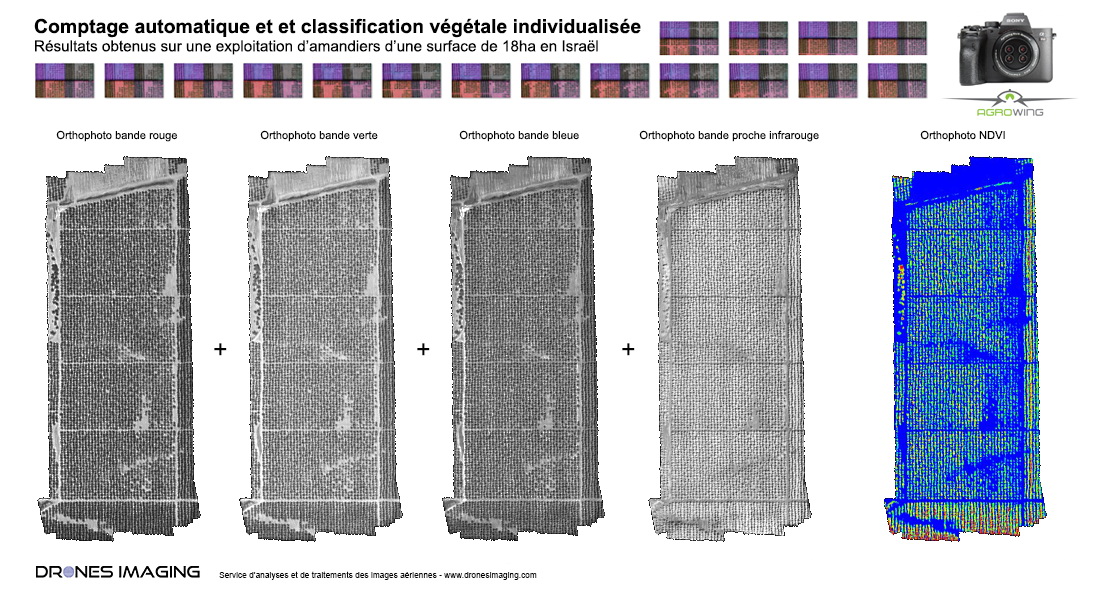
Remote sensing and calculation of the NDVI index for each tree

Through this use case, only just 4 channels are useful: red, green, blue and near infrared. This for the subsequent built of a conventional RGB orthophoto (for visual comfort) and the NDVI index calculation as illustrated below from the red and near infrared channels.

Counting by deep learning

Automatic counting by deep learning: detection and localization

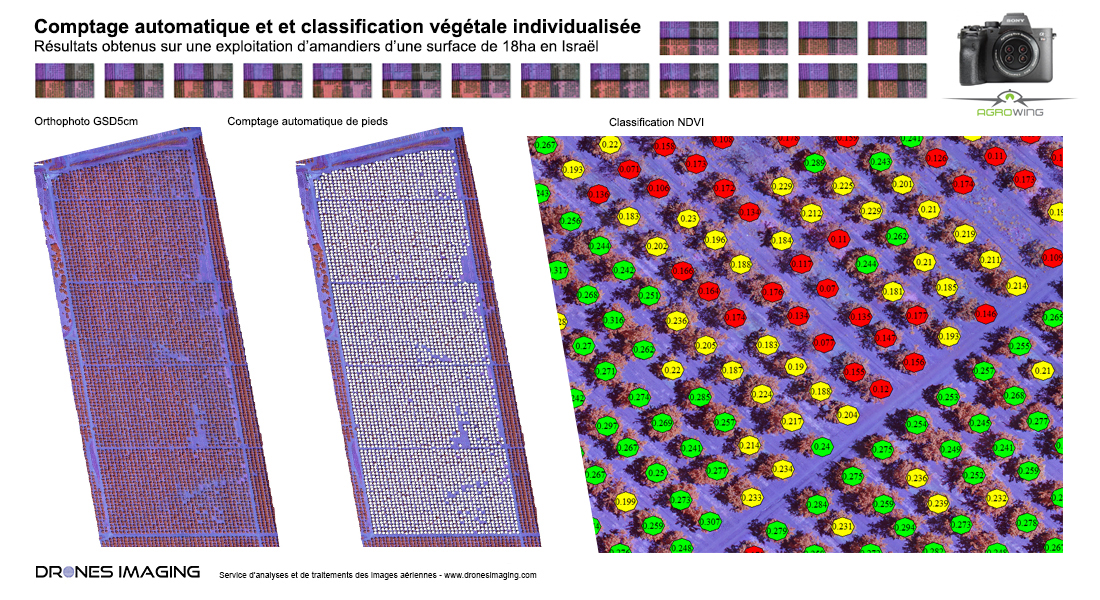
Thanks to the high resolution of this Agrowing sensor, the previously built orthophoto (GSD2cm with a 115m height flight) offer a very high level of details which perfectly reproduce the singular shape of almond trees. In this context, detection by deep learning based on color & shape can be considered.

Once the almond trees are perfectly segmented with respect to each other, a NDVI value can then be assigned locally for each tree.

Automatic counting by deep learning

Conclusion

In addition to its 12 spectral channels dedicated to remote sensing indexes customization, the high resolution of the A7R4 Quad sensor make it possible to generate extremely well detailed NDVI maps but also to enrich them with automatic detection/counting: an unique advantage that meets perfectly to ecological issues and precision farming needs.

TECHNICAL INFORMATIONS

  • Data processing service : Drones Imaging company.
  • Aerial images source : Agrowing company.
  • Multispectral sensor : A7R4 Quad Agrowing.
  • Spatial accuracy : centimeter with the GNSS EMLID Reach RS2 receiver.
  • Orthophoto RVB NIR : 2cm GSD.
  • Covered area : 18ha.
  • Automatic counting : 4131 almond trees counted.
  • Photogrammetry software : Agisoft Metashape.
PrevPrécédentMachine learning – automatic counting and spatial distribution of olive trees in a 13ha orchard in Andalusia.
SuivantSurvey map of a parking area built by drone and aerial photogrammetryNext
  • Mentions légales
  • Français
  • English