Skip to content
Services et traitements des images aériennes
Twitter Facebook Linkedin
  • Français
  • English
DRONES IMAGING
  • Drones imaging
    • Who are we
  • images processing service
    • topographic service
    • thermographic service
    • agricultural service
    • automatic counting service
    • Use case
    • Product sheets
    • useful documentation
    • download guide
  • Trainings
    • training in photogrammetry metashape option
    • training in photogrammetry Pix4D option
    • Multispectral training
    • online photogrammetry training
  • Softwares
    • Agisoft Metashape photogrammetry software
    • Undet software
  • RTK Receivers
    • EMLID GNSS RTK Reach RS3
    • EMLID GNSS RTK Reach RS2+
    • Emlid GNSS RTK Reach RX
    • EMLID GNSS RTK Reach RS+
  • Sensors
    • Agrowing Multispectral cameras
  • News
  • Contact us
  • Toggle website search
Menu Close
  • Drones imaging
    • Who are we
  • images processing service
    • topographic service
    • thermographic service
    • agricultural service
    • automatic counting service
    • Use case
    • Product sheets
    • useful documentation
    • download guide
  • Trainings
    • training in photogrammetry metashape option
    • training in photogrammetry Pix4D option
    • Multispectral training
    • online photogrammetry training
  • Softwares
    • Agisoft Metashape photogrammetry software
    • Undet software
  • RTK Receivers
    • EMLID GNSS RTK Reach RS3
    • EMLID GNSS RTK Reach RS2+
    • Emlid GNSS RTK Reach RX
    • EMLID GNSS RTK Reach RS+
  • Sensors
    • Agrowing Multispectral cameras
  • News
  • Contact us
  • Toggle website search

Blog

  1. Home>
  2. geomatics>
  3. Study of light pollution for energy waste and enhancement of the nocturnal landscape

Study of light pollution for energy waste and enhancement of the nocturnal landscape

  • May 4, 2022
  • 11:09 am

Light pollution - nocturnal orthophoto made by aerial photogrammetry

Results obtained from 650 aerial images over a 22km² area

pollution lumineuse

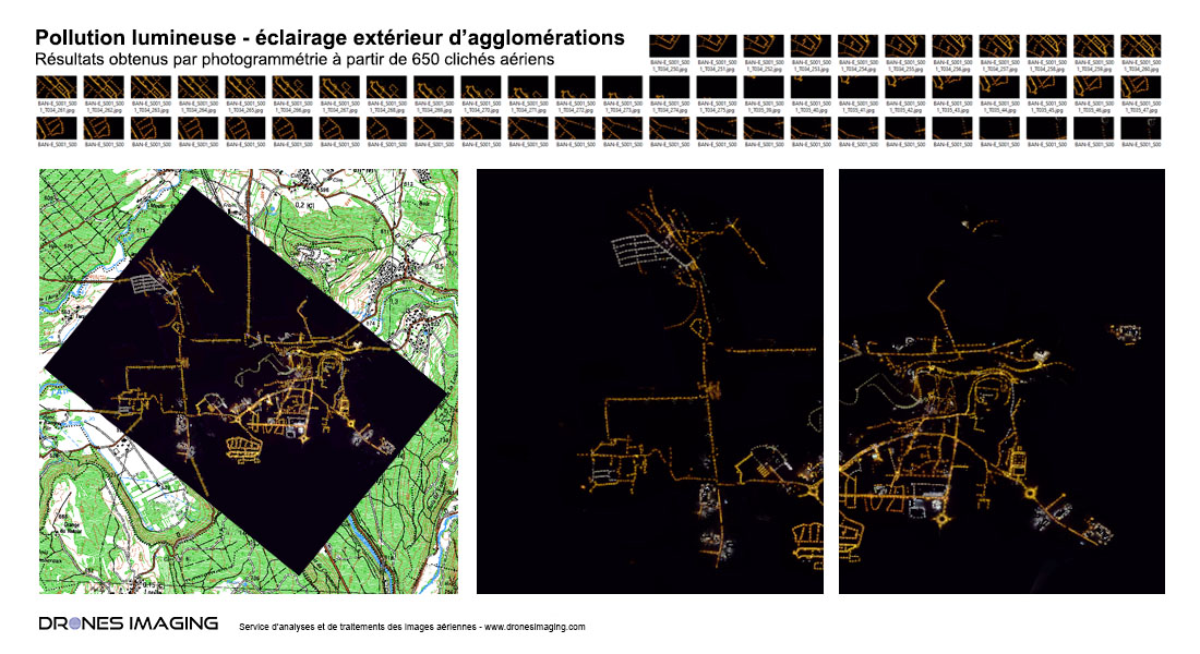
Above, the orthophoto with a 10cm resolution made from aerial and nocturnal visible images.

a very technical service intended to support local authorities in evaluating the performance of the lighting stock present on their territory, whether of public or private origin. This service delivering a global and high-resolution vision of inhabited areas also makes it possible to identify the origin of light pollution (glare, intrusive lights, over-illumination, etc.) but also to assess disturbances to nocturnal flora and fauna, health impact and energy waste.

TECHNICAL INFORMATIONS

  • Data processing service : Drones Imaging.
  • Spatial accuracy : metric.
  • Orthophoto RVB : GSD 10cm.
  • Covered area : 22km²
  • Photogrammetry software : Metashape
PrevPrécédentInspection of engineering works carried out by drone and aerial photogrammetry
SuivantTopographic map of a tourist complex in CorsicaNext
  • Mentions légales
  • Français
  • English