Skip to content
Services et traitements des images aériennes
Twitter Facebook Linkedin
  • Français
  • English
DRONES IMAGING
  • Drones imaging
    • Who are we
  • images processing service
    • topographic service
    • thermographic service
    • agricultural service
    • automatic counting service
    • Use case
    • Product sheets
    • useful documentation
    • download guide
  • Trainings
    • training in photogrammetry metashape option
    • training in photogrammetry Pix4D option
    • Multispectral training
    • online photogrammetry training
  • Softwares
    • Agisoft Metashape photogrammetry software
    • Undet software
  • RTK Receivers
    • EMLID GNSS RTK Reach RS3
    • EMLID GNSS RTK Reach RS2+
    • Emlid GNSS RTK Reach RX
    • EMLID GNSS RTK Reach RS+
  • Sensors
    • Agrowing Multispectral cameras
  • News
  • Contact us
  • Toggle website search
Menu Close
  • Drones imaging
    • Who are we
  • images processing service
    • topographic service
    • thermographic service
    • agricultural service
    • automatic counting service
    • Use case
    • Product sheets
    • useful documentation
    • download guide
  • Trainings
    • training in photogrammetry metashape option
    • training in photogrammetry Pix4D option
    • Multispectral training
    • online photogrammetry training
  • Softwares
    • Agisoft Metashape photogrammetry software
    • Undet software
  • RTK Receivers
    • EMLID GNSS RTK Reach RS3
    • EMLID GNSS RTK Reach RS2+
    • Emlid GNSS RTK Reach RX
    • EMLID GNSS RTK Reach RS+
  • Sensors
    • Agrowing Multispectral cameras
  • News
  • Contact us
  • Toggle website search

Blog

  1. Home>
  2. geomatics>
  3. Inspection of engineering works carried out by drone and aerial photogrammetry

Inspection of engineering works carried out by drone and aerial photogrammetry

  • March 11, 2022
  • 3:21 pm

Sub-millimeter orthofacades of the Arche de la Défense vertical walls

Results obtained from 2640 aerial images taken by the company UFLY Drones.

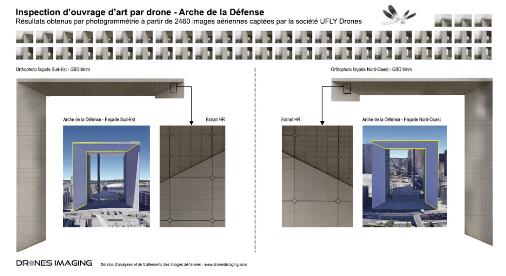
Above, the two orthofacades of a 6mm GSD each for the detailed inspection of the two sides.

Subsequently analyzed by a professional in building pathologies, orthophotos will make it possible to precisely locate some defects such as: slabs loosening, joint strips separations, cracks, infiltrations, rust traces and any other structural defects that can adversely affect the safety of the structure and its surroundings.

Orthophotos directly delivered to the design office in charge of the auscultation operations and safety reports project.

TECHNICAL INFORMATIONS

  • Aerial images source : UFLY Drones & Thomas Lafon.
  • Data processing service : Drones Imaging.
  • Spatial accuracy : centimeter.
  • Orthophoto RVB : 6mm GSD.
  • Inspected area : 6050m²
  • Photogrammetry software : Metashape
PrevPrécédentTopographic survey carried out by gyrocopter
SuivantStudy of light pollution for energy waste and enhancement of the nocturnal landscapeNext
  • Mentions légales
  • Français
  • English