Skip to content
Services et traitements des images aériennes
Twitter Facebook Linkedin
  • Français
  • English
DRONES IMAGING
  • Drones imaging
    • Who are we
  • images processing service
    • topographic service
    • thermographic service
    • agricultural service
    • automatic counting service
    • Use case
    • Product sheets
    • useful documentation
    • download guide
  • Trainings
    • training in photogrammetry metashape option
    • training in photogrammetry Pix4D option
    • Multispectral training
    • online photogrammetry training
  • Softwares
    • Agisoft Metashape photogrammetry software
    • Undet software
  • RTK Receivers
    • EMLID GNSS RTK Reach RS3
    • EMLID GNSS RTK Reach RS2+
    • Emlid GNSS RTK Reach RX
    • EMLID GNSS RTK Reach RS+
  • Sensors
    • Agrowing Multispectral cameras
  • News
  • Contact us
  • Toggle website search
Menu Close
  • Drones imaging
    • Who are we
  • images processing service
    • topographic service
    • thermographic service
    • agricultural service
    • automatic counting service
    • Use case
    • Product sheets
    • useful documentation
    • download guide
  • Trainings
    • training in photogrammetry metashape option
    • training in photogrammetry Pix4D option
    • Multispectral training
    • online photogrammetry training
  • Softwares
    • Agisoft Metashape photogrammetry software
    • Undet software
  • RTK Receivers
    • EMLID GNSS RTK Reach RS3
    • EMLID GNSS RTK Reach RS2+
    • Emlid GNSS RTK Reach RX
    • EMLID GNSS RTK Reach RS+
  • Sensors
    • Agrowing Multispectral cameras
  • News
  • Contact us
  • Toggle website search

Blog

  1. Home>
  2. geomatics>
  3. Technical inspection of a refinery performed by drone

Technical inspection of a refinery performed by drone

  • October 25, 2015
  • 3:08 am

Inspection of a cracking tower and detection of disorders

Inspection of a cracking tower: Photogrammetry views of the 4 sides of the chimney. Job done from 6500 aerial shots taken by the company Fovea Expertises, specialized in technical inspections by drones.

Orthophotos of the each face

Inspection of a cracking tower

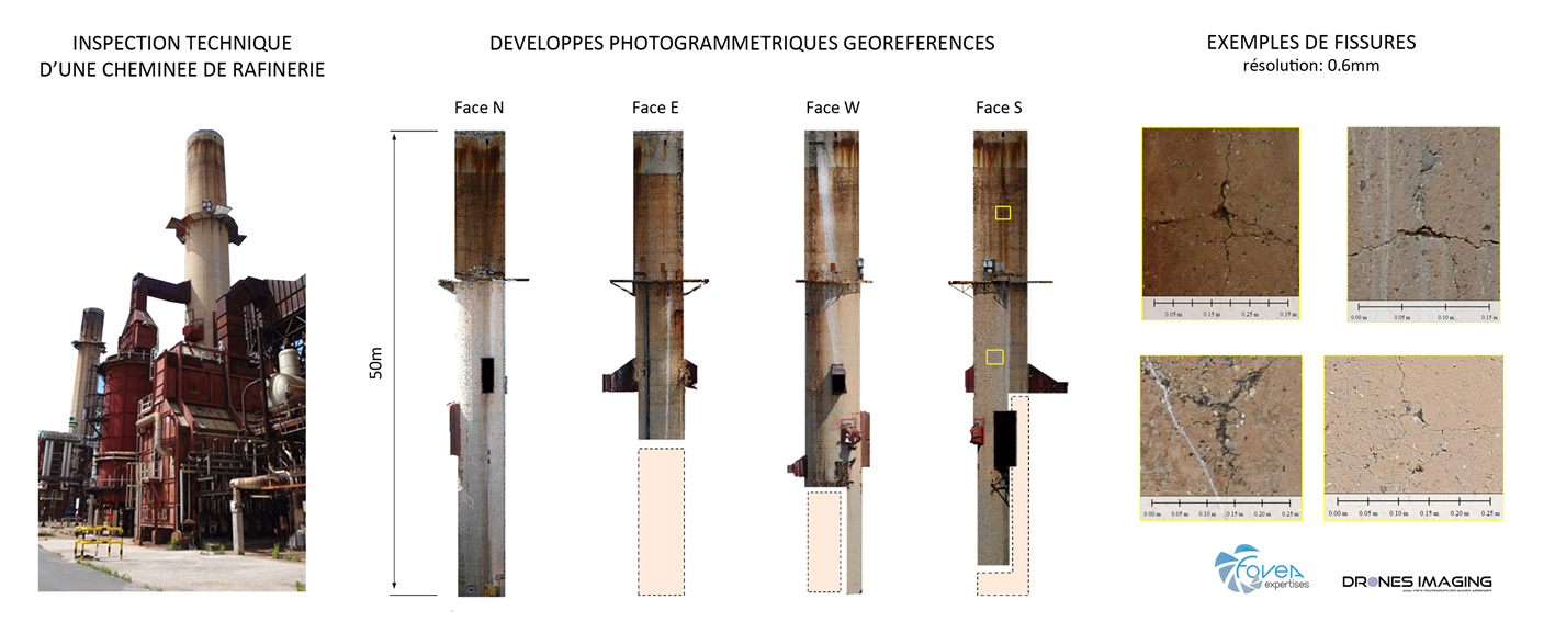
The flight automation programmed with the drone X6 Mikrokopter allowed to photograph the whole 360° cracking tower (with ultra high definition: pixel at 0.6 mm). The images acquired were then used to model the structure in 3 dimensions, allowing the export of 4 georeferenced orthofaces. These 4 orthophotos were sent directly on D+3 to the design office responsible for quantifying and locating the defects without the refinery having had to carry out a functional shutdown of the chimney or having resorted to risky human intervention on the superstructure .

Positive detections noted on the structure:

Cracks.
Bursts.

TECHNICAL INFORMATIONS

  • Post-processing service : Drones Imaging company.
  • Flights and aerial imagery : Fovéa Expertises company.
  • Spatial accuracy : relative centimeter.
  • Orthophoto RVB : GSD 0.6mm.
  • Drone : Mikrokopter X6.
  • Camera : Panasonic GH4.
  • Photogrammetry software : Metashape.
  • Export formats : GeoTiff and Obj.
  • Delivery Delays : 3 days.
PrevPrécédentEngineering structure inspection by drone
SuivantTopographic plans drawing service for mines and quarriesNext
  • Mentions légales
  • Français
  • English