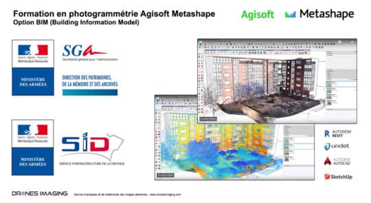
Ministry of the Armed Forces – Training course... geomatics August 12, 2020 photogrammetry training BIM option (Building Information Model) Photogrammetry training BIM option carried out in two parts using the Agisoft Continuer la lecture
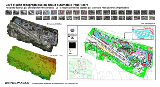
Le Castellet – Survey and topographic map of... geomatics March 12, 2020 Le Castellet – Survey and topographic map of the Paul Ricard racing circuit made by drone and aerial photogrammetry Continuer la lecture
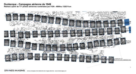
Historical orthophoto of the Dunkirk city in 1949 geomatics October 8, 2019 Historical orthophoto of the Dunkirk city in 1949 Historical orthophoto of Dunkirk built for the observation of the territory Continuer la lecture
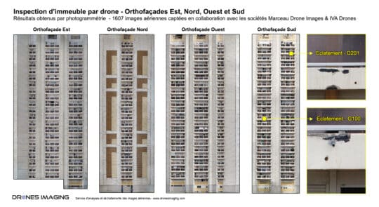
Facade inspection by drone and aerial photogrammetry geomatics September 17, 2019 Facade inspection by drone and aerial photogrammetry Facade inspection by drone: results obtained from 3500 aerial images as part Continuer la lecture
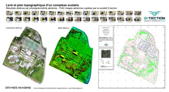
Autocad map of a school complex built by... geomatics July 25, 2019 Autocad map of a 10ha area built from orthophoto and classified Digital Surface Model. Autocad map, July 2019 – Continuer la lecture
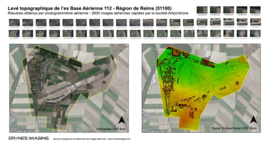
Long range photogrammetry by gyroplane – Topographic survey... geomatics March 19, 2019 Topographic survey of 1100 hectares carried out by aerial photogrammetry Aerial photogrammetry by gyroplane: results obtained from 2600 aerial Continuer la lecture
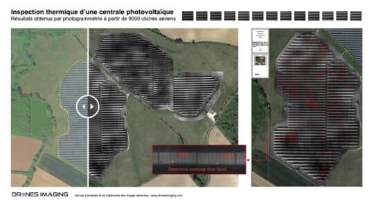
Thermal inspection of photovoltaic panels geomatics March 7, 2019 Thermal inspection of solar panels – Detection and localization of hotspot heating for yield losses evaluation. Thermal inspection: results Continuer la lecture
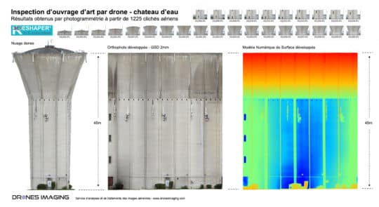
Water tower inspection by drone – surface analysis geomatics January 23, 2019 Water tower inspection by drone and aerial photogrammetry Water tower inspection: results obtained from 1225 aerial images taken by Continuer la lecture
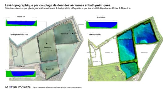
Topographic and bathymetric survey by drone in Corsica geomatics January 9, 2019 Bathymetry and aerial photogrammetry over a 55ha quarry Bathymetry and aerial photogrammetry: results obtained from 740 aerial images taken Continuer la lecture
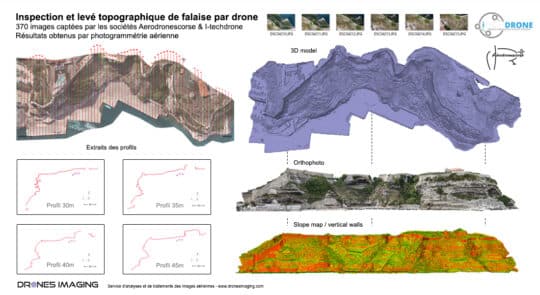
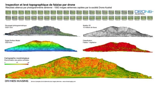
Cliff inspection by drone and photogrammetry geomatics September 24, 2018 Cliff inspection by drone and aerial photogrammetry in Bonifacio Cliff inspection, September 2018. Results obtained from 370 aerial images Continuer la lecture
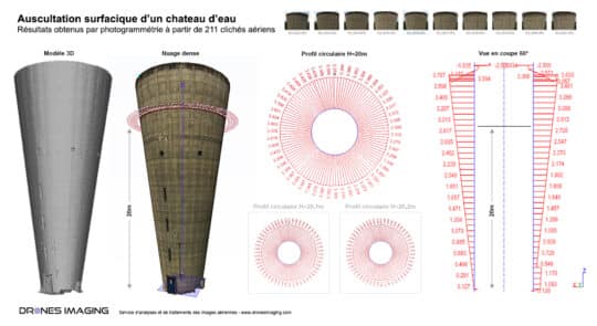
Inspection of structures by drone – circularity study... geomatics August 10, 2018 Engineering structure inspection: circularity study of a water tower by photogrammetry. Engineering structure inspection: results obtained from 211 aerial Continuer la lecture
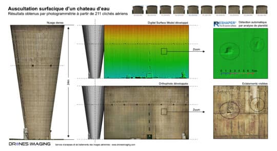
Auscultation of a water tower walls by drone... geomatics April 17, 2018 BIM inspection by drone and automatic detection of disorders BIM inspection by drone: results obtained from 211 aerial shots Continuer la lecture
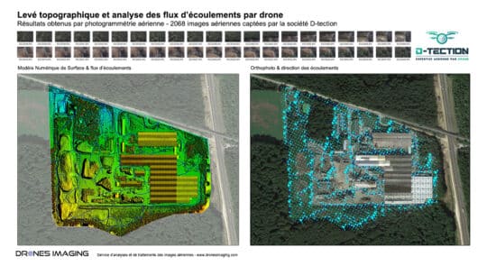
Technological risks study by drone – flow analysis... geomatics March 14, 2018 Technological risks study by drone – flow analysis and simulation of pollutants dispersion. Technological risks study by drone : Continuer la lecture
3D survey of the Cap Champagne cliff –... geomatics March 6, 2018 Cliff survey of the Cap Champagne carried out by drone and photogrammetry – Reunion Island Cliff survey carried out Continuer la lecture
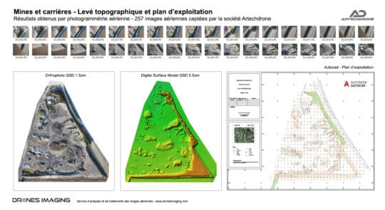
Topographic survey and annual mining map geomatics March 2, 2018 Annual mining map and stockpiles calculation made by drone and photogrammetry. Annual mining map and stockpiles inventory. Results obtained Continuer la lecture
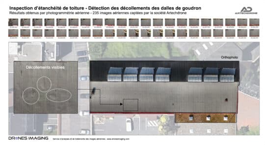
Roof inspection by drone and photogrammetry geomatics February 26, 2018 Roof inspection by drone. Roof inspection by drone: detection and localization of sealing plate peeling off. Results obtained from Continuer la lecture
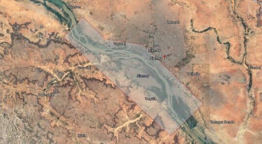
Flood forecasting: Topographic survey in Niamey to deal... geomatics January 19, 2018 Flood forecasting: Topographic survey in Niamey to deal with the rise of the Niger River Flood forecasting by aerial Continuer la lecture
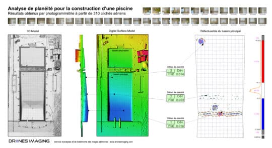
Flatness analysis of a swimming pool achieved by... geomatics December 29, 2017 Flatness analysis of a swimming pool by drone Flatness analysis: 3d modeling by photogrammetry for the inspection of a Continuer la lecture
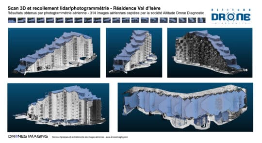
3D modeling of a tourist residence by coupling... geomatics November 15, 2017 Laser and photogrammetry data merge: 3D modeling of a tourist residence by coupling aerial and terrestrial points cloud Laser Continuer la lecture
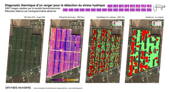
Water stress detection by drone and infrared thermography geomatics September 25, 2017 Water stress detection by drone and infrared thermography 2017 phenotyping campaign in Corsica – Water stress detection for irrigation Continuer la lecture