3D modeling by photogrammetry of the Pic du midi d'Ossau.
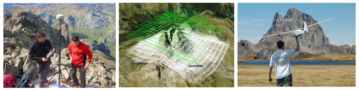
3D modeling by photogrammetry of the Pic du midi d’Ossau, a 2884m altitude massif in the French Pyrenees. On the occasion of the 70th anniversary of the UNGE, 3 companies in the drone sector have closely collaborated for the benefit of the UNGE (National Union of Surveyors-Experts) to model and map the Pic du Midi d’Ossau with a resolution varying from 5cm to 10cm.
3D animated
Co-manager of the firm AirCity Diagnostic and civil drone operator in Aquitaine, in the south west of France, Loïc Richard was the project manager in charge of coordinating the operations and setting up the technological partnerships required for the success of the project.
« In order to map and model the Pic d’Ossau over such a wide area (about 400 ha), we naturally opted for the Parisian firm Aeromapper which engineers and exploits long endurance, long range drones (out of sight flying mode in accordance with the French S4 scenario legislation) This type of material can carry a 24 million pixel DSLR camera equipped with a high quality 19 mm focal lens which guarantees a unique accuracy and quality of image on the market. »
After the feasibility study and the acceptation of the project by Aeromapper, we could work alongside with Drones Imaging, a firm specialized in photogrammetry and in charge of post processing the data during this project.
« Through this collaborative work, we could master the value chain of a complex mission during which everyone provided their own assessments, ie flight-plan designing according to photogrammetric standards, high altitude flying or post-processing » Loïc Richard explained.
Teaser
« One month before the mission started, a fiddly study of the Pic du midi d’Ossau allowed us to spot the various problematic areas of the peak. For instance, vertical shootings were completed with oblique ones to map rocky overhangs and thus cover the entire Ossau peak. Also the flight sampling strategy according to the sun brightness allowed us to reduce the shadow factor to have the best quality pictures » Loïc Hussenet, Drones Imaging CEO said.
October 2015, 17, after a 2 hour walk supporting a full back-pack drone equipment, the teams started taking the first aerial pictures at the foot of the peak. Ground targets had been dispatched in advance by land surveyors all around the peak.
From then on, after climbing 900 meters, Aeromapper’s AVEM started its automatic flight plan and recorded more than 1,500 pictures, at a 3,000 meters altitude. This extreme conditions flight was easily carried out thanks to this high-tech cartographic device and led to the complete Ossau peak 3D modeling.
A second operation is planned in 2016 to enhance measurements and flight plans but the first results are already promising thanks to the association of the land surveying and drone operating industries.
TECHNICAL INFORMATIONS
- Aerial imagery post-processing service : Drones Imaging company.
- Aerial capture : Aeromapper company.
- Spatial accuracy : centimeter.
- Orthophoto RVB : GSD 5/10cm.
- Covered area : 400ha.
- Drone : AVEM.
- Photogrammetry software : Metashape.
- Delivery delay : 3 days.
- Use case taught during our photogrammetry training : see more.