Skip to content
Services et traitements des images aériennes
Twitter Facebook Linkedin
  • Français
  • English
DRONES IMAGING
  • Drones imaging
    • Who are we
  • images processing service
    • topographic service
    • thermographic service
    • agricultural service
    • automatic counting service
    • Use case
    • Product sheets
    • useful documentation
    • download guide
  • Trainings
    • training in photogrammetry metashape option
    • training in photogrammetry Pix4D option
    • Multispectral training
    • online photogrammetry training
  • Softwares
    • Agisoft Metashape photogrammetry software
    • Undet software
  • RTK Receivers
    • EMLID GNSS RTK Reach RS3
    • EMLID GNSS RTK Reach RS2+
    • Emlid GNSS RTK Reach RX
    • EMLID GNSS RTK Reach RS+
  • Sensors
    • Agrowing Multispectral cameras
  • News
  • Contact us
  • Toggle website search
Menu Close
  • Drones imaging
    • Who are we
  • images processing service
    • topographic service
    • thermographic service
    • agricultural service
    • automatic counting service
    • Use case
    • Product sheets
    • useful documentation
    • download guide
  • Trainings
    • training in photogrammetry metashape option
    • training in photogrammetry Pix4D option
    • Multispectral training
    • online photogrammetry training
  • Softwares
    • Agisoft Metashape photogrammetry software
    • Undet software
  • RTK Receivers
    • EMLID GNSS RTK Reach RS3
    • EMLID GNSS RTK Reach RS2+
    • Emlid GNSS RTK Reach RX
    • EMLID GNSS RTK Reach RS+
  • Sensors
    • Agrowing Multispectral cameras
  • News
  • Contact us
  • Toggle website search

Blog

  1. Home>
  2. geomatics>
  3. Energy diagnosis of the urban community of Meaux

Energy diagnosis of the urban community of Meaux

  • March 22, 2023
  • 7:48 am

Aerial thermography by plane for the energy diagnosis of the urban community of Meaux

Aerial thermography by plane: results obtained from 18,790 infrared shots taken by the company Les 4 Vents. Post-processing and imagery analysis by Drones Imaging.

Aerial thermography by plane is a diagnostic method that allows mapping of temperature variations on a large metropolitan scale. Increasingly used in France, this technology enables the evaluation of building energy efficiency and the improvement of territorial planning.

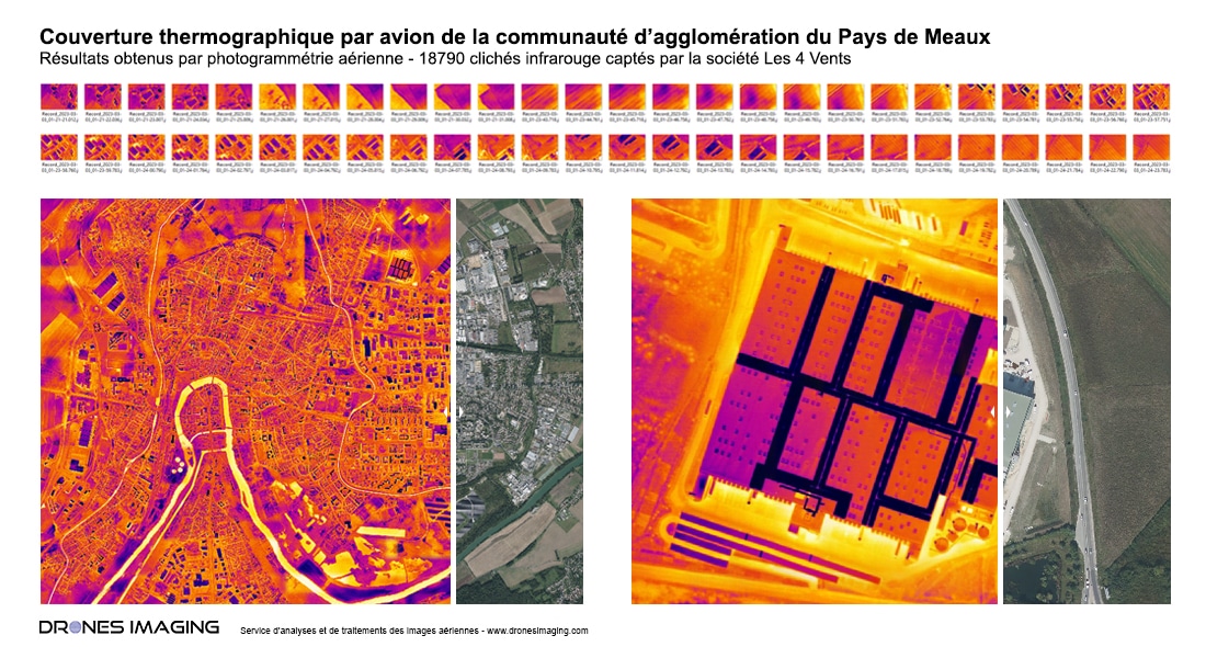
The principle of aerial thermography involves using an infrared sensor onboard a plane to measure the thermal radiation emitted by buildings and urban surfaces in each image. The set of images, whose overlaps meet photogrammetry standards, enables the building of a detailed and georeferenced thermal orthophoto of the city, on which each infrastructure is perfectly locatable. Example below:

Thermal orthophoto of the urban community of Meaux

Aerial thermography by plane

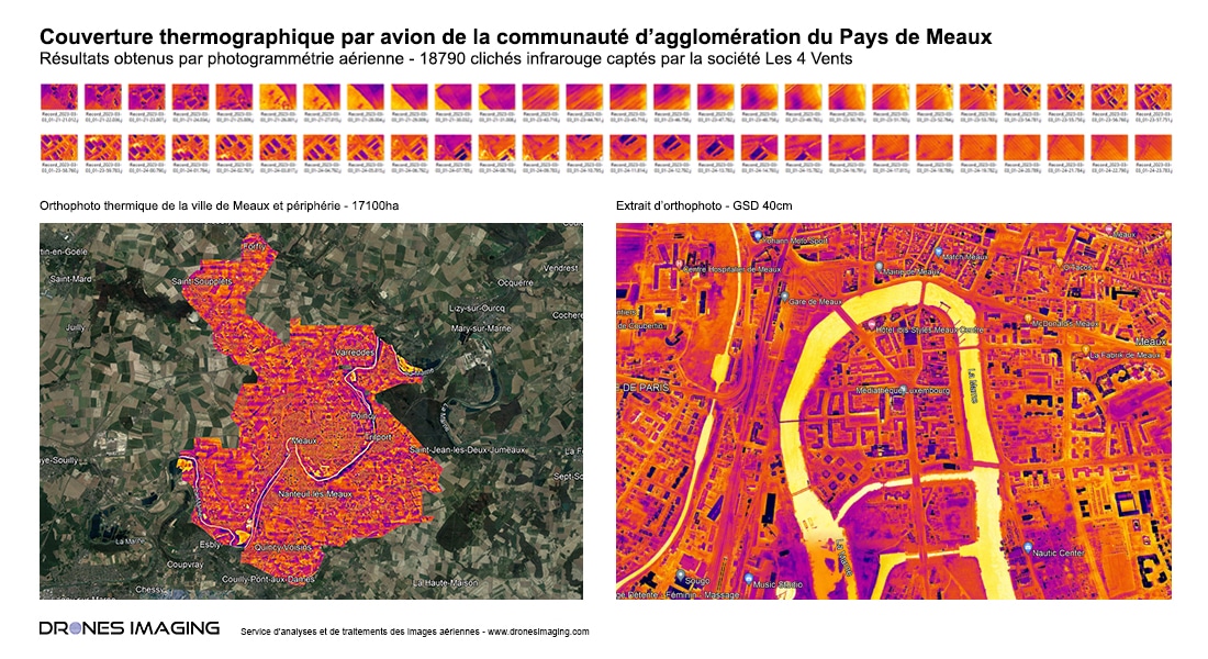
Once generated, the thermal orthophoto constitutes the ideal working support to locate leaks or overheating areas. It allows for easy detection of defects in urban equipment, evaluation of building energy efficiency, and more generally, mapping urban areas with high or low temperatures. Today, this technology is a valuable tool for property owners, infrastructure managers, or urban planners to make informed decisions about improving building energy efficiency or future urban planning.

Orthophoto and high resolution extract for the thermal diagnosis

Aerial thermography by plane

TECHNICAL INFORMATIONS

  • Infrared thermal image processing service : Drones Imaging company.
  • Flights and aerial capture : Les 4 Vents company.
  • Spatial accuracy : metric.
  • Dataset : 18790 images.
  • Orthophoto RVB : GSD 40cm.
  • Covered area : 17100ha.
  • Airborne platform : avion PIPER PA34.
  • Infrared sensor resolution : 640×480.
  • Photogrammetry software : Metashape.
  • Geographic information system : ArcGis.
  • Use case taught during our photogrammetry training : See more.

PrevPrécédentVisual inspection and safety study of a dam carried out by drone
SuivantAutomated counting of grapevine plants for the detection of missing onesNext
  • Mentions légales
  • Français
  • English