Skip to content
Services et traitements des images aériennes
Twitter Facebook Linkedin
  • Français
  • English
DRONES IMAGING
  • Drones imaging
    • Who are we
  • images processing service
    • topographic service
    • thermographic service
    • agricultural service
    • automatic counting service
    • Use case
    • Product sheets
    • useful documentation
    • download guide
  • Trainings
    • training in photogrammetry metashape option
    • training in photogrammetry Pix4D option
    • Multispectral training
    • online photogrammetry training
  • Softwares
    • Agisoft Metashape photogrammetry software
    • Undet software
  • RTK Receivers
    • EMLID GNSS RTK Reach RS3
    • EMLID GNSS RTK Reach RS2+
    • Emlid GNSS RTK Reach RX
    • EMLID GNSS RTK Reach RS+
  • Sensors
    • Agrowing Multispectral cameras
  • News
  • Contact us
  • Toggle website search
Menu Close
  • Drones imaging
    • Who are we
  • images processing service
    • topographic service
    • thermographic service
    • agricultural service
    • automatic counting service
    • Use case
    • Product sheets
    • useful documentation
    • download guide
  • Trainings
    • training in photogrammetry metashape option
    • training in photogrammetry Pix4D option
    • Multispectral training
    • online photogrammetry training
  • Softwares
    • Agisoft Metashape photogrammetry software
    • Undet software
  • RTK Receivers
    • EMLID GNSS RTK Reach RS3
    • EMLID GNSS RTK Reach RS2+
    • Emlid GNSS RTK Reach RX
    • EMLID GNSS RTK Reach RS+
  • Sensors
    • Agrowing Multispectral cameras
  • News
  • Contact us
  • Toggle website search

Blog

  1. Home>
  2. geomatics>
  3. 3D modeling by terrestrial photographic capture

3D modeling by terrestrial photographic capture

  • October 12, 2016
  • 10:40 am

Terrestrial photogrammetry applied to BIM

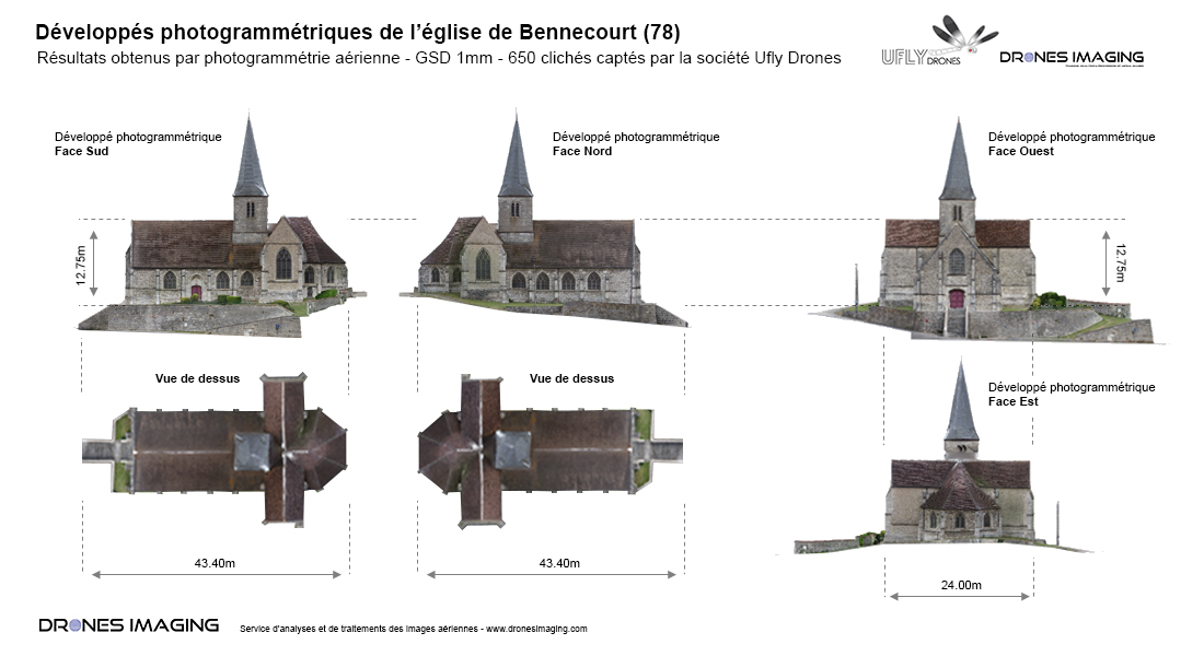
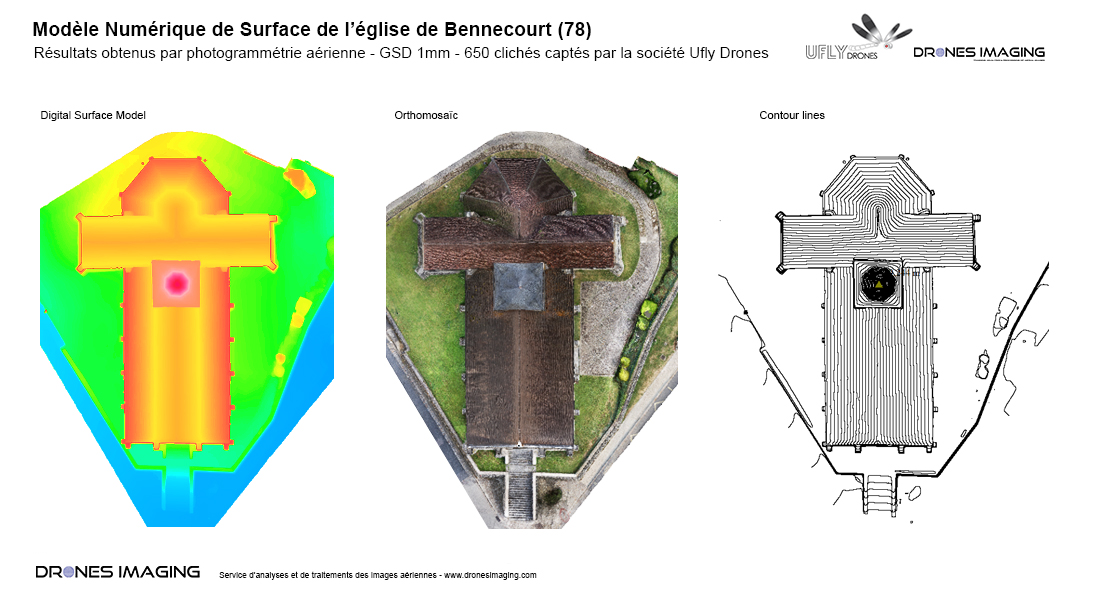
Terrestrial photogrammetry and digital twin of the church of Bennecourt. Topographic survey, October 2016: results obtained from 650 terrestrial images taken by Ufly Drones, post-processed by Drones Imaging.

Orthophotos of the roof and the four facades of the church

Terrestrial photogrammetry

BIM model 3D visualization

Topographic survey carried out without drone, by photogrammetry from land shots. This 3D restitution technique is currently the most efficient and economical solution for carrying out precision surveys with complex facades.

TECHNICAL INFORMATIONS

  • Aerial imagery processing service : Drones Imaging company.
  • Terresrial imagery : UFLY Drone company.
  • Spatial accuracy : centimeter.
  • Orthophoto RVB : GSD 1mm.
  • Inspected areas : 4 facades + 1 roof.
  • Camera : SONY RX100.
  • Photogrammetry software : Metashape.
  • Delivery time upon receipt of images : 24h00.
  • Use case taught during our Agisoft Metashape training : see more.
PrevPrécédentPhotogrammetry & multi-color 3D printing of the Pic du midi d’Ossau
SuivantPhotogrammetry applied to thermal imaging and solar panel inspectionsNext
  • Mentions légales
  • Français
  • English