Skip to content
Services et traitements des images aériennes
Twitter Facebook Linkedin
  • Français
  • English
DRONES IMAGING
  • Drones imaging
    • Who are we
  • images processing service
    • topographic service
    • thermographic service
    • agricultural service
    • automatic counting service
    • Use case
    • Product sheets
    • useful documentation
    • download guide
  • Trainings
    • training in photogrammetry metashape option
    • training in photogrammetry Pix4D option
    • Multispectral training
    • online photogrammetry training
  • Softwares
    • Agisoft Metashape photogrammetry software
    • Undet software
  • RTK Receivers
    • EMLID GNSS RTK Reach RS3
    • EMLID GNSS RTK Reach RS2+
    • Emlid GNSS RTK Reach RX
    • EMLID GNSS RTK Reach RS+
  • Sensors
    • Agrowing Multispectral cameras
  • News
  • Contact us
  • Toggle website search
Menu Close
  • Drones imaging
    • Who are we
  • images processing service
    • topographic service
    • thermographic service
    • agricultural service
    • automatic counting service
    • Use case
    • Product sheets
    • useful documentation
    • download guide
  • Trainings
    • training in photogrammetry metashape option
    • training in photogrammetry Pix4D option
    • Multispectral training
    • online photogrammetry training
  • Softwares
    • Agisoft Metashape photogrammetry software
    • Undet software
  • RTK Receivers
    • EMLID GNSS RTK Reach RS3
    • EMLID GNSS RTK Reach RS2+
    • Emlid GNSS RTK Reach RX
    • EMLID GNSS RTK Reach RS+
  • Sensors
    • Agrowing Multispectral cameras
  • News
  • Contact us
  • Toggle website search

Blog

  1. Home>
  2. geomatics>
  3. Drone roof inspections – Avoriaz

Drone roof inspections – Avoriaz

  • November 17, 2016
  • 3:10 pm

Roof diagnosis by drone

Roof diagnosis by drone, 3D modeling and mapping of 4 roofs on the Avoriaz ski resort. Results obtained from 3400 aerial shots taken by the Qualiconsult group. Post-processing service by Drones Imaging.

3D modeling and orthophotos for the control and maintenance of roofs

Roof diagnosis by drone

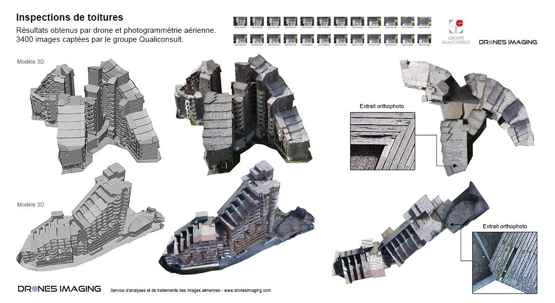
Above, the orthophotos and 3D models generated made it possible to detect and quantify precisely the repairs to be undertaken but also the various maintenance works to be started before the opening of the ski resort.

TECHNICAL INFORMATIONS

  • Aerial imagery post ptocessing service : Drones Imaging company.
  • Flights and aerial images : Qualiconsult group.
  • Spatial accuracy : centimeter.
  • Orthophoto RVB : GSD 5mm.
  • Drone : Mikrokopter.
  • Camera :  Sony A6000.
  • Covered area : 4800m² in total for the 4 inspected roofs.
  • Photogrammetry software : Agisoft Metashape.
  • Export formats : GeoTiff and Obj.
  • Delivery times upon receipt of images : 2 days.
  • Use case taught in training : see more.
PrevPrécédentPhotogrammetry applied to thermal imaging and solar panel inspections
SuivantGame damage diagnosis carried out by droneNext
  • Mentions légales
  • Français
  • English