Skip to content
Services et traitements des images aériennes
Twitter Facebook Linkedin
  • Français
  • English
DRONES IMAGING
  • Drones imaging
    • Who are we
  • images processing service
    • topographic service
    • thermographic service
    • agricultural service
    • automatic counting service
    • Use case
    • Product sheets
    • useful documentation
    • download guide
  • Trainings
    • training in photogrammetry metashape option
    • training in photogrammetry Pix4D option
    • Multispectral training
    • online photogrammetry training
  • Softwares
    • Agisoft Metashape photogrammetry software
    • Undet software
  • RTK Receivers
    • EMLID GNSS RTK Reach RS3
    • EMLID GNSS RTK Reach RS2+
    • Emlid GNSS RTK Reach RX
    • EMLID GNSS RTK Reach RS+
  • Sensors
    • Agrowing Multispectral cameras
  • News
  • Contact us
  • Toggle website search
Menu Close
  • Drones imaging
    • Who are we
  • images processing service
    • topographic service
    • thermographic service
    • agricultural service
    • automatic counting service
    • Use case
    • Product sheets
    • useful documentation
    • download guide
  • Trainings
    • training in photogrammetry metashape option
    • training in photogrammetry Pix4D option
    • Multispectral training
    • online photogrammetry training
  • Softwares
    • Agisoft Metashape photogrammetry software
    • Undet software
  • RTK Receivers
    • EMLID GNSS RTK Reach RS3
    • EMLID GNSS RTK Reach RS2+
    • Emlid GNSS RTK Reach RX
    • EMLID GNSS RTK Reach RS+
  • Sensors
    • Agrowing Multispectral cameras
  • News
  • Contact us
  • Toggle website search

Blog

  1. Home>
  2. Non classé>
  3. Volume calculation of cuttings and embankments for a quarry rehabilitation

Volume calculation of cuttings and embankments for a quarry rehabilitation

  • March 27, 2017
  • 10:45 am

Cut and fill calculations for an extraction site rehabilitation

Cut and fill calculations for depollution and restoration of the Guignicourt quarry. Results obtained from 5763 aerial images taken by the company Artech’Drone.
Analysis and post-processing service for mining industry by Drones Imaging.

Orthophoto, Digital surface model and Autocad map

Cut and fill calculations

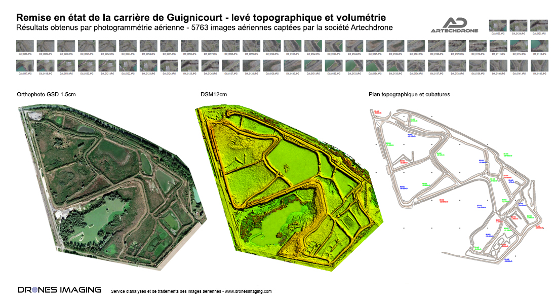
Artech’drone and Drones Imaging recently carried out, in the Marne (department 51), one topographic survey project on a 100ha disused quarry. Topographic survey carried out by aerial photogrammetry and necessary to calculate volumes of cuttings and embankments to be considered for the restoration of the site (cuttings depollution and terrain leveling).

The team in the field included two remote pilots, a surveyor and all the managers responsible for bringing the site back into compliance.

The project took place over one day using two multirotor drones to capture aerial images at a 50m height, thus obtaining a ground sample distance of 1cm. From the images collected, a 3D Digital Surface Model (DSM) was built by photogrammetry and from which: 4 million m3 of accumulated materials (to be backfilled and cleared) were calculated. These results allow managers to precisely quantify the extent of depollution work and to immediately commit the appropriate resources.

From a technical and economic point of view, this successful operation demonstrates the technical added value of the drone and image processing on large-scale missions.

TECHNICAL INFORMATIONS

  • Image analysis and processing service : Drones Imaging company.
  • Flights and imagery capture : Artech’Drone company.
  • Spatial accuracy : centimeter.
  • Orthophoto RVB : GSD 1.5cm
  • Total covered area : 100ha.
  • Drone : Phantom 4.
  • Sensor : FC6310.
  • Photogrammetry software : Agisoft Metashape.
  • Use case taught during photogrammetry training : see more.
PrevPrécédentTopographic survey of the dykes at the Bastia port.
Suivant3D thermal mapping by photogrammetryNext
  • Mentions légales
  • Français
  • English