Skip to content
Services et traitements des images aériennes
Twitter Facebook Linkedin
  • Français
  • English
DRONES IMAGING
  • Drones imaging
    • Who are we
  • images processing service
    • topographic service
    • thermographic service
    • agricultural service
    • automatic counting service
    • Use case
    • Product sheets
    • useful documentation
    • download guide
  • Trainings
    • training in photogrammetry metashape option
    • training in photogrammetry Pix4D option
    • Multispectral training
    • online photogrammetry training
  • Softwares
    • Agisoft Metashape photogrammetry software
    • Undet software
  • RTK Receivers
    • EMLID GNSS RTK Reach RS3
    • EMLID GNSS RTK Reach RS2+
    • Emlid GNSS RTK Reach RX
    • EMLID GNSS RTK Reach RS+
  • Sensors
    • Agrowing Multispectral cameras
  • News
  • Contact us
  • Toggle website search
Menu Close
  • Drones imaging
    • Who are we
  • images processing service
    • topographic service
    • thermographic service
    • agricultural service
    • automatic counting service
    • Use case
    • Product sheets
    • useful documentation
    • download guide
  • Trainings
    • training in photogrammetry metashape option
    • training in photogrammetry Pix4D option
    • Multispectral training
    • online photogrammetry training
  • Softwares
    • Agisoft Metashape photogrammetry software
    • Undet software
  • RTK Receivers
    • EMLID GNSS RTK Reach RS3
    • EMLID GNSS RTK Reach RS2+
    • Emlid GNSS RTK Reach RX
    • EMLID GNSS RTK Reach RS+
  • Sensors
    • Agrowing Multispectral cameras
  • News
  • Contact us
  • Toggle website search

Blog

  1. Home>
  2. geomatics>
  3. Water stress detection by drone and infrared thermography

Water stress detection by drone and infrared thermography

  • September 25, 2017
  • 12:57 pm

Water stress detection by drone and infrared thermography

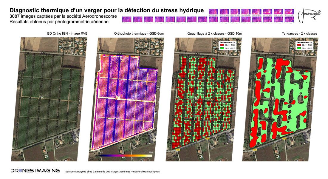
2017 phenotyping campaign in Corsica – Water stress detection for irrigation management in a citrus plantation (pomelos). Results obtained from 3087 thermal images taken by the company I-Techdrone. Analysis and data processing service by Drones Imaging.

Thermal orthophoto and water stress zonal classifications

Water stress detection

With high sensitive plants such as citrus, water deficit is a phenomenon that directly affects physiological variables. It results in a sharp decline of crop quality and yield.

If automatic irrigation is the first response to climate change and soil aridity, plantation irrigation methods and strategies have become an economic issue for farmers. In this context, the local Corsican agricultural community, in partnership with I-Techdrone and Drones Imaging companies, tested new technologies for the management of irrigation allowing inputs rationalization according to the needs of the crop.

Indeed, thanks to a thermal orthophography carried out above a 17ha orchard, the temperature measurements on the whole plot allowed to evaluate the water potential of the vegetal cover. They have proved very useful to identify areas requiring more or less water. If this initial diagnosis already allows the operator to pilot its irrigation, other plantation overflights are already programmed at key stages for annual monitoring and accurate irrigation over time.

INFORMATIONS TECHNIQUES

  • Analysis and data processing service : Drones Imaging company.
  • Flights and thermal imagery : I-Techdrone company.
  • Spatial accuracy : metric with IGN BD Ortho.
  • Covered area : 17.5ha.
  • Drone : Mikrokopter.
  • Thermal sensor : Optris PI 450.
  • Photogrammetry software : Agisoft Metashape.
  • Geographic Information System : Arcgis.
  • Export formats : GéoTiff, Shp and Kmz.
  • Delivery delays : 3 days upon receipt images.
PrevPrécédentFlood simulation for DREAL
Suivant3D modeling of a tourist residence by coupling laser and photogrammetric dataNext
  • Mentions légales
  • Français
  • English