Skip to content
Services et traitements des images aériennes
Twitter Facebook Linkedin
  • Français
  • English
DRONES IMAGING
  • Drones imaging
    • Who are we
  • images processing service
    • topographic service
    • thermographic service
    • agricultural service
    • automatic counting service
    • Use case
    • Product sheets
    • useful documentation
    • download guide
  • Trainings
    • training in photogrammetry metashape option
    • training in photogrammetry Pix4D option
    • Multispectral training
    • online photogrammetry training
  • Softwares
    • Agisoft Metashape photogrammetry software
    • Undet software
  • RTK Receivers
    • EMLID GNSS RTK Reach RS3
    • EMLID GNSS RTK Reach RS2+
    • Emlid GNSS RTK Reach RX
    • EMLID GNSS RTK Reach RS+
  • Sensors
    • Agrowing Multispectral cameras
  • News
  • Contact us
  • Toggle website search
Menu Close
  • Drones imaging
    • Who are we
  • images processing service
    • topographic service
    • thermographic service
    • agricultural service
    • automatic counting service
    • Use case
    • Product sheets
    • useful documentation
    • download guide
  • Trainings
    • training in photogrammetry metashape option
    • training in photogrammetry Pix4D option
    • Multispectral training
    • online photogrammetry training
  • Softwares
    • Agisoft Metashape photogrammetry software
    • Undet software
  • RTK Receivers
    • EMLID GNSS RTK Reach RS3
    • EMLID GNSS RTK Reach RS2+
    • Emlid GNSS RTK Reach RX
    • EMLID GNSS RTK Reach RS+
  • Sensors
    • Agrowing Multispectral cameras
  • News
  • Contact us
  • Toggle website search

Blog

  1. Home>
  2. geomatics>
  3. Topographic survey and annual mining map

Topographic survey and annual mining map

  • March 2, 2018
  • 1:59 pm

Annual mining map and stockpiles calculation made by drone and photogrammetry.

Annual mining map and stockpiles inventory. Results obtained from 257 aerial shots taken by the company Artech’Drone. Image processing service by Drones Imaging.

Topographic survey and mining map

annual mining map

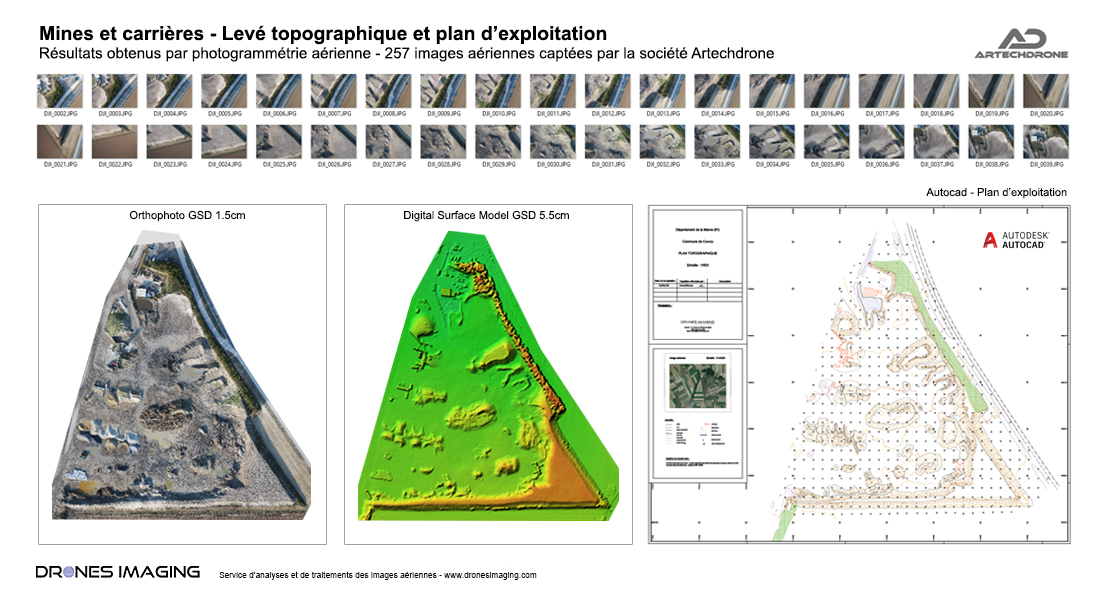
Topographical survey of the Courcy quarry (51). The orthophoto and the digital surface model built by photogrammetry made it possible to establish mining and volumetry map in Autocad format and according to the standards of the mining industry with spatial accuracy less than 3cm (planimetry and altimetry ).

TECHNICAL INFORMATIONS

  • Image processing service for mining industry : Drones Imaging company.
  • Flights and aerial imagery : Artech’Drone company.
  • Spatial accuracy : centimeter.
  • Orthophoto RVB : GSD 1cm.
  • Drone : DJI Inspire.
  • Sensor :  FC6520.
  • Covered area : 06ha.
  • Photogrammetry software : Metashape.
  • Export formats : GeoTiff, Dwg and Pdf.
  • Delivery delays : day+2
PrevPrécédentRoof inspection by drone and photogrammetry
Suivant3D survey of the Cap Champagne cliff – Reunion IslandNext
  • Mentions légales
  • Français
  • English