Skip to content
Services et traitements des images aériennes
Twitter Facebook Linkedin
  • Français
  • English
DRONES IMAGING
  • Drones imaging
    • Who are we
  • images processing service
    • topographic service
    • thermographic service
    • agricultural service
    • automatic counting service
    • Use case
    • Product sheets
    • useful documentation
    • download guide
  • Trainings
    • training in photogrammetry metashape option
    • training in photogrammetry Pix4D option
    • Multispectral training
    • online photogrammetry training
  • Softwares
    • Agisoft Metashape photogrammetry software
    • Undet software
  • RTK Receivers
    • EMLID GNSS RTK Reach RS3
    • EMLID GNSS RTK Reach RS2+
    • Emlid GNSS RTK Reach RX
    • EMLID GNSS RTK Reach RS+
  • Sensors
    • Agrowing Multispectral cameras
  • News
  • Contact us
  • Toggle website search
Menu Close
  • Drones imaging
    • Who are we
  • images processing service
    • topographic service
    • thermographic service
    • agricultural service
    • automatic counting service
    • Use case
    • Product sheets
    • useful documentation
    • download guide
  • Trainings
    • training in photogrammetry metashape option
    • training in photogrammetry Pix4D option
    • Multispectral training
    • online photogrammetry training
  • Softwares
    • Agisoft Metashape photogrammetry software
    • Undet software
  • RTK Receivers
    • EMLID GNSS RTK Reach RS3
    • EMLID GNSS RTK Reach RS2+
    • Emlid GNSS RTK Reach RX
    • EMLID GNSS RTK Reach RS+
  • Sensors
    • Agrowing Multispectral cameras
  • News
  • Contact us
  • Toggle website search

Blog

  1. Home>
  2. geomatics>
  3. Cliff inspection by drone and photogrammetry

Cliff inspection by drone and photogrammetry

  • September 24, 2018
  • 11:59 am

Cliff inspection by drone and aerial photogrammetry in Bonifacio

Cliff inspection, September 2018. Results obtained from 370 aerial images taken by the company I-techdrone as part of the restructuring of Bonifacio’s port infrastructure.

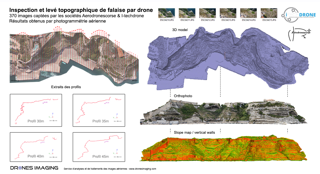
Orthophoto and three-dimensional cliff modeling

Inspection de falaise

3D Visualization

As part of the redevelopment of its port infrastructure, the Territorial Collective of Corsica (CTC) engaged the services of the companies I-techdrone and Drones Imaging for the topographic survey of a cliff measuring 400m length and 50m height in Bonifacio.

Using Metashape software, the 370 aerial shots taken by drone allowed to model the cliff in the form of a dense cloud (1pt every 5cm for a high accuracy and restitution of the site’s topography). The 3D model thus generated, whose spatial accuracy is a few centimeters (accuracy obtained thanks to targets previously arranged and measured with a GNSS RTK receiver) allowed the automated export of a hundred topographic sections (cross profiles over the entire length of the cliff) for the detection and location of overhanging areas (immediately identified as risk areas).

Subsequently, this 3D modeling will also serve as initial support to study the morphology of the rock walls and their evolution over time. Indeed, thanks to future aerial surveys and by temporal comparison, it will be possible to locate and quantify automatically the rock walls weakened by erosion and therefore potentially dangerous during the development work of the port.

TECHNICAL INFORMATIONS

  • Aerial images processing and analysis service : Drones Imaging.
  • Flights and aerial images : I-Techdrone company.
  • Spatial accuracy : centimeter.
  • Orthophoto RVB : GSD 4mm.
  • Total inspected area : 2ha.
  • Drone : MikroKopter.
  • Photogrammetry software : Agisoft Metashape.
  • Export formats : GéoTiff and Las.
  • Delivery delay : 2 days.
PrevPrécédentInspection of structures by drone – circularity study of a water tower
SuivantTopographic and bathymetric survey by drone in CorsicaNext
  • Mentions légales
  • Français
  • English