Skip to content
Services et traitements des images aériennes
Twitter Facebook Linkedin
  • Français
  • English
DRONES IMAGING
  • Drones imaging
    • Who are we
  • images processing service
    • topographic service
    • thermographic service
    • agricultural service
    • automatic counting service
    • Use case
    • Product sheets
    • useful documentation
    • download guide
  • Trainings
    • training in photogrammetry metashape option
    • training in photogrammetry Pix4D option
    • Multispectral training
    • online photogrammetry training
  • Softwares
    • Agisoft Metashape photogrammetry software
    • Undet software
  • RTK Receivers
    • EMLID GNSS RTK Reach RS3
    • EMLID GNSS RTK Reach RS2+
    • Emlid GNSS RTK Reach RX
    • EMLID GNSS RTK Reach RS+
  • Sensors
    • Agrowing Multispectral cameras
  • News
  • Contact us
  • Toggle website search
Menu Close
  • Drones imaging
    • Who are we
  • images processing service
    • topographic service
    • thermographic service
    • agricultural service
    • automatic counting service
    • Use case
    • Product sheets
    • useful documentation
    • download guide
  • Trainings
    • training in photogrammetry metashape option
    • training in photogrammetry Pix4D option
    • Multispectral training
    • online photogrammetry training
  • Softwares
    • Agisoft Metashape photogrammetry software
    • Undet software
  • RTK Receivers
    • EMLID GNSS RTK Reach RS3
    • EMLID GNSS RTK Reach RS2+
    • Emlid GNSS RTK Reach RX
    • EMLID GNSS RTK Reach RS+
  • Sensors
    • Agrowing Multispectral cameras
  • News
  • Contact us
  • Toggle website search

Blog

  1. Home>
  2. geomatics>
  3. Machine learning – automatic counting and spatial distribution of olive trees in a 13ha orchard in Andalusia.

Machine learning – automatic counting and spatial distribution of olive trees in a 13ha orchard in Andalusia.

  • March 30, 2021
  • 2:01 pm

Automatic objects detection & extraction by machine learning

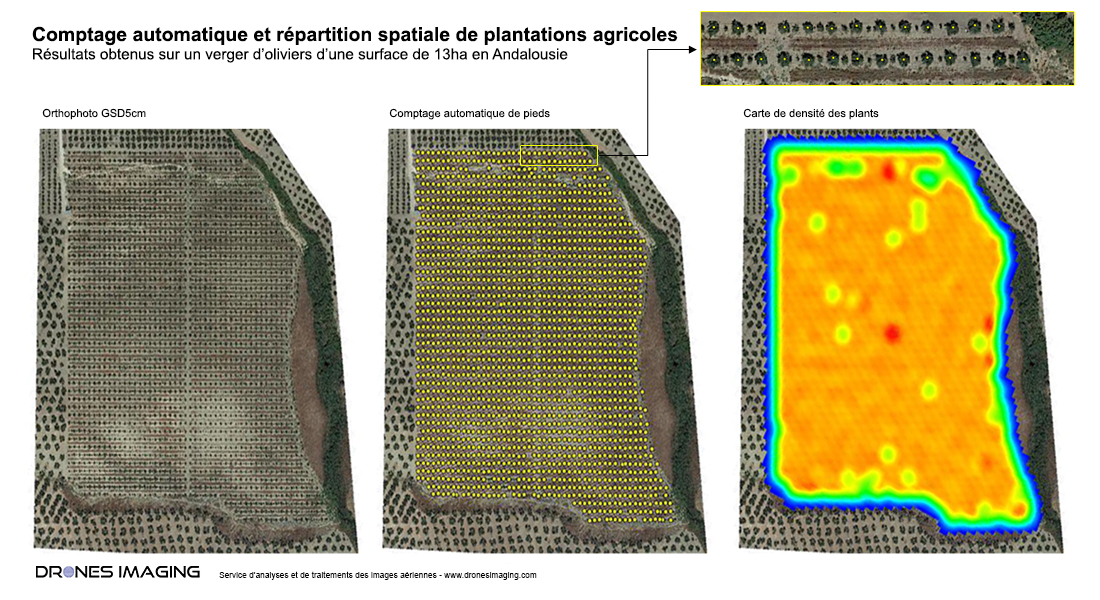
Counting by machine learning, results obtained from a drone on a plot of olive trees of 13ha in Andalusia. Summary plan built in Pdf and Dwg formats, dedicated to the analysis of the spatial distribution of the 1948 plantations detected by machine learning.

Automatic counting by machine learning and study of trees spatial distribution

Automatic counting by machine learning

Machine learning is a field of study of artificial intelligence that uses mathematical and statistical approaches to give computers the ability to “learn” from data. It improves their performance in solving tasks without being explicitly programmed for each one. More broadly, it concerns the design, analysis, optimization, development and implementation of such methods.

The arrival of artificial intelligence algorithms, coupled with the availability of satellite or aerial images, sounds like a revolution in the field of cartography. Indeed, it is now relatively quick and inexpensive to build geographic databases from raster data.

TECHNICAL INFORMATIONS

  • Data processing service : Drones Imaging company.
  • Sensor : A7R4 Quad Agrowing.
  • Orthophoto : RVB GSD 5cm.
  • Spatial accuracy : centimeter with GNSS EMLID Reach RS2.
  • Surface totale inspectée : 13ha.
  • Automatic counting : 1948 olive trees counted.
  • Photogrammetry software : Agisoft Metashape.
PrevPrécédentDam inspection – Topographic survey and disorders detection made by drone and aerial photogrammetry
SuivantAgrowing multispectral camera – automatic counting and almonds trees classification in IsraelNext
  • Mentions légales
  • Français
  • English