Skip to content
Services et traitements des images aériennes
Twitter Facebook Linkedin
  • Français
  • English
DRONES IMAGING
  • Drones imaging
    • Who are we
  • images processing service
    • topographic service
    • thermographic service
    • agricultural service
    • automatic counting service
    • Use case
    • Product sheets
    • useful documentation
    • download guide
  • Trainings
    • training in photogrammetry metashape option
    • training in photogrammetry Pix4D option
    • Multispectral training
    • online photogrammetry training
  • Softwares
    • Agisoft Metashape photogrammetry software
    • Undet software
  • RTK Receivers
    • EMLID GNSS RTK Reach RS3
    • EMLID GNSS RTK Reach RS2+
    • Emlid GNSS RTK Reach RX
    • EMLID GNSS RTK Reach RS+
  • Sensors
    • Agrowing Multispectral cameras
  • News
  • Contact us
  • Toggle website search
Menu Close
  • Drones imaging
    • Who are we
  • images processing service
    • topographic service
    • thermographic service
    • agricultural service
    • automatic counting service
    • Use case
    • Product sheets
    • useful documentation
    • download guide
  • Trainings
    • training in photogrammetry metashape option
    • training in photogrammetry Pix4D option
    • Multispectral training
    • online photogrammetry training
  • Softwares
    • Agisoft Metashape photogrammetry software
    • Undet software
  • RTK Receivers
    • EMLID GNSS RTK Reach RS3
    • EMLID GNSS RTK Reach RS2+
    • Emlid GNSS RTK Reach RX
    • EMLID GNSS RTK Reach RS+
  • Sensors
    • Agrowing Multispectral cameras
  • News
  • Contact us
  • Toggle website search

Blog

  1. Home>
  2. geomatics>
  3. Water tower inspection by drone – surface analysis

Water tower inspection by drone – surface analysis

  • January 23, 2019
  • 10:46 am

Water tower inspection by drone and aerial photogrammetry

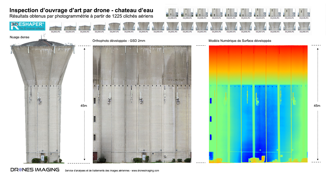
Water tower inspection: results obtained from 1225 aerial images taken by the company D-tection. Post-processing and analyzes  by Drones Imaging.

Surface inspection - 3D model and cylindrical projection

Water tower inspection

Inspection carried out to detect and locate surface defects (concrete break-ups and visible reinforcement rods) on the entire structure.

Flatness analysis of the DSM (Digital Surface Model generated by aerial photogrammetry) allowed the algorithmic detection of wall surface defects (concrete burst) and their classification by severity levels (hole depth). Subsequently, the RGB orthophoto (layered onto the DSM) also allowed the defects to be textured in order to precisely identify their level of gravity (by photo interpretation).

TECHNICAL INFORMATIONS

  • Aerial images processing service : Drones Imaging company.
  • Flights and aerial captation : D-Tection company.
  • Spatial accuracy : centimeter.
  • Orthophoto RVB : GSD 1mm.
  • Drone : DJI Phantom 4.
  • Photogrammetry software : Metashape.
  • Export formats : GéoTiff and Dwg autocad.
  • Delivery delay to the end customer : 2 days.
PrevPrécédentTopographic and bathymetric survey by drone in Corsica
SuivantThermal inspection of photovoltaic panelsNext
  • Mentions légales
  • Français
  • English