Skip to content
Services et traitements des images aériennes
Twitter Facebook Linkedin
  • Français
  • English
DRONES IMAGING
  • Drones imaging
    • Who are we
  • images processing service
    • topographic service
    • thermographic service
    • agricultural service
    • automatic counting service
    • Use case
    • Product sheets
    • useful documentation
    • download guide
  • Trainings
    • training in photogrammetry metashape option
    • training in photogrammetry Pix4D option
    • Multispectral training
    • online photogrammetry training
  • Softwares
    • Agisoft Metashape photogrammetry software
    • Undet software
  • RTK Receivers
    • EMLID GNSS RTK Reach RS3
    • EMLID GNSS RTK Reach RS2+
    • Emlid GNSS RTK Reach RX
    • EMLID GNSS RTK Reach RS+
  • Sensors
    • Agrowing Multispectral cameras
  • News
  • Contact us
  • Toggle website search
Menu Close
  • Drones imaging
    • Who are we
  • images processing service
    • topographic service
    • thermographic service
    • agricultural service
    • automatic counting service
    • Use case
    • Product sheets
    • useful documentation
    • download guide
  • Trainings
    • training in photogrammetry metashape option
    • training in photogrammetry Pix4D option
    • Multispectral training
    • online photogrammetry training
  • Softwares
    • Agisoft Metashape photogrammetry software
    • Undet software
  • RTK Receivers
    • EMLID GNSS RTK Reach RS3
    • EMLID GNSS RTK Reach RS2+
    • Emlid GNSS RTK Reach RX
    • EMLID GNSS RTK Reach RS+
  • Sensors
    • Agrowing Multispectral cameras
  • News
  • Contact us
  • Toggle website search

Blog

  1. Home>
  2. geomatics>
  3. Engineering structure inspection by drone

Engineering structure inspection by drone

  • September 18, 2015
  • 4:55 pm

Inspection of the Jonction viaduct in Geneva

Viaduct inspection: photogrammetric restitution of the downstream and upstream facings of the Jonction viaduct (220m), June 2015. Work carried out from 1350 aerial shots taken by AirX3, the leading company in engineering structure inspections in Switzerland.

Extracts

Inspection de viaduc

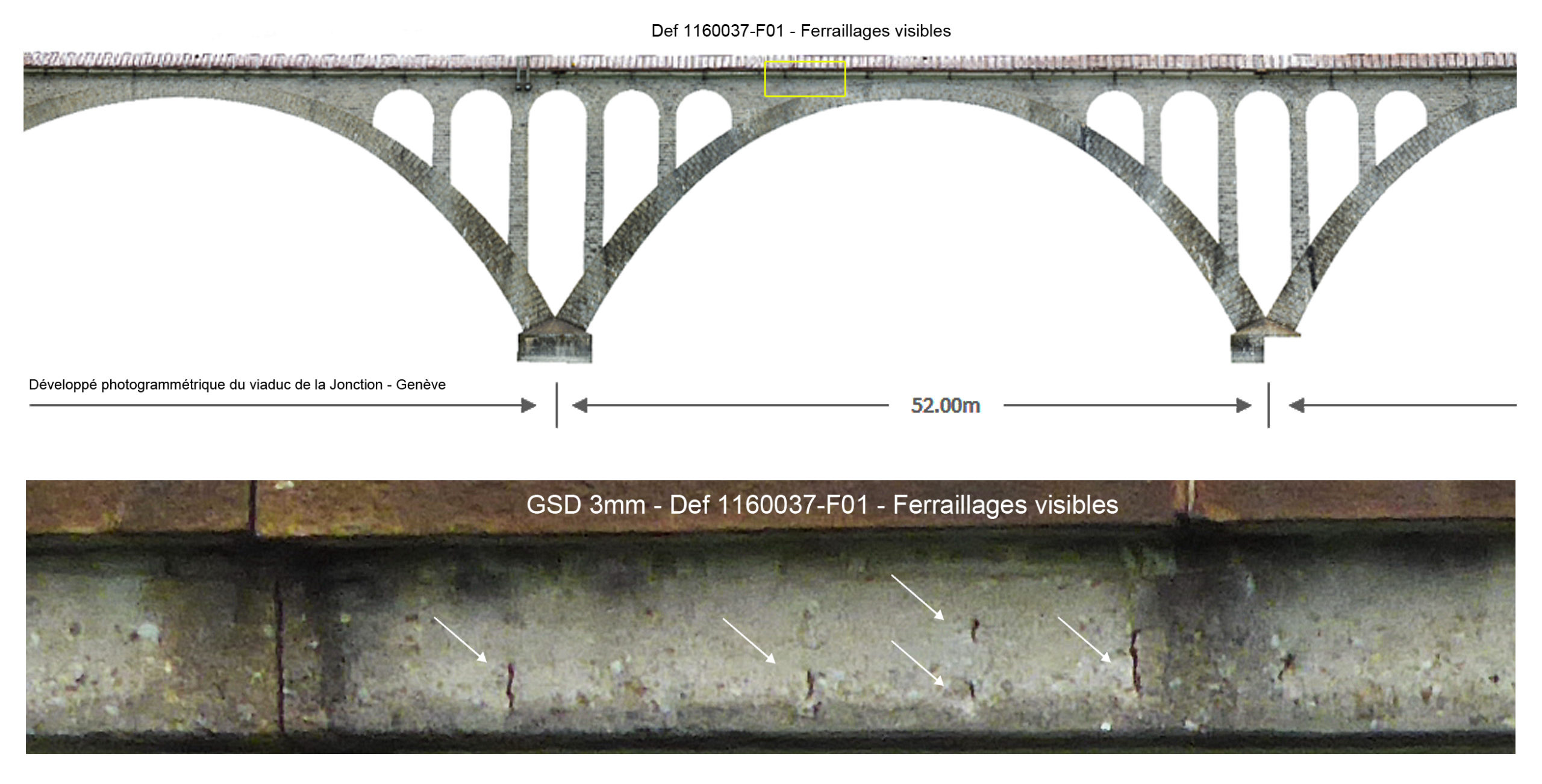
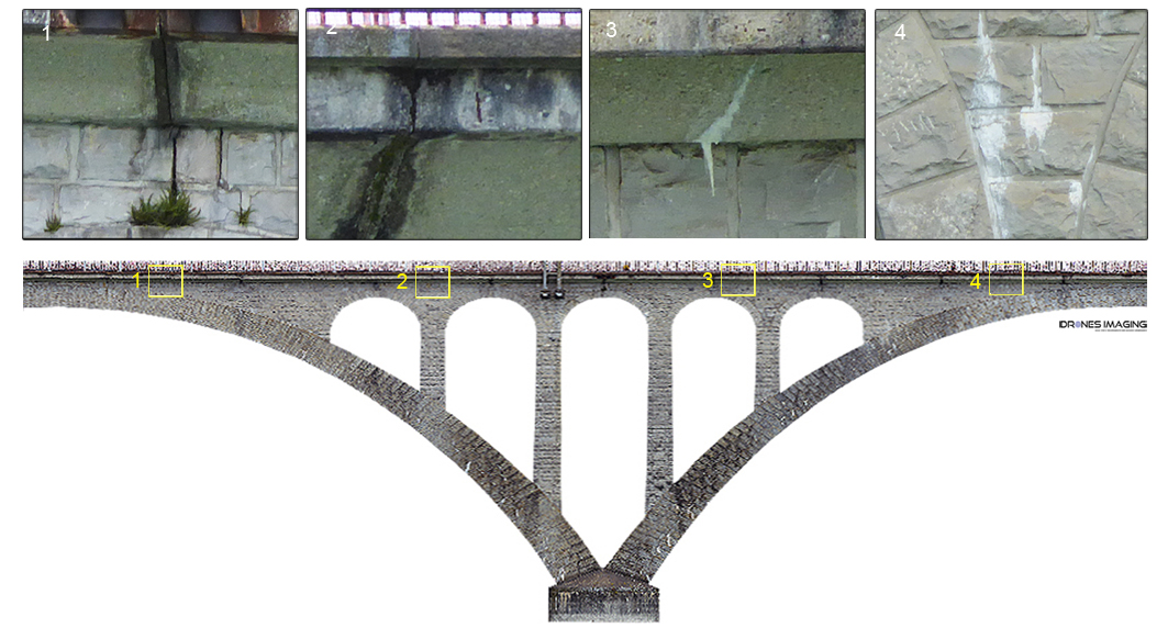
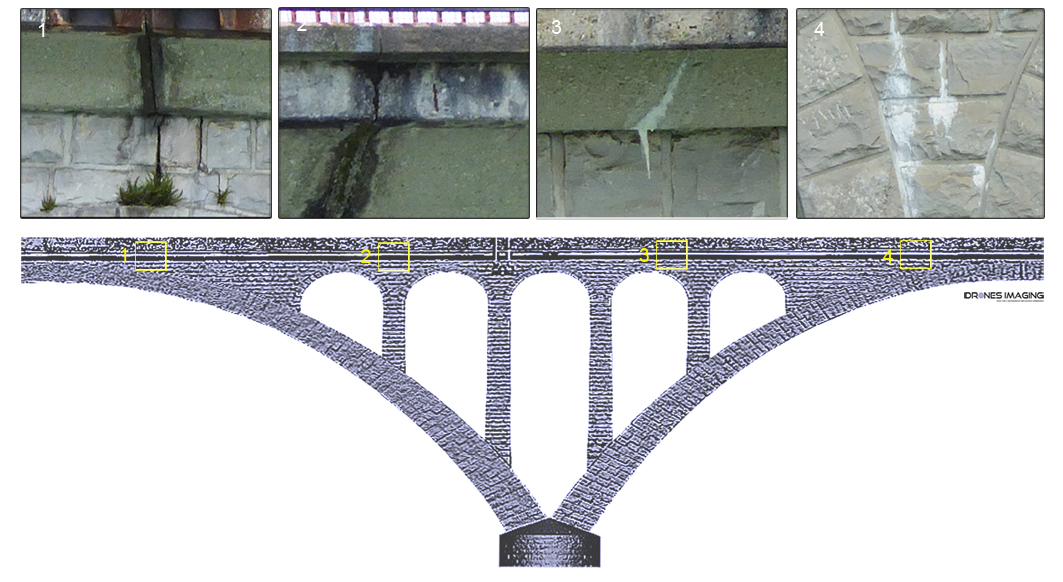
The Jonction viaduct is the eighth most upstream bridge on the Rhône after it leaves Lake Geneva. It is located directly after the meeting of the Rhône and the Arve and connects the district of Saint-Jean on the right bank and the Bois de la Bâtie on the left bank. With this viaduct, automatic flights with the Falcon 8 drone enabled captation of successive images in very high definition (3mm) making it possible to ultimately 3d model the entire viaduct. Thus, the downstream & upstream faces could be analyzed directly from the orthomosaics on which we located all of the following defects:

  • Cracks.
  • Visible reinforcements.
  • Vegetation.
  • Water infiltration.
  • Masonry joints.
  • Calcite.

TECHNICAL INFORMATIONS

  • Aerial imagery post-processing service : Drones Imaging. company.
  • Flights and aerial imagery : AirX3 company.
  • Spatial accuracy : centimeter.
  • Orthophoto RVB : GSD 3mm.
  • Total length inspected : 220m.
  • Drone : Falcon 8.
  • Photogrammetry software : Agisoft Metashape.
  • Export formats : GeoTiff, Shp and Pdf.
  • Delivery delays : 8 days.
  • Use case taught during our photogrammetry training : see more.
PrevPrécédentPreservation of the cultural heritage of Palmyra – Syria.
SuivantTechnical inspection of a refinery performed by droneNext
  • Mentions légales
  • Français
  • English