Skip to content
Services et traitements des images aériennes
Twitter Facebook Linkedin
  • Français
  • English
DRONES IMAGING
  • Drones imaging
    • Who are we
  • images processing service
    • topographic service
    • thermographic service
    • agricultural service
    • automatic counting service
    • Use case
    • Product sheets
    • useful documentation
    • download guide
  • Trainings
    • training in photogrammetry metashape option
    • training in photogrammetry Pix4D option
    • Multispectral training
    • online photogrammetry training
  • Softwares
    • Agisoft Metashape photogrammetry software
    • Undet software
  • RTK Receivers
    • EMLID GNSS RTK Reach RS3
    • EMLID GNSS RTK Reach RS2+
    • Emlid GNSS RTK Reach RX
    • EMLID GNSS RTK Reach RS+
  • Sensors
    • Agrowing Multispectral cameras
  • News
  • Contact us
  • Toggle website search
Menu Close
  • Drones imaging
    • Who are we
  • images processing service
    • topographic service
    • thermographic service
    • agricultural service
    • automatic counting service
    • Use case
    • Product sheets
    • useful documentation
    • download guide
  • Trainings
    • training in photogrammetry metashape option
    • training in photogrammetry Pix4D option
    • Multispectral training
    • online photogrammetry training
  • Softwares
    • Agisoft Metashape photogrammetry software
    • Undet software
  • RTK Receivers
    • EMLID GNSS RTK Reach RS3
    • EMLID GNSS RTK Reach RS2+
    • Emlid GNSS RTK Reach RX
    • EMLID GNSS RTK Reach RS+
  • Sensors
    • Agrowing Multispectral cameras
  • News
  • Contact us
  • Toggle website search

Blog

  1. Home>
  2. geomatics>
  3. Training in remote piloting applied to photogrammetry: facade inspection

Training in remote piloting applied to photogrammetry: facade inspection

  • July 24, 2016
  • 12:14 pm

Specialized training in remote piloting option photogrammetry.

Specialized training in remote piloting: facade inspection exercise for a photogrammetric restitution. Post-processing by Drones Imaging.

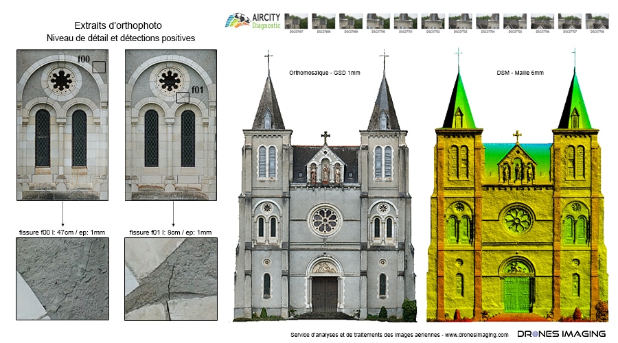
Facade inspection exercise

Specialized training in remote piloting

3D visualization

Benoît Filliatre and Fabrice Prunier have taken technical and operational training in piloting (photogrammetry option) with our partner Flying Eye.

Above are the results obtained after using their images through one of the key subjects of the training: inspections of vertical walls. Results obtained from 277 aerial shots taken under the direction of Loïc Richard. GIS and CAD compatible, these excerpts from digital productions are immediately usable by an architect/surveyor firm. Congratulations to them for the flight plans strategy, the measurements accuracy and above all: the quality of the aerial images provided.

TECHNICAL INFORMATIONS

  • Post-processing service : Drones Imaging company.
  • Spatial accuracy : centimeter.
  • Orthophoto RVB of the facade : GSD 1mm.
  • Drone : Mikrokopter.
  • Camera : Sony A6000.
  • Photogrammetry and 3D modeling software : Agisoft Metashape.
  • Delivery delay : 24h00.
  • Use case taught during our photogrammetry training : see more.
PrevPrécédentTopographic survey made from open source imagery.
SuivantTopographic survey and mapping of the Atlantic high-speed line.Next
  • Mentions légales
  • Français
  • English