Skip to content
Services et traitements des images aériennes
Twitter Facebook Linkedin
  • Français
  • English
DRONES IMAGING
  • Drones imaging
    • Who are we
  • images processing service
    • topographic service
    • thermographic service
    • agricultural service
    • automatic counting service
    • Use case
    • Product sheets
    • useful documentation
    • download guide
  • Trainings
    • training in photogrammetry metashape option
    • training in photogrammetry Pix4D option
    • Multispectral training
    • online photogrammetry training
  • Softwares
    • Agisoft Metashape photogrammetry software
    • Undet software
  • RTK Receivers
    • EMLID GNSS RTK Reach RS3
    • EMLID GNSS RTK Reach RS2+
    • Emlid GNSS RTK Reach RX
    • EMLID GNSS RTK Reach RS+
  • Sensors
    • Agrowing Multispectral cameras
  • News
  • Contact us
  • Toggle website search
Menu Close
  • Drones imaging
    • Who are we
  • images processing service
    • topographic service
    • thermographic service
    • agricultural service
    • automatic counting service
    • Use case
    • Product sheets
    • useful documentation
    • download guide
  • Trainings
    • training in photogrammetry metashape option
    • training in photogrammetry Pix4D option
    • Multispectral training
    • online photogrammetry training
  • Softwares
    • Agisoft Metashape photogrammetry software
    • Undet software
  • RTK Receivers
    • EMLID GNSS RTK Reach RS3
    • EMLID GNSS RTK Reach RS2+
    • Emlid GNSS RTK Reach RX
    • EMLID GNSS RTK Reach RS+
  • Sensors
    • Agrowing Multispectral cameras
  • News
  • Contact us
  • Toggle website search

Blog

  1. Home>
  2. geomatics>
  3. Thermal inspection of photovoltaic panels

Thermal inspection of photovoltaic panels

  • March 7, 2019
  • 12:49 pm

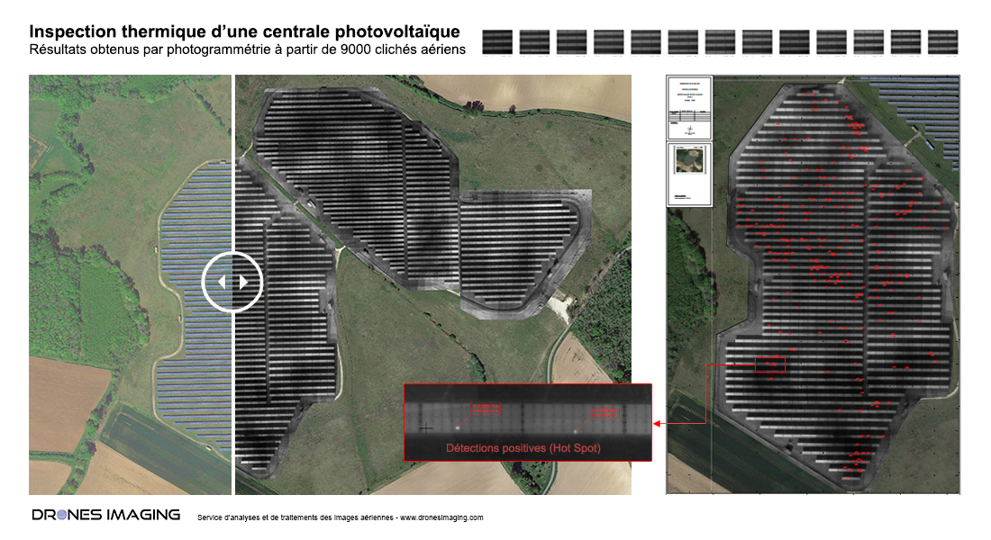
Thermal inspection of solar panels - Detection and localization of hotspot heating for yield losses evaluation.

Thermal inspection: results obtained from 9000 thermograms taken by Tech Drone Service. Post-processing and analysis by Drones Imaging.

Thermal infrared orthophoto built as part of a diagnosis aimed at detecting and locating defective cells that affect the performance of the solar plant.

Thermal orthophoto and hotspot heating detection

Inspection thermique

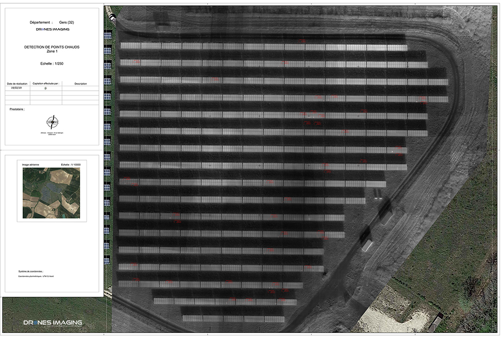
Extract from Autocad map

Below is an extract of deliverable (East area): standardized Autocad plan with tagging of defective cells, panel nomenclature and X-Y-Z georeferencing (decimetric accuracy).

Inspection thermique

TECHNICAL INFORMATIONS

  • Thermal imagery processing service : Drones Imaging company
  • Flights and aerial capture : Tech Drone Service company
  • Spatial accuracy : decimeter.
  • Thermal orthophoto : GSD 6cm
  • Covered area : 19ha
  • Drone : DJI
  • Thermal sensor : Zenmuse XTR
  • Photogrammetry software : Metashape
  • Eport formats : GeoTiff and Dwg autocad
  • Delivery delay : 3 days
PrevPrécédentWater tower inspection by drone – surface analysis
SuivantLong range photogrammetry by gyroplane – Topographic survey of the former Air Base 112 in ReimsNext
  • Mentions légales
  • Français
  • English