Skip to content
Services et traitements des images aériennes
Twitter Facebook Linkedin
  • Français
  • English
DRONES IMAGING
  • Drones imaging
    • Who are we
  • images processing service
    • topographic service
    • thermographic service
    • agricultural service
    • automatic counting service
    • Use case
    • Product sheets
    • useful documentation
    • download guide
  • Trainings
    • training in photogrammetry metashape option
    • training in photogrammetry Pix4D option
    • Multispectral training
    • online photogrammetry training
  • Softwares
    • Agisoft Metashape photogrammetry software
    • Undet software
  • RTK Receivers
    • EMLID GNSS RTK Reach RS3
    • EMLID GNSS RTK Reach RS2+
    • Emlid GNSS RTK Reach RX
    • EMLID GNSS RTK Reach RS+
  • Sensors
    • Agrowing Multispectral cameras
  • News
  • Contact us
  • Toggle website search
Menu Close
  • Drones imaging
    • Who are we
  • images processing service
    • topographic service
    • thermographic service
    • agricultural service
    • automatic counting service
    • Use case
    • Product sheets
    • useful documentation
    • download guide
  • Trainings
    • training in photogrammetry metashape option
    • training in photogrammetry Pix4D option
    • Multispectral training
    • online photogrammetry training
  • Softwares
    • Agisoft Metashape photogrammetry software
    • Undet software
  • RTK Receivers
    • EMLID GNSS RTK Reach RS3
    • EMLID GNSS RTK Reach RS2+
    • Emlid GNSS RTK Reach RX
    • EMLID GNSS RTK Reach RS+
  • Sensors
    • Agrowing Multispectral cameras
  • News
  • Contact us
  • Toggle website search

Blog

  1. Home>
  2. geomatics>
  3. Open source 3D modeling – Paris Charles de Gaulle Airport.

Open source 3D modeling – Paris Charles de Gaulle Airport.

  • February 10, 2017
  • 5:20 pm

Open source 3D modeling of Paris Charles de Gaulle airport

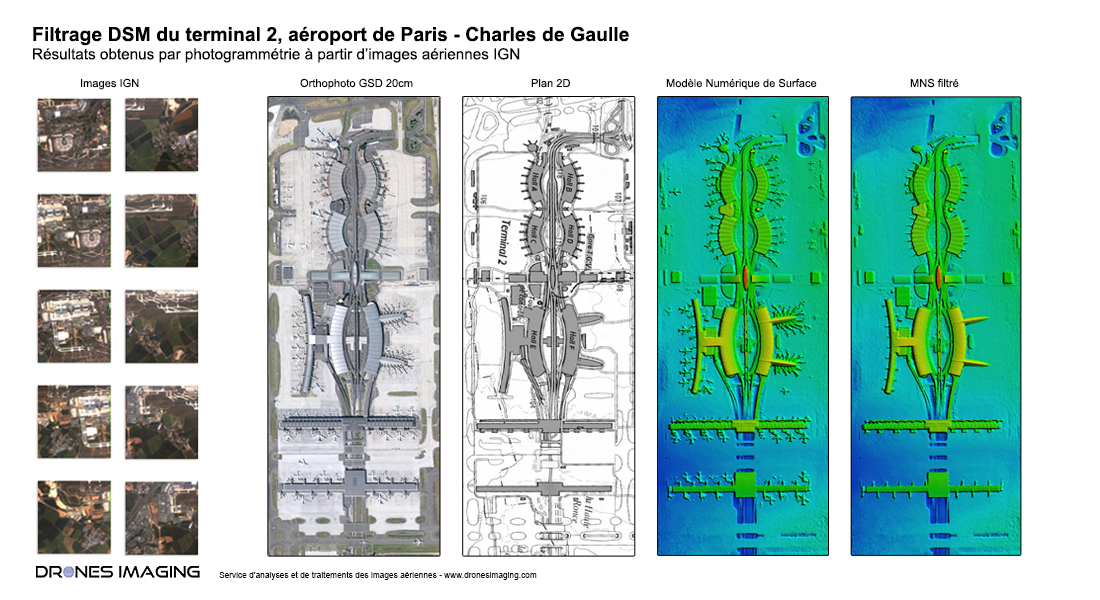
Open source 3D modeling of terminal 2: orthophoto, digital surface model and digital terrain model (filtered without aircraft). Results obtained by photogrammetry from open source aerial imagery available on the IGN historical web portal. Post-processing by Drones Imaging.

Images open source, orthophoto, Plan 2D, Modèle Numérique de Surface et Modèle Numérique de Terrain

Modélisation 3D open source

3D visualization of Terminal 1 at Roissy Charles de Gaulle airport

Service carried out with a view to carrying out inter-visibility calculations between the airport’s infrastructures and acoustic simulations on all the terminals (study of reflection and transmission of sound waves). Through this very specific case study, the filtering of the DSM is necessary to eliminate all temporary elements that can pollute the analysis results (aircraft, access ramps and all service vehicles).

TECHNICAL INFORMATIONS

  • Aerial imagery processing and analysis service : Drones Imaging company.
  • Aerial imagery captation : IGN Institut national de l’information géographique et forestière.
  • Spatial accuracy : below metric.
  • Orthophoto RVB : GSD 10cm.
  • Covered area : 310ha.
  • Photogrammetry software : Metashape.
  • Delivery delay : 48h00.
  • Use case taught during our photogrammetry training : see more.
PrevPrécédentBridge inspection by photogrammetry
SuivantMapping and topographic survey by drone – Cormeilles circuitNext
  • Mentions légales
  • Français
  • English