Skip to content
Services et traitements des images aériennes
Twitter Facebook Linkedin
  • Français
  • English
DRONES IMAGING
  • Drones imaging
    • Who are we
  • images processing service
    • topographic service
    • thermographic service
    • agricultural service
    • automatic counting service
    • Use case
    • Product sheets
    • useful documentation
    • download guide
  • Trainings
    • training in photogrammetry metashape option
    • training in photogrammetry Pix4D option
    • Multispectral training
    • online photogrammetry training
  • Softwares
    • Agisoft Metashape photogrammetry software
    • Undet software
  • RTK Receivers
    • EMLID GNSS RTK Reach RS3
    • EMLID GNSS RTK Reach RS2+
    • Emlid GNSS RTK Reach RX
    • EMLID GNSS RTK Reach RS+
  • Sensors
    • Agrowing Multispectral cameras
  • News
  • Contact us
  • Toggle website search
Menu Close
  • Drones imaging
    • Who are we
  • images processing service
    • topographic service
    • thermographic service
    • agricultural service
    • automatic counting service
    • Use case
    • Product sheets
    • useful documentation
    • download guide
  • Trainings
    • training in photogrammetry metashape option
    • training in photogrammetry Pix4D option
    • Multispectral training
    • online photogrammetry training
  • Softwares
    • Agisoft Metashape photogrammetry software
    • Undet software
  • RTK Receivers
    • EMLID GNSS RTK Reach RS3
    • EMLID GNSS RTK Reach RS2+
    • Emlid GNSS RTK Reach RX
    • EMLID GNSS RTK Reach RS+
  • Sensors
    • Agrowing Multispectral cameras
  • News
  • Contact us
  • Toggle website search

Blog

  1. Home>
  2. geomatics>
  3. Lettuces automatic counting by drone and machine learning

Lettuces automatic counting by drone and machine learning

  • June 24, 2021
  • 3:16 pm

Automatic counting plants by drone from multispectral orthophoto

Automatic counting carried out by machine learning and subsequently, NDVI classification of each plant thanks to the multispectral orthophoto.

(Orthophoto carried out with the aerial images of the Agrowing A7R4 sensor and the Agisoft Metashape software for the post-processing part).

Automatic counting by drone

comptage automatique de plants

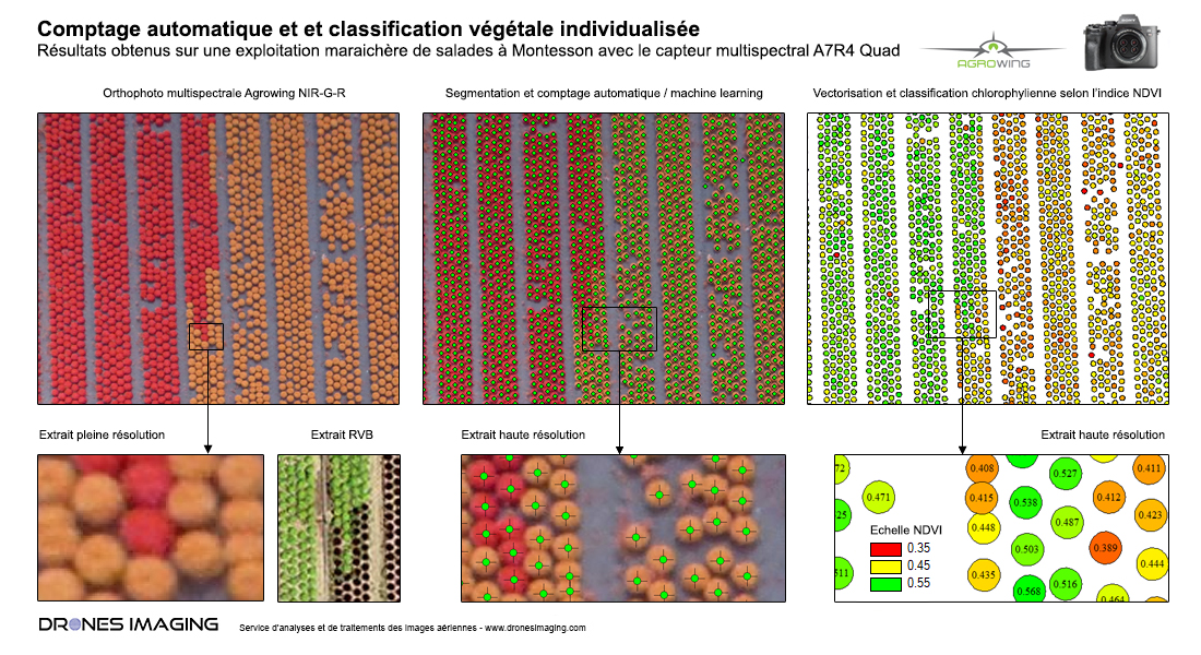
Above, the multispectral orthophoto (NIR-G-R) built with Agisoft Metashape software.

Thanks to the quality and high resolution of the images recorded by the Agrowing multispectral sensor, the orthophoto built at sub-centimeter resolution make it possible to precisely count the number of plants (3675 lettuces in totality from the extract above) and to then classify them according to their relative plant vigor (based on the calculation of the NDVI index).

Thus, it becomes possible to isolate each plant according to their vigor (low or high) and to easily identify, for example, plot areas with low or high yield.

TECHNICAL INFORMATIONS

  • Multispectral image processing service : Drones Imaging.
  • Image processing service for automated counting : Drones Imaging.
  • Spatial accuracy : GPS metric without CORS and without targets.
  • Ground sample distance : 7mm.
  • Surface of the market gardening plot : 1.5ha.
  • Number of plants counted by machine learning : 3675.
  • Photogrammetry software : Metashape.
  • Deliverables : results provided in the form of SHP vector layers or CSV spreadsheet.
PrevPrécédentSurvey map of a parking area built by drone and aerial photogrammetry
SuivantHigh voltage lines inspection: cable extraction and 3D modeling from aerial imagesNext
  • Mentions légales
  • Français
  • English