Skip to content
Services et traitements des images aériennes
Twitter Facebook Linkedin
  • Français
  • English
DRONES IMAGING
  • Drones imaging
    • Who are we
  • images processing service
    • topographic service
    • thermographic service
    • agricultural service
    • automatic counting service
    • Use case
    • Product sheets
    • useful documentation
    • download guide
  • Trainings
    • training in photogrammetry metashape option
    • training in photogrammetry Pix4D option
    • Multispectral training
    • online photogrammetry training
  • Softwares
    • Agisoft Metashape photogrammetry software
    • Undet software
  • RTK Receivers
    • EMLID GNSS RTK Reach RS3
    • EMLID GNSS RTK Reach RS2+
    • Emlid GNSS RTK Reach RX
    • EMLID GNSS RTK Reach RS+
  • Sensors
    • Agrowing Multispectral cameras
  • News
  • Contact us
  • Toggle website search
Menu Close
  • Drones imaging
    • Who are we
  • images processing service
    • topographic service
    • thermographic service
    • agricultural service
    • automatic counting service
    • Use case
    • Product sheets
    • useful documentation
    • download guide
  • Trainings
    • training in photogrammetry metashape option
    • training in photogrammetry Pix4D option
    • Multispectral training
    • online photogrammetry training
  • Softwares
    • Agisoft Metashape photogrammetry software
    • Undet software
  • RTK Receivers
    • EMLID GNSS RTK Reach RS3
    • EMLID GNSS RTK Reach RS2+
    • Emlid GNSS RTK Reach RX
    • EMLID GNSS RTK Reach RS+
  • Sensors
    • Agrowing Multispectral cameras
  • News
  • Contact us
  • Toggle website search

Blog

  1. Home>
  2. geomatics>
  3. Engineering structure inspection by drone: deck intrados.

Engineering structure inspection by drone: deck intrados.

  • May 27, 2016
  • 5:40 pm

Inspection of a deck intrados at the Careï viaduct

Inspection of a deck intrados performed by drone and aerial photogrammetry. 3D modeling and orthophotos generated from 1398 aerial shots taken by drone by the company Flying Eye. Post-processing by Drones Imaging.

3D modeling and detailed orthophoto of the intrados

Inspection of a deck intrados

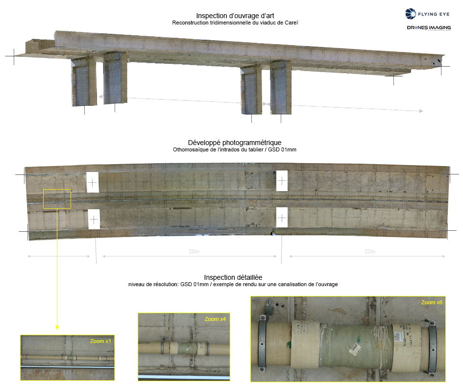
The Careï viaduct is a 521m lenght beam motorway bridge located in Menton (department 06). Above is the orthophoto of the intrados built from 1932 shots (taken under the bridgr in zenith view) and delivered with a 1mm resolution. Service carried out for the benefit of the motorway operator Escota for the detailed inspection of the pipes network and the metal supports under the deck.

TECHNICAL INFORMATIONS

  • Aerial imagery post-processing service : Drones Imaging company.
  • Flights and aerial imagery : Flying Eye company.
  • Spatial accuracy : relative centimeter.
  • Orthophoto RVB : GSD 1mm.
  • Inspected area : 780m².
  • Drone : Hexacopter MK.
  • Camera : Sony A7R.
  • Photogrammetry software : Metashape.
  • Geographic information system : ArcGis.
  • Use case taught in training : see more.

PrevPrécédent3D modeling by videogrammetry: Rabati Castle (Georgia).
SuivantSurvey plan and volumetric calculations produced by aerial photogrammetry.Next
  • Mentions légales
  • Français
  • English