Skip to content
Services et traitements des images aériennes
Twitter Facebook Linkedin
  • Français
  • English
DRONES IMAGING
  • Drones imaging
    • Who are we
  • images processing service
    • topographic service
    • thermographic service
    • agricultural service
    • automatic counting service
    • Use case
    • Product sheets
    • useful documentation
    • download guide
  • Trainings
    • training in photogrammetry metashape option
    • training in photogrammetry Pix4D option
    • Multispectral training
    • online photogrammetry training
  • Softwares
    • Agisoft Metashape photogrammetry software
    • Undet software
  • RTK Receivers
    • EMLID GNSS RTK Reach RS3
    • EMLID GNSS RTK Reach RS2+
    • Emlid GNSS RTK Reach RX
    • EMLID GNSS RTK Reach RS+
  • Sensors
    • Agrowing Multispectral cameras
  • News
  • Contact us
  • Toggle website search
Menu Close
  • Drones imaging
    • Who are we
  • images processing service
    • topographic service
    • thermographic service
    • agricultural service
    • automatic counting service
    • Use case
    • Product sheets
    • useful documentation
    • download guide
  • Trainings
    • training in photogrammetry metashape option
    • training in photogrammetry Pix4D option
    • Multispectral training
    • online photogrammetry training
  • Softwares
    • Agisoft Metashape photogrammetry software
    • Undet software
  • RTK Receivers
    • EMLID GNSS RTK Reach RS3
    • EMLID GNSS RTK Reach RS2+
    • Emlid GNSS RTK Reach RX
    • EMLID GNSS RTK Reach RS+
  • Sensors
    • Agrowing Multispectral cameras
  • News
  • Contact us
  • Toggle website search

Blog

  1. Home>
  2. geomatics>
  3. Topographic survey of the dykes at the Bastia port.

Topographic survey of the dykes at the Bastia port.

  • March 20, 2017
  • 3:45 pm

Dikes inspection by drone in the port of Bastia.

Dikes inspection by drone: results obtained from 840 aerial images taken by the company Aaérodronescorse. Post-processing by Drones Imaging.

Topographic survey of the dykes in the Bastia port

dykes inspection

3D visualization of the jetée du Dragon

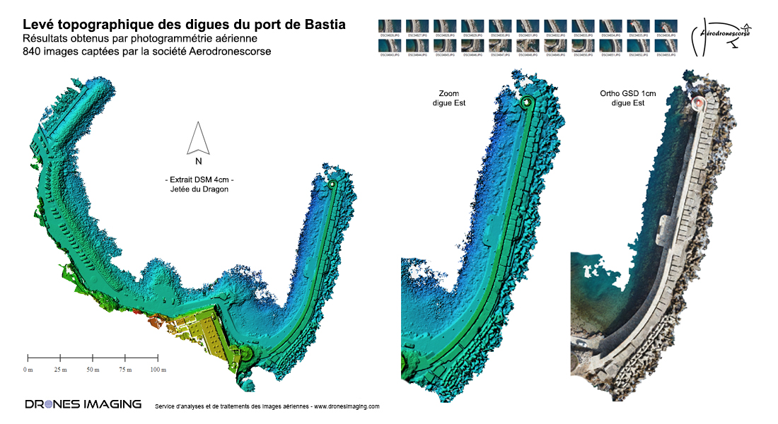
Topographical survey intended to ensure, over time, the proper structural monitoring of the dykes throughout the port of Bastia.
2800 linear meters modeled by aerial photogrammetry and delivered in the form of points cloud with centimeter spatial precision.

TECHNICAL INFORMATIONS

  • Post-processing service : Drones Imaging company.
  • Flights and aerial imagery captation : Aerodroescorse company.
  • Spatial accuracy : centimeter.
  • Orthophoto RVB : GSD 1cm.
  • Length of dikes inspected : 2800m.
  • Drone : Mikrokopter.
  • Camera : Sony A7R.
  • 3D modeling software : Agisoft Metashape.
  • Delivery delay : 24h00.
  • Use case taught during our photogrammetry training : see more.
PrevPrécédentMapping and topographic survey by drone – Cormeilles circuit
SuivantVolume calculation of cuttings and embankments for a quarry rehabilitationNext
  • Mentions légales
  • Français
  • English