Skip to content
Services et traitements des images aériennes
Twitter Facebook Linkedin
  • Français
  • English
DRONES IMAGING
  • Drones imaging
    • Who are we
  • images processing service
    • topographic service
    • thermographic service
    • agricultural service
    • automatic counting service
    • Use case
    • Product sheets
    • useful documentation
    • download guide
  • Trainings
    • training in photogrammetry metashape option
    • training in photogrammetry Pix4D option
    • Multispectral training
    • online photogrammetry training
  • Softwares
    • Agisoft Metashape photogrammetry software
    • Undet software
  • RTK Receivers
    • EMLID GNSS RTK Reach RS3
    • EMLID GNSS RTK Reach RS2+
    • Emlid GNSS RTK Reach RX
    • EMLID GNSS RTK Reach RS+
  • Sensors
    • Agrowing Multispectral cameras
  • News
  • Contact us
  • Toggle website search
Menu Close
  • Drones imaging
    • Who are we
  • images processing service
    • topographic service
    • thermographic service
    • agricultural service
    • automatic counting service
    • Use case
    • Product sheets
    • useful documentation
    • download guide
  • Trainings
    • training in photogrammetry metashape option
    • training in photogrammetry Pix4D option
    • Multispectral training
    • online photogrammetry training
  • Softwares
    • Agisoft Metashape photogrammetry software
    • Undet software
  • RTK Receivers
    • EMLID GNSS RTK Reach RS3
    • EMLID GNSS RTK Reach RS2+
    • Emlid GNSS RTK Reach RX
    • EMLID GNSS RTK Reach RS+
  • Sensors
    • Agrowing Multispectral cameras
  • News
  • Contact us
  • Toggle website search

Blog

  1. Home>
  2. geomatics>
  3. Auscultation of a water tower walls by drone and automatic damages detection

Auscultation of a water tower walls by drone and automatic damages detection

  • April 17, 2018
  • 10:18 am

BIM inspection by drone and automatic detection of disorders

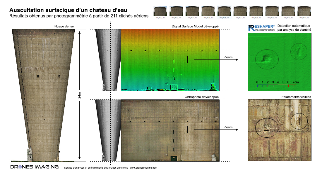
BIM inspection by drone: results obtained from 211 aerial shots taken by the company Adeole, post-processing and data analysis by Drones Imaging. Service carried out as part of a study aimed at detecting and locating surface bursts on the entire water tower.

Cylindrical projection of the orthophoto and Digital Surface Model

BIM inspection by drone

Circular inspection carried out as part of a study aimed to automate areal damages detection.

Job done with the 3DReshaper software and its flatness analysis tool of the Digital Surface Model (DSM generated by aerial photogrammetry) allowed the algorithmic detection of about ten holes on the external concrete structure and their classification by gravity levels (depth holes) and height (by altimetric coordinate). Subsequently, the RGB orthophoto (layered with DSM) also allowed to precisely identify the damages nature. For example and as illustrated above: bursting of concrete with corroded apparent reinforcement constituting a major danger for the durability of the structure..

A very good use case with a semi-automated workflow where MNS and Orthophoto are complementary: the first used for the damages detection and the second for the pathologies interpretation.

TECHNICAL INFORMATIONS

  • Post processing and data analysis service : Drones Imaging.
  • Flights and aerial imagery captation : Adeole.
  • Spatial accuracy : centimeter.
  • Orthophoto RVB : GSD 1mm.
  • Total inspected area : 950m².
  • Drone : Matrice 200.
  • Photogrammetry software : Agisoft Metashape.
  • Export formats : GéoTiff & Dwg autocad.
  • Delivery delay : 2 days.
PrevPrécédentTechnological risks study by drone – flow analysis and simulation of pollutants dispersion.
SuivantInspection of structures by drone – circularity study of a water towerNext
  • Mentions légales
  • Français
  • English