Skip to content
Services et traitements des images aériennes
Twitter Facebook Linkedin
  • Français
  • English
DRONES IMAGING
  • Drones imaging
    • Who are we
  • images processing service
    • topographic service
    • thermographic service
    • agricultural service
    • automatic counting service
    • Use case
    • Product sheets
    • useful documentation
    • download guide
  • Trainings
    • training in photogrammetry metashape option
    • training in photogrammetry Pix4D option
    • Multispectral training
    • online photogrammetry training
  • Softwares
    • Agisoft Metashape photogrammetry software
    • Undet software
  • RTK Receivers
    • EMLID GNSS RTK Reach RS3
    • EMLID GNSS RTK Reach RS2+
    • Emlid GNSS RTK Reach RX
    • EMLID GNSS RTK Reach RS+
  • Sensors
    • Agrowing Multispectral cameras
  • News
  • Contact us
  • Toggle website search
Menu Close
  • Drones imaging
    • Who are we
  • images processing service
    • topographic service
    • thermographic service
    • agricultural service
    • automatic counting service
    • Use case
    • Product sheets
    • useful documentation
    • download guide
  • Trainings
    • training in photogrammetry metashape option
    • training in photogrammetry Pix4D option
    • Multispectral training
    • online photogrammetry training
  • Softwares
    • Agisoft Metashape photogrammetry software
    • Undet software
  • RTK Receivers
    • EMLID GNSS RTK Reach RS3
    • EMLID GNSS RTK Reach RS2+
    • Emlid GNSS RTK Reach RX
    • EMLID GNSS RTK Reach RS+
  • Sensors
    • Agrowing Multispectral cameras
  • News
  • Contact us
  • Toggle website search

Blog

  1. Home>
  2. geomatics>
  3. Building Information Model by terrestrial photogrammetry

Building Information Model by terrestrial photogrammetry

  • February 27, 2016
  • 11:35 am

3D Modeling by terrestrial photogrammetry

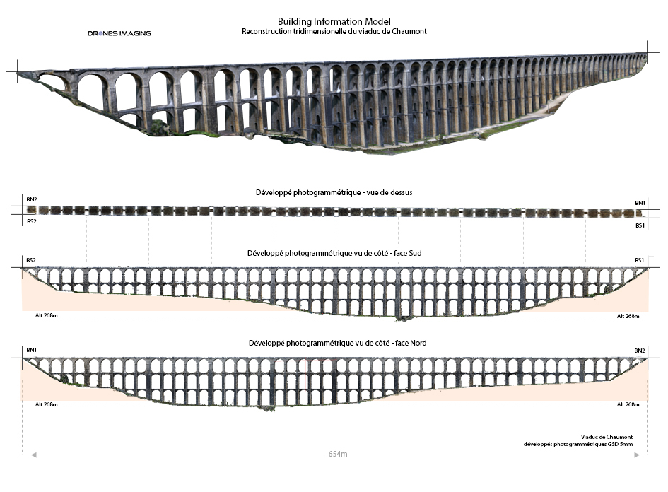
3D Modeling by terrestrial photogrammetry: BIM (Building Information Model) of the Chaumont viaduct located at kilometer point (PK) 260.757 of the Paris-East line to Mulhouse. Results obtained from 5900 terrestrial shots, without any aerial means.

3D modeling of the Chaumont viaduct, top view and right/left views

3D Modeling by terrestrial photogrammetry

3D Visualization

TECHNICAL INFORMATIONS

  • Image processing and analysis service : Drones Imaging company.
  • Terrestrial shooting : Drones Imaging company.
  • Spatial accuracy : decimeter.
  • Orthophotos RVB : GSD 5mm.
  • Length : 654m.
  • Height : 52m.
  • Camera : Sony RX100 III.
  • Photogrammetry software : Agisoft Metashape.
  • Export formats : GeoTiff, Obj and Las.
  • Delivery delay : 7 days.
PrevPrécédent3D modeling of the Pic du Midi d’Ossau on the occasion of the 70th anniversary of the UNGE (National Union of Expert Surveyors).
SuivantTopographical survey and quarry planNext
  • Mentions légales
  • Français
  • English