Skip to content
Services et traitements des images aériennes
Twitter Facebook Linkedin
  • Français
  • English
DRONES IMAGING
  • Drones imaging
    • Who are we
  • images processing service
    • topographic service
    • thermographic service
    • agricultural service
    • automatic counting service
    • Use case
    • Product sheets
    • useful documentation
    • download guide
  • Trainings
    • training in photogrammetry metashape option
    • training in photogrammetry Pix4D option
    • Multispectral training
    • online photogrammetry training
  • Softwares
    • Agisoft Metashape photogrammetry software
    • Undet software
  • RTK Receivers
    • EMLID GNSS RTK Reach RS3
    • EMLID GNSS RTK Reach RS2+
    • Emlid GNSS RTK Reach RX
    • EMLID GNSS RTK Reach RS+
  • Sensors
    • Agrowing Multispectral cameras
  • News
  • Contact us
  • Toggle website search
Menu Close
  • Drones imaging
    • Who are we
  • images processing service
    • topographic service
    • thermographic service
    • agricultural service
    • automatic counting service
    • Use case
    • Product sheets
    • useful documentation
    • download guide
  • Trainings
    • training in photogrammetry metashape option
    • training in photogrammetry Pix4D option
    • Multispectral training
    • online photogrammetry training
  • Softwares
    • Agisoft Metashape photogrammetry software
    • Undet software
  • RTK Receivers
    • EMLID GNSS RTK Reach RS3
    • EMLID GNSS RTK Reach RS2+
    • Emlid GNSS RTK Reach RX
    • EMLID GNSS RTK Reach RS+
  • Sensors
    • Agrowing Multispectral cameras
  • News
  • Contact us
  • Toggle website search

Blog

  1. Home>
  2. geomatics>
  3. Roof thermal inspection and diagnostics by drone

Roof thermal inspection and diagnostics by drone

  • May 11, 2017
  • 4:20 am

Roof energy audit carried out by drone

Roof energy audit by thermal infrared aerial capture carried out on April 21, 2017 by the company Drones Images. Analysis and post-processing service by Drones Imaging.

Thermal and radiometric orthophoto of a building roof

Roof energy audit

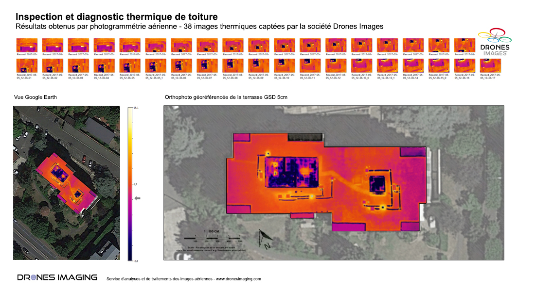
Results obtained from 38 thermal infrared images for the detection and localization of heat loss through the terrace of the building (length 40m, width 15m).

TECHNICAL INFORMATIONS

  • Aerial imagery post processing service : Drones Imaging company.
  • Flights and aerial imagery captation : Drones Images company.
  • Spatial accuracy : decimeter.
  • Sensor : camera Optris.
  • Radiometric orthophoto : GSD 5cm.
  • Roof surface inspected : 600m².
  • Range thermal sensor : -1°C / 16°C.
  • Photogrammetry software : Metashape.
  • Use case taught during our Agisoft Metashape training : see more.
PrevPrécédentMining industry: motorable tracks study for the benefit of Volvo France.
SuivantInspection of a water tower by drone & cracks detectionNext
  • Mentions légales
  • Français
  • English