Technological risks study by drone - flow analysis and simulation of pollutants dispersion.
Technological risks study by drone : results obtained from 2068 aerial images taken by D-Tection, company specialized in aerial inspections by drones. Post processing and data analysis by Drones Imaging.
Flow analysis by drone
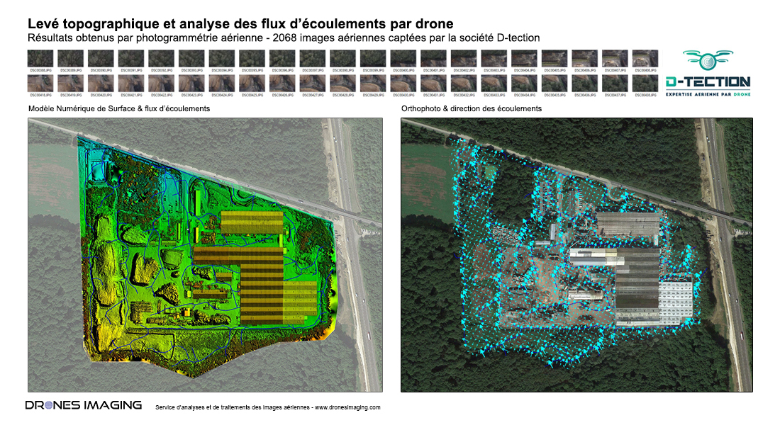
Following a fire inside its production site, the Kronospan company, specialized in the manufacture of plywoods made contact with the companies D-tection and Drones Imaging to model the entire right-of-way of the plant and thus analyze, through numerical simulations, the multiple paths of water discharged by firefighters during fight against fire.
Thanks to Metashape software, the 2068 aerial images taken by the company D-Tection were used to 3D modeling the entire site allowing a faithful representation of the terrain: DSM (Digital Surface Model). The DSM thus built (whith 1cm spatial accuracy) has made it possible to simulate the waters flows discharged by civil security during the fire, to analyze their direction and to ultimately locate: the dispersal zones in the nature, where pollutants related to the activity of the factory have been scattered.
Following this dispersal of pollutants and on the order of the DREAL (Regional Directorate for the Environment, Planning and Housing), the Kronospan site will soon begin the upgrading of its storage platform by realizing new watersheds for rainwater harvesting. Thus, the MNS generated for the simulations will also be used for survey and dimensioning the future retention ponds (surfaces and depths).
Seduced by the speed and accuracy of the results obtained, the rescue services also showed a keen interest in this new use case allowing to locate potential areas of pollution following disasters or accidents with loss of fluids.
3D visualization
TECHNICAL INFORMATIONS
- Data processing and analysis service : Drones Imaging company.
- Flights and aerial imagery captation : D-Tection company.
- Spatial accuracy : centimeter.
- Orthophoto RVB : GSD 9mm.
- Covered area : 34ha.
- Drone : MK.
- Sensor : Sony A6000.
- Photogrammetry software : Agisoft Metashape.
- Export formats : GeoTiff, Shp ans Kmz.
- Delivery delay : 2 days.