Photogrammetry by gyroplane and topographic survey carried out for coastal erosion monitoring
Photogrammetry by gyroplane: mapping and 3D modeling of a 25km corridor for monitoring beach erosion in Corsica. Results obtained from 1840 aerial shots taken by gyroplane.
The Territorial Collectivity of Corsica (CTC, in charge Corsica beaches monitoring) called on the companies Aerodronescorse and Drones Imaging for 3D modeling 25 km of coastline between the agglomerations of Bastia and Casamozza.
To carry out this first aerial topographical survey of 25 km, the gyroplane has been naturally privileged. Indeed, its flexibility of use, its endurance and payload capacity make it an airborne platform particularly adapted on this type of mission. 30mn only have sufficed by gyroplane to cover the entire 25Km of the coastline while capturing more than 1800 aerial images.
With 1050 km of coast, Corsica has a very diversified coastline. But in recent years, urbanization and infrastructures have developed considerably onto the coast and some residences are now threatened in the face of global warming and erosion phenomenas. In this context and in anticipation of future submersions that are harmful to populations and the local economy, the CTC commissioned a complete modeling of the coastline in order to study its smallest aspects.
Topographic survey carried out by gyroplane
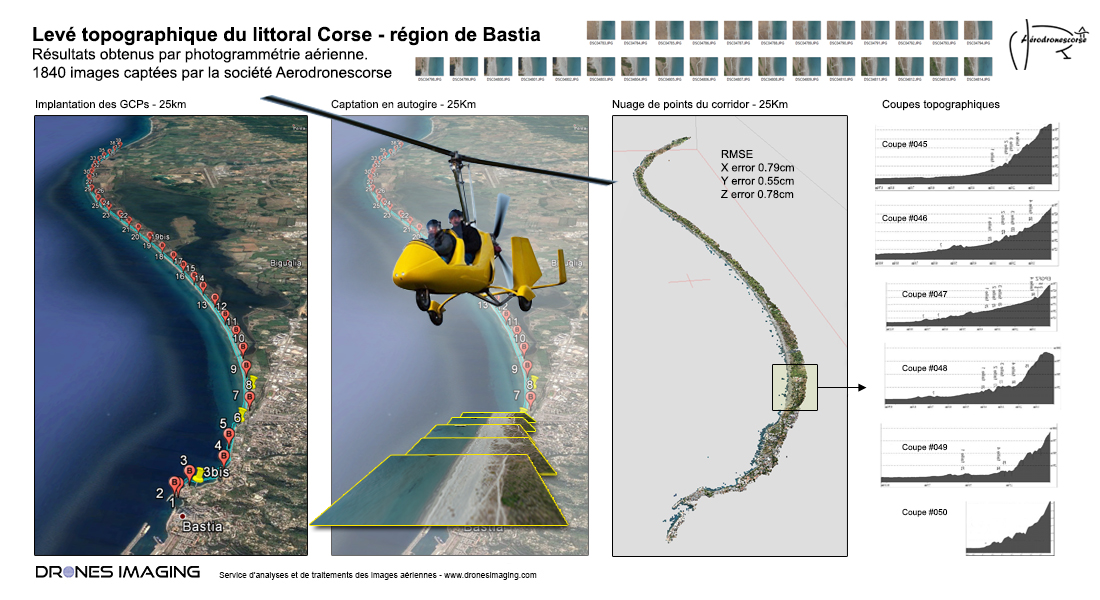
Subsequently, and thanks to the photogrammetry , these aerial photographs were used to build a dense cloud (1pt every 15cm) allowing a very faithful 3D representation of the coast. The 3D model thus generated and whose spatial accuracy is a few centimeters (accuracy obtained thanks to the targets previously put on the terrain and measured by GNSS RTK) immediately allowed the CTC to automatically extract topographic profiles on the the whole corridor. If these topographic profiles already constitute an excellent support for studying the morphology of the beaches, they will also serve as an initial reference for ultimately measuring beaches evolution over time. Indeed, thanks to future aerial acquisitions and by temporal comparison, it will be possible to locate and quantify automatically: the sectors where there has been a gain or loss of terrain.
As a result of the success of this first operation, future missions are planned in the short term but this time, over much greater distances. Thus, the CTC will soon have full digital supports to undertake preventive and targeted management of coastal erosion in Corsica.
TECHNICAL INFORMATIONS
- Post processing service : Drones Imaging company.
- Flights and aerial imagery captation : Aérodronescorse & Drones Imaging companies.
- Spatial accuracy : centimétrique RTK.
- Orthophoto RVB : GSD 3cm.
- Dense cloud : 15cm.
- Beach length inspected : 25Km.
- Airborne platform : Gyroplane.
- Cameras : SONY RX100
- Photogrammetry software : Agisoft Metashape.
- Geographic Information System : ArcGis.