Skip to content
Services et traitements des images aériennes
Twitter Facebook Linkedin
  • Français
  • English
DRONES IMAGING
  • Drones imaging
    • Who are we
  • images processing service
    • topographic service
    • thermographic service
    • agricultural service
    • automatic counting service
    • Use case
    • Product sheets
    • useful documentation
    • download guide
  • Trainings
    • training in photogrammetry metashape option
    • training in photogrammetry Pix4D option
    • Multispectral training
    • online photogrammetry training
  • Softwares
    • Agisoft Metashape photogrammetry software
    • Undet software
  • RTK Receivers
    • EMLID GNSS RTK Reach RS3
    • EMLID GNSS RTK Reach RS2+
    • Emlid GNSS RTK Reach RX
    • EMLID GNSS RTK Reach RS+
  • Sensors
    • Agrowing Multispectral cameras
  • News
  • Contact us
  • Toggle website search
Menu Close
  • Drones imaging
    • Who are we
  • images processing service
    • topographic service
    • thermographic service
    • agricultural service
    • automatic counting service
    • Use case
    • Product sheets
    • useful documentation
    • download guide
  • Trainings
    • training in photogrammetry metashape option
    • training in photogrammetry Pix4D option
    • Multispectral training
    • online photogrammetry training
  • Softwares
    • Agisoft Metashape photogrammetry software
    • Undet software
  • RTK Receivers
    • EMLID GNSS RTK Reach RS3
    • EMLID GNSS RTK Reach RS2+
    • Emlid GNSS RTK Reach RX
    • EMLID GNSS RTK Reach RS+
  • Sensors
    • Agrowing Multispectral cameras
  • News
  • Contact us
  • Toggle website search

Blog

  1. Home>
  2. geomatics>
  3. Photogrammetry & multi-color 3D printing of the Pic du midi d’Ossau

Photogrammetry & multi-color 3D printing of the Pic du midi d’Ossau

  • September 19, 2016
  • 3:45 pm

Colorized 3D printing of the Pic du midi d'Ossau

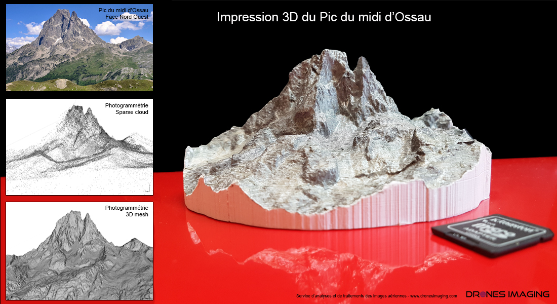
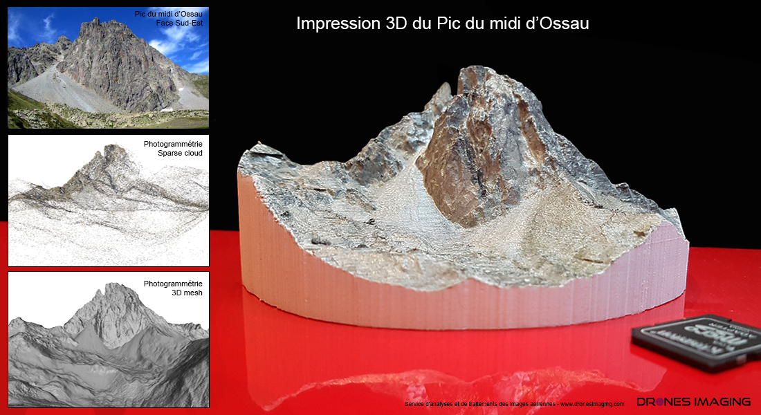
Photogrammetry and 3D printing of the Pic du midi d’Ossau. 3D model made with Agisoft Metashape software and printed in very high resolution by our partner Fabrice Louis, specialist in professional 3D design and printing. Below is the colorized 3D model of the Pic du midi d’Ossau. Result obtained with the MCOR IRIS printer whose technology is based on successively A4 paper sticking with special binder.

Photogrammetry and 3D printing

Photogrammetry and 3D printing

3D model of the Pic du Midi d'Ossau

TECHNICAL INFORMATIONS

  • Aerial imagery post processing service : Drones Imaging company.
  • 3D printing: MCOR IRIS.
  • Size of the model : 15cm in diameter.
  • Axial resolution (X,Y,Z) : 12µ,12µ,100µ.
  • Printing time : 34h.
  • Number of A4 sheets used : 676.
  • Photogrammetry software : Agisoft Metashape.
  • Seen in training : see more.
PrevPrécédentTopographic survey and mapping by drone of the Maman Valentin dam (Guyana).
Suivant3D modeling by terrestrial photographic captureNext
  • Mentions légales
  • Français
  • English