Skip to content
Services et traitements des images aériennes
Twitter Facebook Linkedin
  • Français
  • English
DRONES IMAGING
  • Drones imaging
    • Who are we
  • images processing service
    • topographic service
    • thermographic service
    • agricultural service
    • automatic counting service
    • Use case
    • Product sheets
    • useful documentation
    • download guide
  • Trainings
    • training in photogrammetry metashape option
    • training in photogrammetry Pix4D option
    • Multispectral training
    • online photogrammetry training
  • Softwares
    • Agisoft Metashape photogrammetry software
    • Undet software
  • RTK Receivers
    • EMLID GNSS RTK Reach RS4 PRO
    • EMLID GNSS RTK Reach RS4
    • EMLID GNSS RTK Reach RX2
    • EMLID GNSS RTK Reach RS3
    • Emlid GNSS RTK Reach RX
  • Sensors
    • Agrowing Multispectral cameras
  • News
  • Contact us
  • Toggle website search
Menu Close
  • Drones imaging
    • Who are we
  • images processing service
    • topographic service
    • thermographic service
    • agricultural service
    • automatic counting service
    • Use case
    • Product sheets
    • useful documentation
    • download guide
  • Trainings
    • training in photogrammetry metashape option
    • training in photogrammetry Pix4D option
    • Multispectral training
    • online photogrammetry training
  • Softwares
    • Agisoft Metashape photogrammetry software
    • Undet software
  • RTK Receivers
    • EMLID GNSS RTK Reach RS4 PRO
    • EMLID GNSS RTK Reach RS4
    • EMLID GNSS RTK Reach RX2
    • EMLID GNSS RTK Reach RS3
    • Emlid GNSS RTK Reach RX
  • Sensors
    • Agrowing Multispectral cameras
  • News
  • Contact us
  • Toggle website search

News

  1. Home>
  2. News>
  3. Page 5

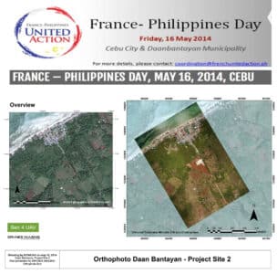
Ben4uav & Drones Imaging support the Philippines with...

  • geomatics
  • May 29, 2014
Drone and humanitarian aid in the Philippines for the benefit of the Croix Rouge Drone and humanitarian aid in
Continuer la lecture
NDVI

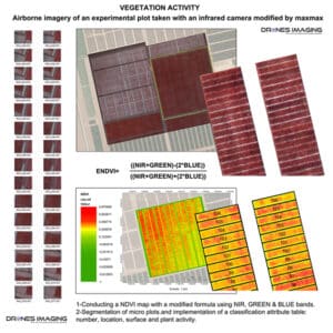
NDVI for estimating crop health and biomass

  • geomatics
  • March 30, 2014
NDVI Vegetation Index NDVI Vegetation Index: aerial images collection made on an experimental agricultural plot with a drone and
Continuer la lecture
3D Starimost

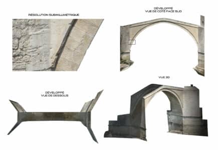
3D modeling and photogrammetric inspection of the Mostar...

  • geomatics
  • August 18, 2013
Mostar bridge inspection – Stari Most Bridge inspection: 3D modeling and orthofaces of the old Mostar bridge built with
Continuer la lecture
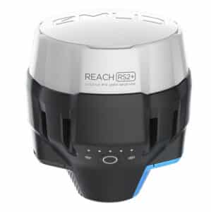
Official French dealer of EMLID brand

  • gnss rtk
  • January 1, 2013
EMLID Official dealer New generation Emlid Reach RS3 New generation of 5G compatible receivers. Centimeter accuracy for professional applications
Continuer la lecture
>