Skip to content
Services et traitements des images aériennes
Twitter Facebook Linkedin
  • Français
  • English
DRONES IMAGING
  • Drones imaging
    • Who are we
  • images processing service
    • topographic service
    • thermographic service
    • agricultural service
    • automatic counting service
    • Use case
    • Product sheets
    • useful documentation
    • download guide
  • Trainings
    • training in photogrammetry metashape option
    • training in photogrammetry Pix4D option
    • Multispectral training
    • online photogrammetry training
  • Softwares
    • Agisoft Metashape photogrammetry software
    • Undet software
  • RTK Receivers
    • EMLID GNSS RTK Reach RS3
    • EMLID GNSS RTK Reach RS2+
    • Emlid GNSS RTK Reach RX
    • EMLID GNSS RTK Reach RS+
  • Sensors
    • Agrowing Multispectral cameras
  • News
  • Contact us
  • Toggle website search
Menu Close
  • Drones imaging
    • Who are we
  • images processing service
    • topographic service
    • thermographic service
    • agricultural service
    • automatic counting service
    • Use case
    • Product sheets
    • useful documentation
    • download guide
  • Trainings
    • training in photogrammetry metashape option
    • training in photogrammetry Pix4D option
    • Multispectral training
    • online photogrammetry training
  • Softwares
    • Agisoft Metashape photogrammetry software
    • Undet software
  • RTK Receivers
    • EMLID GNSS RTK Reach RS3
    • EMLID GNSS RTK Reach RS2+
    • Emlid GNSS RTK Reach RX
    • EMLID GNSS RTK Reach RS+
  • Sensors
    • Agrowing Multispectral cameras
  • News
  • Contact us
  • Toggle website search

Blog

  1. Home>
  2. geomatics>
  3. 3D modeling of a tourist residence by coupling laser and photogrammetric data

3D modeling of a tourist residence by coupling laser and photogrammetric data

  • November 15, 2017
  • 10:18 am

Laser and photogrammetry data merge: 3D modeling of a tourist residence by coupling aerial and terrestrial points cloud

Laser and photogrammetry data merge: Roof 3D modeling by aerial photogrammetry and merging with a points cloud built by laser scanner. Results obtained from 314 RGB images taken by Altitude Drone Diagnostic. Post-processing by Drones Imaging.

Aerial and terrestrial points clouds merged

Laser & photogrammetry data merge

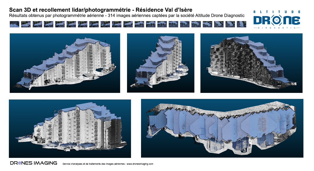
Service carried out as part of the rehabilitation of ski residences in Val d’Isère.

Coupling laser and photogrammetric data makes it possible, in this use case, to fill in all the mask areas inaccessible with laser scanning. Thus, after merging the 2 models BUILT respectively by aerial photogrammetry (drone for the roof part) and terrestrial laser (for the four facades), the first residence in Val d’Isère was fully modeled and delivered for subsequent use in the office of study with Autocad.

TECHNICAL INFORMATIONS

  • Post processing service : Drones Imaging company.
  • Flights and aerial imagery : Altitude Drone Diagnostic company.
  • Spatial accuracy : centimétrique.
  • Orthophoto RVB : GSD 5mm.
  • Covered area : 2350m².
  • Drone : MikroKopter.
  • Camera : SONY ILCE 6000.
  • Softwares used : Agisoft Metashape and Cloud Compare.
  • Export formats : GeoTiff, Las and Dwg autocad.
  • Delivery delay : one day upon receipt of aerial images.
  • Press : see more.
PrevPrécédentWater stress detection by drone and infrared thermography
SuivantFlatness analysis of a swimming pool achieved by drone and aerial photogrammetryNext
  • Mentions légales
  • Français
  • English