Skip to content
Services et traitements des images aériennes
Twitter Facebook Linkedin
  • Français
  • English
DRONES IMAGING
  • Drones imaging
    • Who are we
  • images processing service
    • topographic service
    • thermographic service
    • agricultural service
    • automatic counting service
    • Use case
    • Product sheets
    • useful documentation
    • download guide
  • Trainings
    • training in photogrammetry metashape option
    • training in photogrammetry Pix4D option
    • Multispectral training
    • online photogrammetry training
  • Softwares
    • Agisoft Metashape photogrammetry software
    • Undet software
  • RTK Receivers
    • EMLID GNSS RTK Reach RS3
    • EMLID GNSS RTK Reach RS2+
    • Emlid GNSS RTK Reach RX
    • EMLID GNSS RTK Reach RS+
  • Sensors
    • Agrowing Multispectral cameras
  • News
  • Contact us
  • Toggle website search
Menu Close
  • Drones imaging
    • Who are we
  • images processing service
    • topographic service
    • thermographic service
    • agricultural service
    • automatic counting service
    • Use case
    • Product sheets
    • useful documentation
    • download guide
  • Trainings
    • training in photogrammetry metashape option
    • training in photogrammetry Pix4D option
    • Multispectral training
    • online photogrammetry training
  • Softwares
    • Agisoft Metashape photogrammetry software
    • Undet software
  • RTK Receivers
    • EMLID GNSS RTK Reach RS3
    • EMLID GNSS RTK Reach RS2+
    • Emlid GNSS RTK Reach RX
    • EMLID GNSS RTK Reach RS+
  • Sensors
    • Agrowing Multispectral cameras
  • News
  • Contact us
  • Toggle website search

Blog

  1. Home>
  2. geomatics>
  3. Flood simulation for DREAL

Flood simulation for DREAL

  • August 22, 2017
  • 10:35 am

Flood simulation for dreal (Regional Directorate for the Environment, Planning and Housing)

Flood simulation carried out by aerial photogrammetry on the Loire river, in the commune of Goudet (department 43). Results obtained from 259 aerial shots captured by drone. Post-processing and analysis service by Drones Imaging.

Flood animation: water rise with 20cm increments

Simulation d'inondation

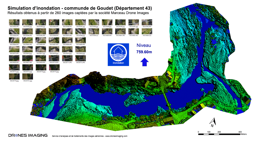
Work carried out for the benefit of the DREAL (Regional Directorate for the Environment, Planning and Housing) as part of the risk prevention plan. Simulation of a rise in water in 20cm increments to measure flood impact on the banks and agglomerations.

TECHNICAL INFORMATIONS

  • Data processing service : Drones Imaging company.
  • Flights and aerial imagery captation : Marceau Drone Images company.
  • Spatial accuracy : RTK centimeter.
  • Orthophoto RVB : GSD 1cm.
  • Drone : MikroKopter.
  • Camera : SONY A6000.
  • Photogrammetry software : Agisoft Metashape.
  • Geographic Information Sytem : ArcGis.
  • Delivery delay : one day upon receipt aerial images to be processed.
PrevPrécédentTopographic survey for coastal erosion monitoring
SuivantWater stress detection by drone and infrared thermographyNext
  • Mentions légales
  • Français
  • English