Skip to content
Services et traitements des images aériennes
Twitter Facebook Linkedin
  • Français
  • English
DRONES IMAGING
  • Drones imaging
    • Who are we
  • images processing service
    • topographic service
    • thermographic service
    • agricultural service
    • automatic counting service
    • Use case
    • Product sheets
    • useful documentation
    • download guide
  • Trainings
    • training in photogrammetry metashape option
    • training in photogrammetry Pix4D option
    • Multispectral training
    • online photogrammetry training
  • Softwares
    • Agisoft Metashape photogrammetry software
    • Undet software
  • RTK Receivers
    • EMLID GNSS RTK Reach RS3
    • EMLID GNSS RTK Reach RS2+
    • Emlid GNSS RTK Reach RX
    • EMLID GNSS RTK Reach RS+
  • Sensors
    • Agrowing Multispectral cameras
  • News
  • Contact us
  • Toggle website search
Menu Close
  • Drones imaging
    • Who are we
  • images processing service
    • topographic service
    • thermographic service
    • agricultural service
    • automatic counting service
    • Use case
    • Product sheets
    • useful documentation
    • download guide
  • Trainings
    • training in photogrammetry metashape option
    • training in photogrammetry Pix4D option
    • Multispectral training
    • online photogrammetry training
  • Softwares
    • Agisoft Metashape photogrammetry software
    • Undet software
  • RTK Receivers
    • EMLID GNSS RTK Reach RS3
    • EMLID GNSS RTK Reach RS2+
    • Emlid GNSS RTK Reach RX
    • EMLID GNSS RTK Reach RS+
  • Sensors
    • Agrowing Multispectral cameras
  • News
  • Contact us
  • Toggle website search

Blog

  1. Home>
  2. geomatics>
  3. Bulacan, Philippines – a drone for study industrial risks

Bulacan, Philippines – a drone for study industrial risks

  • February 15, 2015
  • 3:25 pm

Flood risk prevention at a cement factory.

Flood risk Prevention at the Holcim industrial site in the Philippines. Work made from 400 aerial shots taken by Benoît Ribeiro, remote pilot demonstrator at Lehmann aviation.

Extraits de livrables

Flood risk prevention

3D visualization of the industrial complex

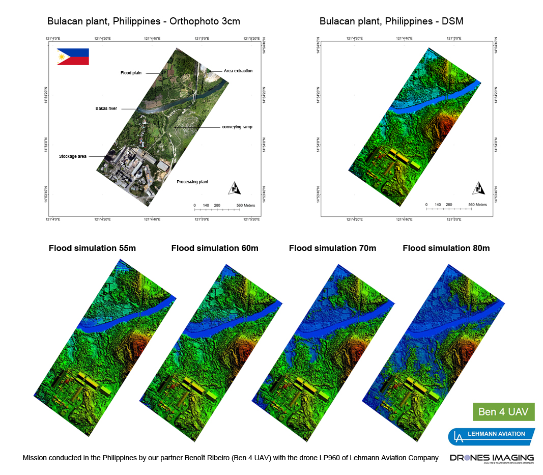
The Holcim cement plant is located in Bulacan region in the Philippines. The main site is located near rice fields and 400m from the Bakas River which separates it from the extraction site. During the storm floods, Bakas river floods the small valley between the extraction site and the main site.

In this context and in connection with Holcim company, Benoît Ribeiro, expert in conducting drone missions around the world for Lehmann aviation has used our post-processing services to establish a risk prevention plan to identify the flood impact on the industrial site. The 400 aerial images collected by Benoît Ribeiro were provided us from the Philippines (by internet connection) and we were able to quickly perform a series of simulations at different critical flood levels.

TECHNICAL INFORMATIONS

  • Data processing : Drones Imaging company.
  • Flights and aerial imagery : Benoît Ribeiro.
  • Spatial accuracy : decimeter.
  • Orthophoto RVB : GSD 3cm.
  • Drone fixed wing : LP960 Lehmann aviation.
  • Photogrammetry software : Metashape.
  • Exports formats : GeoTiff and Pdf.
  • Completion deadlines : 2 days.
  • Use case taught during our photogrammetry training : see more.
PrevPrécédentTerrestrial photogrammetry
SuivantEarthquake in Nepal – 3D modeling of Basantapur squareNext
  • Mentions légales
  • Français
  • English