Skip to content
Services et traitements des images aériennes
Twitter Facebook Linkedin
  • Français
  • English
DRONES IMAGING
  • Drones imaging
    • Who are we
  • images processing service
    • topographic service
    • thermographic service
    • agricultural service
    • automatic counting service
    • Use case
    • Product sheets
    • useful documentation
    • download guide
  • Trainings
    • training in photogrammetry metashape option
    • training in photogrammetry Pix4D option
    • Multispectral training
    • online photogrammetry training
  • Softwares
    • Agisoft Metashape photogrammetry software
    • Undet software
  • RTK Receivers
    • EMLID GNSS RTK Reach RS3
    • EMLID GNSS RTK Reach RS2+
    • Emlid GNSS RTK Reach RX
    • EMLID GNSS RTK Reach RS+
  • Sensors
    • Agrowing Multispectral cameras
  • News
  • Contact us
  • Toggle website search
Menu Close
  • Drones imaging
    • Who are we
  • images processing service
    • topographic service
    • thermographic service
    • agricultural service
    • automatic counting service
    • Use case
    • Product sheets
    • useful documentation
    • download guide
  • Trainings
    • training in photogrammetry metashape option
    • training in photogrammetry Pix4D option
    • Multispectral training
    • online photogrammetry training
  • Softwares
    • Agisoft Metashape photogrammetry software
    • Undet software
  • RTK Receivers
    • EMLID GNSS RTK Reach RS3
    • EMLID GNSS RTK Reach RS2+
    • Emlid GNSS RTK Reach RX
    • EMLID GNSS RTK Reach RS+
  • Sensors
    • Agrowing Multispectral cameras
  • News
  • Contact us
  • Toggle website search

Blog

  1. Home>
  2. geomatics>
  3. Flood forecasting: Topographic survey in Niamey to deal with the rise of the Niger River

Flood forecasting: Topographic survey in Niamey to deal with the rise of the Niger River

  • January 19, 2018
  • 8:53 am

Flood forecasting: Topographic survey in Niamey to deal with the rise of the Niger River

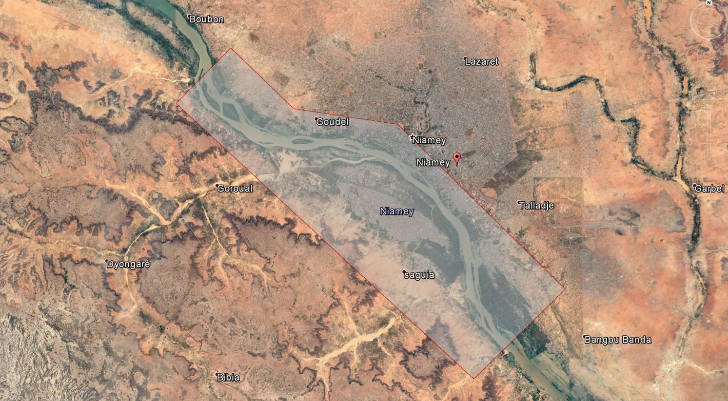
Flood forecasting by aerial photogrammetry: 3D modeling carried out over a length of 25Km (12300ha) for the prevention of risks related to flooding of the Niger River. Results obtained from 7000 aerial images taken by Drone Africa Service. Post-processing and deliverables by Drones Imaging.

3D animated

12300ha of covered area to the South-West of Niamey

flood-forecasting

3D dense cloud built for topographic study of the Niger River and its impact into the capital of Niamey in the event of a flood.

Dense cloud built with Metashape software and filtered into two classes: ground class and overground class (MNT and MNE) allowing a precise analysis of the terrain (cleared of buildings and vegetation) which constitute polluting elements for flood simulation with GIS. Now feasible, digital flood simulations will make it possible to prioritize development work (such as earthworks or the construction of dykes) in areas at risk with a view to protecting the first flood-prone districts.

Area covered in cross-capture: 12,300 hectares to the south-west of Niamey.

TECHNICAL INFORMATIONS

  • Data processing service : Drones Imaging company.
  • Flights and aerial imagery : Drone Africa Service company.
  • Spatial accuracy : centimeter.
  • Plane : ULM.
  • Sensor :  Sony ILCE 5100.
  • Covered area : 12300ha.
  • Dense cloud : 1 billion points.
  • Photogrammetry software : Metashape.
  • Export formats : Las.
  • Delivery delay : 6 days upon receipt of images dataset.
PrevPrécédentFlatness analysis of a swimming pool achieved by drone and aerial photogrammetry
SuivantRoof inspection by drone and photogrammetryNext
  • Mentions légales
  • Français
  • English