Skip to content
Services et traitements des images aériennes
Twitter Facebook Linkedin
  • Français
  • English
DRONES IMAGING
  • Drones imaging
    • Who are we
  • images processing service
    • topographic service
    • thermographic service
    • agricultural service
    • automatic counting service
    • Use case
    • Product sheets
    • useful documentation
    • download guide
  • Trainings
    • training in photogrammetry metashape option
    • training in photogrammetry Pix4D option
    • Multispectral training
    • online photogrammetry training
  • Softwares
    • Agisoft Metashape photogrammetry software
    • Undet software
  • RTK Receivers
    • EMLID GNSS RTK Reach RS3
    • EMLID GNSS RTK Reach RS2+
    • Emlid GNSS RTK Reach RX
    • EMLID GNSS RTK Reach RS+
  • Sensors
    • Agrowing Multispectral cameras
  • News
  • Contact us
  • Toggle website search
Menu Close
  • Drones imaging
    • Who are we
  • images processing service
    • topographic service
    • thermographic service
    • agricultural service
    • automatic counting service
    • Use case
    • Product sheets
    • useful documentation
    • download guide
  • Trainings
    • training in photogrammetry metashape option
    • training in photogrammetry Pix4D option
    • Multispectral training
    • online photogrammetry training
  • Softwares
    • Agisoft Metashape photogrammetry software
    • Undet software
  • RTK Receivers
    • EMLID GNSS RTK Reach RS3
    • EMLID GNSS RTK Reach RS2+
    • Emlid GNSS RTK Reach RX
    • EMLID GNSS RTK Reach RS+
  • Sensors
    • Agrowing Multispectral cameras
  • News
  • Contact us
  • Toggle website search

Blog

  1. Home>
  2. geomatics>
  3. Flatness analysis of a swimming pool achieved by drone and aerial photogrammetry

Flatness analysis of a swimming pool achieved by drone and aerial photogrammetry

  • December 29, 2017
  • 4:52 pm

Flatness analysis of a swimming pool by drone

Flatness analysis: 3d modeling by photogrammetry for the inspection of a swimming pool under construction. Results obtained from 310 aerial images, post-processing by Drones Imaging.

Map of detecting flatness defects

Flatness analysis

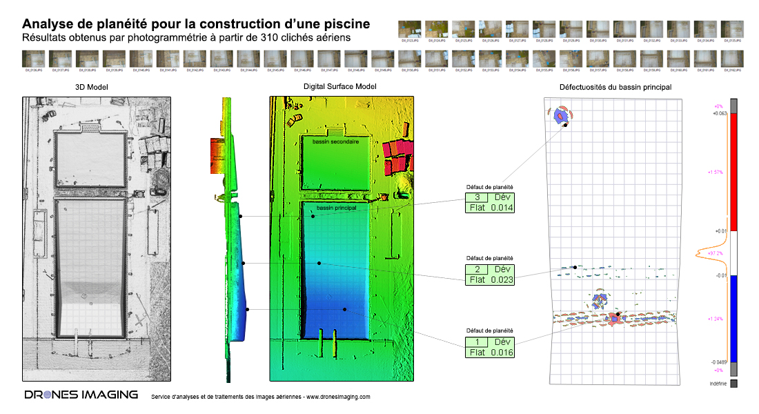
3D modeling carried out as part of a study to control the flatness of a swimming pool under construction (with a minimum tolerance of 1cm).

Through this commercial use cas, the analysis of the 3D model made it possible to extract about ten minor deformations (holes and bumps) whose tolerance is between 1 and 2cm but also to identify two superficial 3cm depressions. In conclusion, our results showed that 97.2% of the inspected surface was perfectly flat.

TECHNICAL INFORMATIONS

  • Data processing service : Drones Imaging company.
  • Inspected area : 1400m².
  • Drone : DJI Mavic pro.
  • Photogrammetry software : Metashape.
  • Dense cloud : 50 million points.
  • Export formats : GeoTiff et Obj.
  • Delivery delay : one day upon receipt imagery dataset.
PrevPrécédent3D modeling of a tourist residence by coupling laser and photogrammetric data
SuivantFlood forecasting: Topographic survey in Niamey to deal with the rise of the Niger RiverNext
  • Mentions légales
  • Français
  • English