Skip to content
Services et traitements des images aériennes
Twitter Facebook Linkedin
  • Français
  • English
DRONES IMAGING
  • Drones imaging
    • Who are we
  • images processing service
    • topographic service
    • thermographic service
    • agricultural service
    • automatic counting service
    • Use case
    • Product sheets
    • useful documentation
    • download guide
  • Trainings
    • training in photogrammetry metashape option
    • training in photogrammetry Pix4D option
    • Multispectral training
    • online photogrammetry training
  • Softwares
    • Agisoft Metashape photogrammetry software
    • Undet software
  • RTK Receivers
    • EMLID GNSS RTK Reach RS3
    • EMLID GNSS RTK Reach RS2+
    • Emlid GNSS RTK Reach RX
    • EMLID GNSS RTK Reach RS+
  • Sensors
    • Agrowing Multispectral cameras
  • News
  • Contact us
  • Toggle website search
Menu Close
  • Drones imaging
    • Who are we
  • images processing service
    • topographic service
    • thermographic service
    • agricultural service
    • automatic counting service
    • Use case
    • Product sheets
    • useful documentation
    • download guide
  • Trainings
    • training in photogrammetry metashape option
    • training in photogrammetry Pix4D option
    • Multispectral training
    • online photogrammetry training
  • Softwares
    • Agisoft Metashape photogrammetry software
    • Undet software
  • RTK Receivers
    • EMLID GNSS RTK Reach RS3
    • EMLID GNSS RTK Reach RS2+
    • Emlid GNSS RTK Reach RX
    • EMLID GNSS RTK Reach RS+
  • Sensors
    • Agrowing Multispectral cameras
  • News
  • Contact us
  • Toggle website search

Blog

  1. Home>
  2. geomatics>
  3. Inspection of structures by drone – circularity study of a water tower

Inspection of structures by drone – circularity study of a water tower

  • August 10, 2018
  • 2:36 pm

Engineering structure inspection: circularity study of a water tower by photogrammetry.

Engineering structure inspection: results obtained from 211 aerial images taken by the company Adeole, post processing by Drones Imaging.

Inspection performed as part of a study to detect surface deformations and vertical defects of a circular structure.

A relevant and directly applicable use case for the inspection of storage tanks (oil & gas), treatment plants, agricultural tanks, towers or dungeons for example.

Surface auscultation
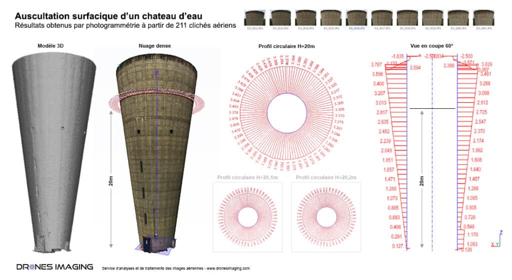
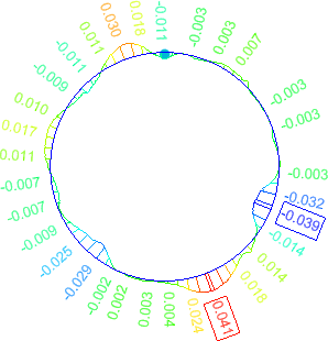
Engineering structure inspection

Circularity study

Calculation of successive horizontal sections over the entire height of the water tower (from the dense cloud and every 10 cm) made possible the detection of a dozen surface defects (mainly concrete bursts). The 240 profiles thus generated, also made it possible to control the verticality of the structure with respect to a vertical reference axis.

Engineering structure inspection

TECHNICAL INFORMATIONS

  • Data processing service : Drones Imaging company.
  • Flights and erial images source : Adeole company.
  • Spatial accuracy : centimeter.
  • Orthophoto RVB : GSD 1mm.
  • Total area inspected : 950m².
  • Drone : Matrice 200.
  • Photogrammetry software : Metashape.
  • Export formats : GeoTiff and Dwg autocad.
  • Delivery delay : 2 days.
PrevPrécédentAuscultation of a water tower walls by drone and automatic damages detection
SuivantCliff inspection by drone and photogrammetryNext
  • Mentions légales
  • Français
  • English